App ist vorübergehend nicht verfügbar

World History Maps: N America
Veröffentlicht von:
WORLD HISTORY MAPS
Downloads
Umsatz
Beschreibung
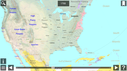
World History Maps: N America, by World History Maps Inc, is a new and unique way of looking at the history of North America. Instead of an historical atlas which has maps showing North America (or a region) at a few significant years, or maps that try to compress decades of change on to one map, we offer a different approach. Our interactive historical maps show the entire continent for every single year since 1492. This is an unprecedented amount of detail in time for North America that cannot be found anywhere else. The scalable maps allow even the smallest places to be shown. Looking at History in this detail gives one a unique perspective. These historical maps are made using GIS technology. These maps are just like our World app maps but with more details. In addition to countries, major Tribes, and Peoples at the beginning of each year, we also also show states and provinces, towns and cities, battles, parks, reservations and reservoirs, and many events including weather events. Maps are Scaleable and zoomable with popup information. Scrolling forward and backward is available with adjustable speeds. Maps can be pinned so you can toggle back and forth to compare different years. Following below are more details about how to use the app.
Ausblenden
Mehr anzeigen...
Screenshots
World History Maps Häufige Fragen
-
Ist World History Maps kostenlos?
Ja, World History Maps ist komplett kostenlos und enthält keine In-App-Käufe oder Abonnements.
-
Ist World History Maps seriös?
Nicht genügend Bewertungen, um eine zuverlässige Einschätzung vorzunehmen. Die App benötigt mehr Nutzerfeedback.
Danke für die Stimme -
Wie viel kostet World History Maps?
World History Maps ist kostenlos.
-
Wie hoch ist der Umsatz von World History Maps?
Um geschätzte Einnahmen der World History Maps-App und weitere AppStore-Einblicke zu erhalten, können Sie sich bei der AppTail Mobile Analytics Platform anmelden.

Benutzerbewertung
Die App ist in Kasachstan noch nicht bewertet.

Bewertungsverlauf
World History Maps Bewertungen
Keine Bewertungen in Kasachstan
Die App hat noch keine Bewertungen in Kasachstan.
World History Maps Installationen
Letzte 30 TageWorld History Maps Umsatz
Letzte 30 TageWorld History Maps Einnahmen und Downloads
Gewinnen Sie wertvolle Einblicke in die Leistung von World History Maps mit unserer Analytik.
Melden Sie sich jetzt an, um Zugriff auf Downloads, Einnahmen und mehr zu erhalten.
Melden Sie sich jetzt an, um Zugriff auf Downloads, Einnahmen und mehr zu erhalten.
App-Informationen
- Kategorie
- Education
- Herausgeber
- WORLD HISTORY MAPS
- Sprachen
- English
- Letzte Veröffentlichung
- 1.4 (vor 4 Jahren )
- Veröffentlicht am
- Jul 23, 2018 (vor 6 Jahren )
- Auch verfügbar in
- Vereinigte Staaten , Saudi-Arabien , Vereinigte Arabische Emirate , Japan , Südkorea , Kasachstan , Libanon , Mexiko , Malaysia , Nigeria , Niederlande , Norwegen , Neuseeland , Peru , Polen , Rumänien , Russland , Schweden , Türkei , Taiwan , Ukraine , Irland , Österreich , Aserbaidschan , Belgien , Brasilien , Kanada , Kolumbien , Deutschland , Dänemark , Dominikanische Republik , Algerien , Ecuador , Spanien , Frankreich , Vereinigtes Königreich , Griechenland , Italien , Pakistan , Portugal , China , Chile , Indonesien , Argentinien
- Zuletzt aktualisiert
- vor 1 Jahr
This page includes copyrighted content from third parties, shared solely for commentary and research in accordance with fair use under applicable copyright laws. All trademarks, including product, service, and company names or logos, remain the property of their respective owners. Their use here falls under nominative fair use as outlined by trademark laws and does not suggest any affiliation with or endorsement by the trademark holders.
- © 2024 AppTail.
- Unterstützung
- Privacy
- Terms
- All Apps

