Приложение временно недоступно

CartoMobile
Geographical field data tool
Описание
** Visit the App homepage to view our video tutorials and documentation (available in PDF and ePub format) **
CartoMobile® transforms your iOS device into a mobile geospatial data entry device. View, add, or edit data in the field. Add pictures to points to clarify your observations.
In network mode, use it to connect to your WFS and WMS servers to view and maintain data in real time.
In ad hoc mode, CartoMobile can operate without an internet connection to browse local data sets and enter information for download from the device later.
Features include:
- Works natively with industry-standard SHP files with almost any native projection (reprojecting on the fly)
- Supports MrSID, GeoTIFF, JPEG, JPEG2000, and ECW raster formats for background imagery
- Supports automatically remapping Coordinate Reference Systems (Projections)
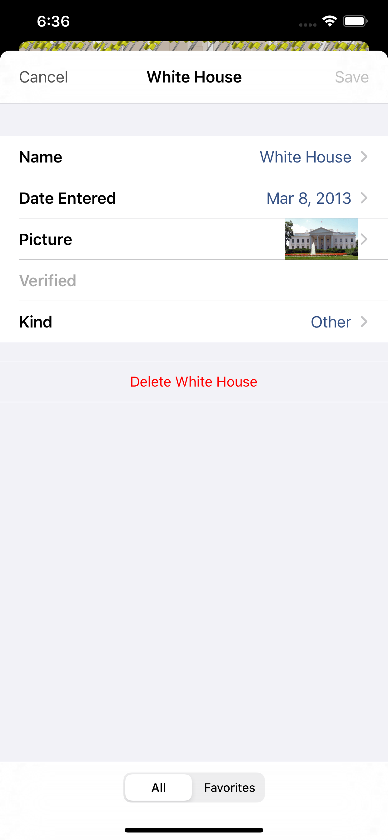
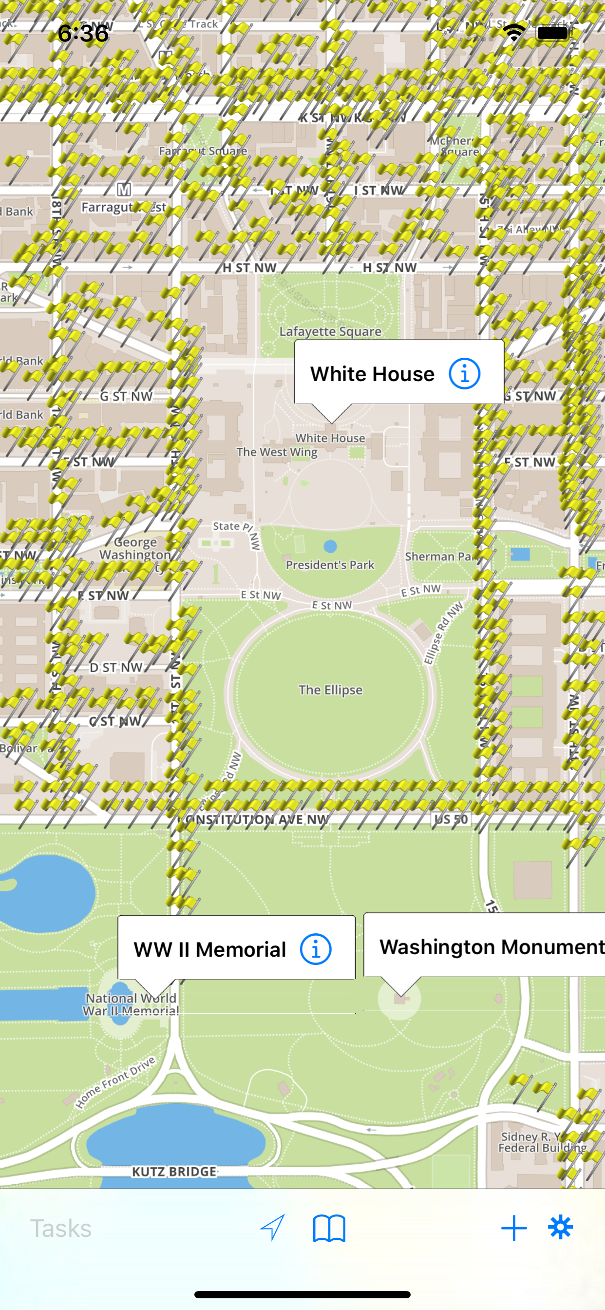
- View, modify, and add new points, lines, and polygons with attribute data
- View multiple layers to create and overview, or toggle layers on and off for clarity
- On-device caching of background data for offline use
- Create dedicated maps for each project and switch between them with ease
- Exchange configurations and data via email
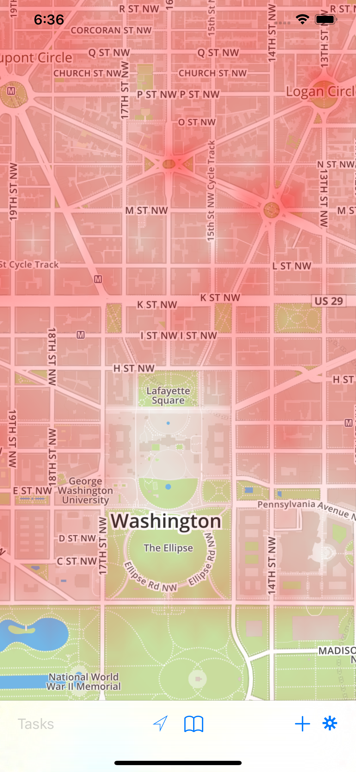
- Heat maps to represent high density areas
- Flexible data entry forms, with 12 form types including choice fields and check boxes
- Add photos to your GIS data directly from the camera or your Pictures (retrieving data from the camera requires and iOS supported camera)
- Integration with iOS Maps application for directions
- Task system available in multi-user environments to assign tasks to individual users
Please contact us through support for advanced configuration options for use with WFS Servers, decision-tree data entry, and task-based data entry and update.
Additional configuration options and customization now available for your specific needs, contact us through support or via our web site for more information.
Скрыть
Показать больше...
CartoMobile® transforms your iOS device into a mobile geospatial data entry device. View, add, or edit data in the field. Add pictures to points to clarify your observations.
In network mode, use it to connect to your WFS and WMS servers to view and maintain data in real time.
In ad hoc mode, CartoMobile can operate without an internet connection to browse local data sets and enter information for download from the device later.
Features include:
- Works natively with industry-standard SHP files with almost any native projection (reprojecting on the fly)
- Supports MrSID, GeoTIFF, JPEG, JPEG2000, and ECW raster formats for background imagery
- Supports automatically remapping Coordinate Reference Systems (Projections)
- View, modify, and add new points, lines, and polygons with attribute data
- View multiple layers to create and overview, or toggle layers on and off for clarity
- On-device caching of background data for offline use
- Create dedicated maps for each project and switch between them with ease
- Exchange configurations and data via email
- Heat maps to represent high density areas
- Flexible data entry forms, with 12 form types including choice fields and check boxes
- Add photos to your GIS data directly from the camera or your Pictures (retrieving data from the camera requires and iOS supported camera)
- Integration with iOS Maps application for directions
- Task system available in multi-user environments to assign tasks to individual users
Please contact us through support for advanced configuration options for use with WFS Servers, decision-tree data entry, and task-based data entry and update.
Additional configuration options and customization now available for your specific needs, contact us through support or via our web site for more information.
Скриншоты

CartoMobile Частые Вопросы
-
Приложение CartoMobile бесплатное?
Да, CartoMobile полностью бесплатное и не содержит встроенных покупок или подписок.
-
Является ли CartoMobile фейковым или мошенническим?
Недостаточно отзывов для надежной оценки. Приложению нужно больше отзывов пользователей.
Спасибо за ваш голос -
Сколько стоит CartoMobile?
Приложение CartoMobile бесплатное.
-
Сколько зарабатывает CartoMobile?
Чтобы получить оценку дохода приложения CartoMobile и другие данные AppStore, вы можете зарегистрироваться на платформе мобильной аналитики AppTail.

Оценки пользователей
Приложение еще не оценено в Южно-Африканская Республика.
История оценок
CartoMobile Отзывы Пользователей
У приложения еще нет отзывов
CartoMobile Установки
30дн.
CartoMobile Доход
30дн.CartoMobile Доходы и Загрузки
Получите ценные инсайты о производительности CartoMobile с помощью нашей аналитики.
Зарегистрируйтесь сейчас, чтобы получить доступ к статистика загрузок и доходов и многому другому.
Зарегистрируйтесь сейчас, чтобы получить доступ к статистика загрузок и доходов и многому другому.
Информация о приложении
- Категория
- Productivity
- Языки
- English, French, German, Spanish
- Последнее обновление
- 2.1.2 (4 года назад )
- Выпущено
- Dec 29, 2010 (13 лет назад )
- Также доступно в
- Соединенные Штаты, Швейцария, Китай, Индонезия, Италия, Польша, Южно-Африканская Республика
- Обновлено
- 1 год назад
AppTail.