EasyTrails GPS Lite

Разработчик: Zirak s.r.l
Скачивания
Доход

Описание

EasyTrails GPS LITE is the LITE version of EasyTrails GPS, the complete GPS tracker app for your iPhone.
The perfect application for those who are passionate about OUTDOOR ACTIVITIES and TRAVELING, everybody who likes outdoor sports, and not only.
Are you going for a bike or motorcycle ride? Well, EasyTrails GPS will tell you how many miles you traveled, how much time you spent, how high you climbed and many other details. In real-time it will show you the course on a map, comparing it with downloaded tracks and points of interest.
You can import or share all tracks and waypoints, photos and ideas for new journeys with your friends.
Share where you are on Facebook and Twitter through your GPS position, and export your tracks in standard formats, so you can review them on Google Earth, SportTracks and TrailsRunner. Or simply upload them to online services like Garmin Connect, or many others.
It's possible to import tracks by e-mail or Safari (EasyTrails can handle GPX, KML/KMZ and ZIP file formats), or by wi-fi networks, using an improved and easy to use web-based sharing feature.
With the FULL version, you can also calculate routes and let EasyTrails guide you using the new navigation capabilities. You can also let it guide you through previously recorded tracks.
Additionally, EasyTrails GPS can communicate with navigators like Maps, Google Maps, TomTom or Waze (if installed) for more advanced guidance needs.
Load custom cartography, EasyTrails supports KMZ and MBTILES formats.
► For more info, visit our website: www.easytrailsgps.com

NEW FEATURES:
► Heart rate monitoring (paid)
We added the ability to connect to compatible Bluetooth heart rate monitors (such as Polar H6 and H7 devices). Heart rate can be seen in real time from the dashboard.
With the 'Heart rate monitoring' in-app purchase:
- heart rate data will be associated to GPS tracks
- saved tracks will have an extra heart rate chart
- heart rate data will be saved to HealthKit
Additionally, with the 'Colored tracks' in-app purchase, it will be possible to highlight heart rate data directly on the map screen of a recorded track.
OTHER FEATURES:
- Support for many different map types
- Support for different coordinate systems
- Support for user-loaded offline cartography (KMZ and MBTILES)
- Export tracks (single or multiple) in standard formats (GPX, KML/KMZ and CSV), with their associated waypoints and pictures
- Import tracks (GPX and KML/KMZ)
- Import waypoints (GPX and KML/KMZ)
- Resume recording of tracks
- Save waypoints with photos and descriptions
- Navigate to a point of interest
- Sharing via Facebook and Twitter
- Follow a path/track
- Navigate (distance / direction) towards any waypoint
- Navigate (distance / direction) towards any track marker (start / pause / resume / end points)
- Advanced Navigation to a waypoint using any navigation app you may have installed
- Upload tracks to GPSies (http://www.gpsies.com)
- Upload tracks to SportTracks (http://sporttracks.mobi)
- Upload tracks to OpenTrail (http://www.opentrail.us)
- Upload tracks to OkMap (http://www.okmap.org)
- Real-time visualization of distance, speed, altitude bearing and other data
- Map Visualization in different modes: street map, satellite, hybrid, terrain
- Charts (elevation profiles, ...)
- Digital Compass
- Heart rate monitoring
- Turn by turn directions
- High battery duration (record in standby)
- Select between metric, imperial and nautical measuring systems
- Intuitive and User Friendly interface
- Lightweight, reliable and accurate
- Doesn't require internet connection
Terms of Use: https://www.apple.com/legal/internet-services/itunes/dev/stdeula/
Privacy Policy: http://www.easytrailsgps.com/wp-content/uploads/2016/05/EasyTrails-GPS-Privacy-Policy.pdf
Скрыть Показать больше...

Встроенные покупки

Remove ads
¥8.00
Cloud storage
¥26.00
Download maps
¥15.00
iWatch Remote
¥15.00
Colored tracks
¥8.00
Add search tracks
¥8.00
Coordinate systems
¥8.00
Heart rate monitoring
¥15.00
Remove track recording duration limit
¥15.00
Remove track and waypoint number limit
¥15.00

Скриншоты

EasyTrails GPS Lite Частые Вопросы

  • Приложение EasyTrails GPS Lite бесплатное?

    Да, EasyTrails GPS Lite можно скачать бесплатно, однако в приложении есть встроенные покупки или подписки.

  • Является ли EasyTrails GPS Lite фейковым или мошенническим?

    ⚠️ Приложение EasyTrails GPS Lite имеет низкие оценки и отрицательные отзывы. Пользователи, похоже, недовольны его качеством или функциями.

    Спасибо за ваш голос

  • Сколько стоит EasyTrails GPS Lite?

    EasyTrails GPS Lite имеет несколько покупок/подписок внутри приложения, средняя цена покупки составляет ¥13.30.

  • Сколько зарабатывает EasyTrails GPS Lite?

    Чтобы получить оценку дохода приложения EasyTrails GPS Lite и другие данные AppStore, вы можете зарегистрироваться на платформе мобильной аналитики AppTail.

Оценки пользователей

4 из 5

1 оценок в Китай

5 star
0
4 star
1
3 star
0
2 star
0
1 star
0
История оценок

EasyTrails GPS Lite Отзывы Пользователей

Good but

LovelyUser1979 on

Россия

Lite ver has a very short limit on rec of tracks. Really, like 1 km or smth... I know it's free If you test before purchase - download. If u want just use free one - u won't get much of free ver.

Useful tool

yanlb on

Китай

But I would never let it use my location in the background. So please do not ask me to allow this again and again, again and again. OK?

要是卫星地图进行纠偏就太好了

敬礼娃娃 on

Китай

非常喜欢的一款软件,唯一的遗憾是卫星地图定自己位置时与实际有偏差无纠偏处理,希望改正。

不支持外来轨迹导入

东海泛舟 on

Китай

其他都很好,只是外来轨迹如garmin文件的导入会产生错误显示

OPEN TOPO MAP

Vivi&Max on

Италия

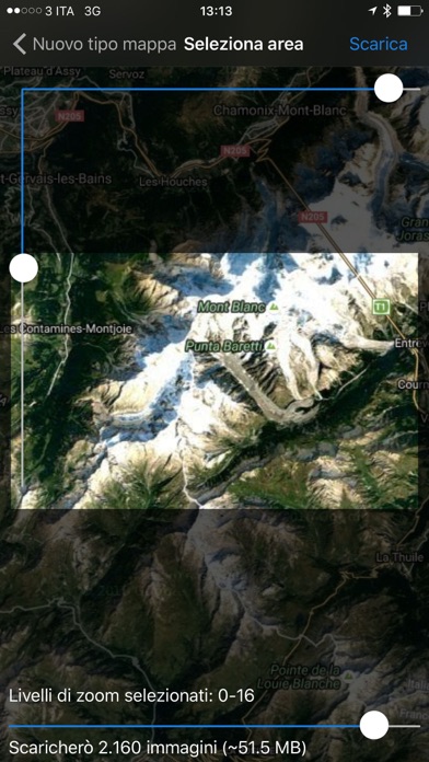
Sono costretta a reinviarvi questo messaggio qualche anno dopo: Fino a poco tempo fa potevo appoggiarmi a OPEN TOPO MAP andando per boschi, ora non riesco più a caricarla, ho anche scaricato la versione a pagamento, ma la situazione è uguale. Grazie!

OPEN TOPO MAP

Vivi&Max on

Италия

Fino a poco tempo fa potevo appoggiarmi a OPEN TOPO MAP andando per boschi, ora non riesco più a caricarla, ho anche scaricato la versione a pagamento, ma la situazione è uguale. Grazie!

Molto bello e facile da usare

pas3008 on

Италия

Ottima applicazione

Valutazione App

palanchina on

Италия

La sto usando da poco per adesso ottimo servizio

Inutile

UgodiLucca on

Италия

Nn ti fa scaricare nemmeno una traccia, ma come si fa a valutarla ?? Cancellata

Fantastica

Miroklose1970 on

Италия

Al momento la sto ancora testando ma devo dire che è molto funzionale

Оценки

История позиций в топах
История рейтингов пока не доступна
Позиции в категории
Рейтинг
Категория
Позиция
Топ по доходу
90
Топ бесплатных
296
Топ бесплатных
351
Топ бесплатных
359
Топ бесплатных
407

EasyTrails GPS Lite Конкуренты

Name
georesq
Outdoor Trentino
Terra Map - Trail Explorer
Outdoor trails & topo charts
Open GPX Tracker
No ads, no in-app purchases
Via Francigena – Official App
A trip in the Europe heart
WHIP LIVE Moto, Bike, Trekking
Track • Navigate • Explore
MowiBike
MTB, Bike Parks & Trail Areas
Mappa Digitale Sentiero Italia
La mappa digitale ufficiale
OkMap Mobile
An off road GPS navigator
Altimeter Mountain GPS Tracker
Altimeter & Tracker For Hikers

EasyTrails GPS Lite Установки

Last 30 days

EasyTrails GPS Lite Доход

Last 30 days

EasyTrails GPS Lite Доходы и Загрузки

Получите ценные инсайты о производительности EasyTrails GPS Lite с помощью нашей аналитики.
Зарегистрируйтесь сейчас, чтобы получить доступ к статистика загрузок и доходов и многому другому.

Информация о приложении

Категория
Navigation
Разработчик
Zirak s.r.l
Языки
Dutch, English, French, German, Italian, Portuguese, Russian, Chinese, Spanish, Chinese
Последнее обновление
11.8 (3 месяца назад )
Выпущено
Aug 14, 2009 (15 лет назад )
Обновлено
6 дней назад