
Elevation For Real
Разработчик: homedatasheet.com
Описание
Get real-time elevation from your iOS device's GPS receiver and built-in geoid model.
As a bonus, we've also included access to the USGS Elevation Web Service which provides US ground elevation data. You'll be amazed at how, when you have a good view of the sky, Elevation For Real's internally generated elevation converges on the USGS value after just a short time. Outside the U.S., or on iOS devices with non-U.S. region settings, or if the USGS elevation service is unavailable, Shuttle Radar Topography Mission (SRTM) published elevation data is shown between 60°N and 56°S latitude.
Here are some more features:
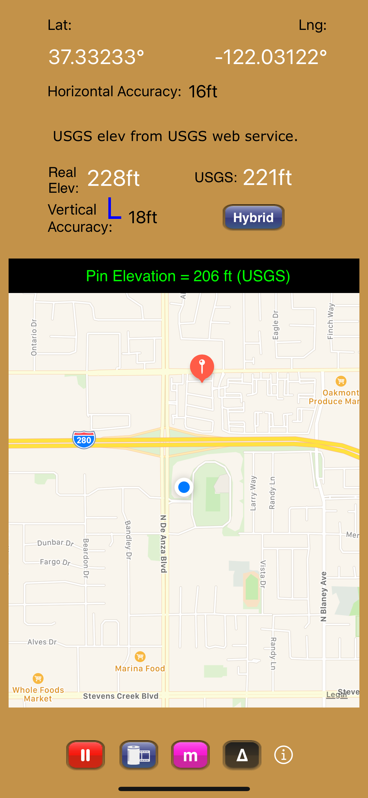
- Real-time map which displays your location
- Estimated vertical and horizontal accuracy
- Spot elevation data displayed by tapping map
- English or metric units based on your region setting
- Start/Stop button
- One touch screenshots
- NO Third-Party Ads!
- Optional pressure altimeter (in-app purchase). Measure relative altitudes or calibrate to an elevation benchmark. Use indoors or out. Even works in Airplane Mode! Note: your iOS device must be equipped with a barometer to access pressure altimeter functionality. The iPhone 6 and later and the iPad Air 2 and later have barometers.
Download Elevation For Real today!
Notes:
1) homedatasheet.com, Inc. is not affiliated with USGS. USGS Elevation Web Service is available to the general public online, at no cost.
2) SRTM is provided by geonames.org. homedatasheet.com, Inc. is not affiliated with geonames.org. U.S.-based users should note that, in many instances, the SRTM data is not as accurate as USGS data. All users should note that, in certain locations, the SRTM dataset may be tens of meters or more in error.
3) ***The initial view of this app requires a GPS signal to work properly. A clear view of the sky is needed for GPS reception, and it may take several seconds to get a position fix. Elevation for Real will run on devices not equipped with a GPS receiver and GPS-equipped devices that are not receiving a GPS signal, but any resulting elevation readings will just be the approximate ground elevation at your location, even if you are several stories up in a tall building.
4) ***Any elevation measurements with personal safety or financial implications should be performed by professionals with professional GPS equipment. Elevation for Real is not intended to determine flood hazard. Consult a licensed professional in your jurisdiction, such as a surveyor or engineer, when dealing with flood risk.
Скрыть
Показать больше...
As a bonus, we've also included access to the USGS Elevation Web Service which provides US ground elevation data. You'll be amazed at how, when you have a good view of the sky, Elevation For Real's internally generated elevation converges on the USGS value after just a short time. Outside the U.S., or on iOS devices with non-U.S. region settings, or if the USGS elevation service is unavailable, Shuttle Radar Topography Mission (SRTM) published elevation data is shown between 60°N and 56°S latitude.
Here are some more features:
- Real-time map which displays your location
- Estimated vertical and horizontal accuracy
- Spot elevation data displayed by tapping map
- English or metric units based on your region setting
- Start/Stop button
- One touch screenshots
- NO Third-Party Ads!
- Optional pressure altimeter (in-app purchase). Measure relative altitudes or calibrate to an elevation benchmark. Use indoors or out. Even works in Airplane Mode! Note: your iOS device must be equipped with a barometer to access pressure altimeter functionality. The iPhone 6 and later and the iPad Air 2 and later have barometers.
Download Elevation For Real today!
Notes:
1) homedatasheet.com, Inc. is not affiliated with USGS. USGS Elevation Web Service is available to the general public online, at no cost.
2) SRTM is provided by geonames.org. homedatasheet.com, Inc. is not affiliated with geonames.org. U.S.-based users should note that, in many instances, the SRTM data is not as accurate as USGS data. All users should note that, in certain locations, the SRTM dataset may be tens of meters or more in error.
3) ***The initial view of this app requires a GPS signal to work properly. A clear view of the sky is needed for GPS reception, and it may take several seconds to get a position fix. Elevation for Real will run on devices not equipped with a GPS receiver and GPS-equipped devices that are not receiving a GPS signal, but any resulting elevation readings will just be the approximate ground elevation at your location, even if you are several stories up in a tall building.
4) ***Any elevation measurements with personal safety or financial implications should be performed by professionals with professional GPS equipment. Elevation for Real is not intended to determine flood hazard. Consult a licensed professional in your jurisdiction, such as a surveyor or engineer, when dealing with flood risk.
Встроенные покупки
- Pressure Altimeter
- Rp 19ribu
Скриншоты

Elevation For Real Частые Вопросы
-
Приложение Elevation For Real бесплатное?
Да, Elevation For Real можно скачать бесплатно, однако в приложении есть встроенные покупки или подписки.
-
Является ли Elevation For Real фейковым или мошенническим?
Недостаточно отзывов для надежной оценки. Приложению нужно больше отзывов пользователей.
Спасибо за ваш голос -
Сколько стоит Elevation For Real?
Elevation For Real имеет несколько покупок/подписок внутри приложения, средняя цена покупки составляет 19.00 Rp.
-
Сколько зарабатывает Elevation For Real?
Чтобы получить оценку дохода приложения Elevation For Real и другие данные AppStore, вы можете зарегистрироваться на платформе мобильной аналитики AppTail.

Оценки пользователей
Приложение еще не оценено в Индонезия.
История оценок
Elevation For Real Отзывы Пользователей
Нет отзывов в Индонезия
Приложение пока не имеет отзывов в Индонезия.
Оценки
История позиций в топах
История рейтингов пока не доступна
Позиции в категории
Приложение еще не было в топах
Ключевые слова
Elevation For Real Конкуренты
| Name | Скачивания (30d) | Ежемесячный доход | Отзывы | Оценки | Последнее обновление | |
|---|---|---|---|---|---|---|

Terrain Radar Altimeter
Altimeter with elevation chart
|
Открыть
|
Открыть
|
0
|
1
|
10 месяцев назад | |

My Altitude and Elevation GPS
Elevation over surface.
|
Открыть
|
Открыть
|
0
|
|
1 месяц назад | |
|
Elevation - Altimeter Map
Find your altitude on the map
|
Открыть
|
Открыть
|
0
|
1
|
1 месяц назад | |

Topo Nomad
USGS Topographical Maps
|
Открыть
|
Открыть
|
1
|
|
2 года назад | |

Topo Reader
USGS Topographical Maps
|
Открыть
|
Открыть
|
1
|
|
2 года назад | |

Pro Altimeter - Barometric+GPS
Manual/GPS/METAR Calibration
|
Открыть
|
Открыть
|
0
|
|
7 месяцев назад | |

Altitude measurement
elevation, height above sea
|
Открыть
|
Открыть
|
0
|
|
3 года назад | |

Altimeter - altitude and more
Altitude, location, navigation
|
Открыть
|
Открыть
|
0
|
|
4 месяца назад | |

Map Altimeter
Altitude Here and There
|
Открыть
|
Открыть
|
0
|
|
1 год назад | |

Altimeter Tracker
New! Pro grade alti tracking.
|
Открыть
|
Открыть
|
0
|
|
1 год назад |
Elevation For Real Установки
30дн.
Elevation For Real Доход
30дн.Elevation For Real Доходы и Загрузки
Получите ценные инсайты о производительности Elevation For Real с помощью нашей аналитики.
Зарегистрируйтесь сейчас, чтобы получить доступ к статистика загрузок и доходов и многому другому.
Зарегистрируйтесь сейчас, чтобы получить доступ к статистика загрузок и доходов и многому другому.
Информация о приложении
- Категория
- Navigation
- Разработчик
- homedatasheet.com
- Языки
- English
- Последнее обновление
- 11.0 (2 месяца назад )
- Выпущено
- Dec 29, 2009 (14 лет назад )
- Также доступно в
- Великобритания, Соединенные Штаты, Австралия, Чили, Аргентина, Таиланд, Саудовская Аравия, Филиппины, Нидерланды, Япония, Италия, Израиль, Ирландия, Гонконг (САР), Франция, Испания, Германия, Австрия, Канада, Швейцария, Азербайджан, Бразилия, Новая Зеландия, Перу, Бельгия, Пакистан, Польша, Португалия, Румыния, Мексика, Швеция, Сингапур, Турция, Тайвань, Украина, ОАЭ, Вьетнам, Южно-Африканская Республика, Колумбия, Эквадор, Египет, Доминиканская Республика, Финляндия, Дания, Греция, Чехия, Венгрия, Индонезия, Нигерия, Китай, Индия, Республика Корея, Кувейт, Казахстан, Ливан, Алжир, Малайзия
- Обновлено
- 1 месяц назад
AppTail.