Flytomap All in One HD Charts

Charts & Maps GPS Navigator

Разработчик: Flytomap
Скачивания
Доход

Описание

FlyToMap™ is a valid and interesting alternative, Benetti Yachts
► The charts downloaded are resident in the app. No internet connection required!
Flytomap All In One HD works on all Apple devices
FlyToMap™ offers a revolutionary app; you can download any chart worldwide (500+) free of charge
Check out your area on viewer.flytomap.com
- All USA Marine charts (US All, East, West, Great Lakes, Major Rivers, Florida, Texas, California, etc.)
- USA Lake Maps 15000+ : Minnesota, Maine, Michigan, Massachusetts, Wisconsin, Texas, California, Florida, Iowa, North and South Dakota...and many more.
- 150+ USA Parks and Forests
- Australia Marine Charts
- Australia Parks
- New Zealand Marine charts
- All Europe Marine Charts
- 200+ major EU Parks
- The world's most famous holiday destinations ie: Caribbean, Seychelles, Mauritius, Maldives, Canary Islands, Azores, Bora Bora, Bali, Oslo Fjord .. and many more.
- Canada Lake Maps: Alberta, Lake of the Wood.. and many more.
► Worldwide Marine and Outdoor Maps available, thanks to viewer.flytomap.com
► Worldwide Satellite images overlay on charts
► Worldwide Terrain features overlay on charts, thanks to Open Street Map, Open Cycle Map, Bing, Earth, GMap
► Interactive Weather forecast
► NOAA raster charts seamless with continuous updates from the official Government server
► ActiveCaptain - Worldwide boaters community, with 200.000 + Captains
Use to Explore:
√ Latitudes and Longitudes to go to your favorite places
√ Search your Favorite points directly
√ Zoom, Rotate and Pan fast just by a finger touch
√ Quick Object information just tapping, thanks to vector technology
√ GPS Heading Vector Towards the direction movement
√ Distance Measurement Tool to easily calculate the distance from one location to another
√ Route planning, unlimited Waypoints - Insert the target/destination and see in real time your speed, distance and bearing
√ Magnified Lens for all info
√ Unlimited Tracks, Markers, Geo-tagged photos, records and share via email, visible on Google, Flytomap Viewer, KMZ format - Store your track without the need of cellular data or mobile signal
√ Select Depth Contours
√ a la carte menu
√ iOS background mode - Flytomap works in background as well, you can swap with another app and receive/make calls send sms while track recording.
√ Optimized battery usage
√ And so much more to come - It’s the only app you will ever need! Our charts are installed on: NAVICO LOWRANCE B&G NORTHSTAR EAGLE SIMRAD
Follow us:
▶ Twitter @flytomap
▶ Web Site flytomap.com
▶ Facebook facebook.com/flytomap

FlytoMap™ has a wide range of Applications and Maps for you to use - Free of charge on Flytomap All In One !
- WATER MAPS
Electronic Nautical Charts with the same accuracy and detail as on your chart plotter. Maps include Coastline, Anchoring areas, Fishing areas, Restriction areas, Obstructions, Rocks, Buoys, Beacons, Lights, Depth contours, Spot Soundings and more.
- LAKE MAPS
High quality lake maps with detailed information: Depth Contours, Boat Ramps, Fishing spots etc. Maps also include Trails, Roads and Railways information.
- PARK MAPS:
Extremely advanced electronic charts with information collected from National/State Park and Forest Services and many other local sources. The maps contain trails (Hiking, Biking, Equestrian trails etc.,) and Points of interest (POI) like Campgrounds, Visitor Centers, Lookout points, Eating places, Ranger Stations, Picnic areas, Boat/Canoe ramps, Parking areas etc..
- TRAVEL MAPS
These Maps cover the most interesting touristic areas combining Sea and Land information to allow you a complete travel experience.
Скрыть Показать больше...

Встроенные покупки

Marine: Ireland HD
$0.00
US Rivers HD GPS Charts
$0.00
Maldives GPS Map Navigator
$0.00
Australia Nautical Charts HD
$0.00
Cherbourg Channel Is. Solent
$0.00
Boating USA HD Nautical Charts
$0.00
Chesapeake Bay HD - GPS Charts
$0.00
German rivers GPS nautical map
$0.00
New Zealand Nautical Charts HD
$0.00
The Blue Hills Reservation GPS
$0.00

Скриншоты

Flytomap All in One HD Charts Частые Вопросы

  • Приложение Flytomap All in One HD Charts бесплатное?

    Нет, Flytomap All in One HD Charts не является бесплатным (стоит 29.99), и также содержит встроенные покупки.

  • Является ли Flytomap All in One HD Charts фейковым или мошенническим?

    🤔 Качество приложения Flytomap All in One HD Charts спорное. Некоторые пользователи довольны, в то время как другие сообщают о проблемах. Рекомендуем ознакомиться с отдельными отзывами для получения более полной картины.

    Спасибо за ваш голос

  • Сколько стоит Flytomap All in One HD Charts?

    Flytomap All in One HD Charts стоит 29.99 для загрузки (и также имеются дополнительные покупки внутри приложения).

  • Сколько зарабатывает Flytomap All in One HD Charts?

    Чтобы получить оценку дохода приложения Flytomap All in One HD Charts и другие данные AppStore, вы можете зарегистрироваться на платформе мобильной аналитики AppTail.

Оценки пользователей
Приложение еще не оценено в Новая Зеландия.
История оценок

Flytomap All in One HD Charts Отзывы Пользователей

Спасибо.

aumnavigator on

Россия

3 марта купил и обнаружил вылет программы при загрузки карт. Написал в суппорт. 6 марта исправили. Спасибо за оперативность. Но на картах offline отсутствуют буи.

Free nautical charts

Orlando_Furioso on

Соединенные Штаты

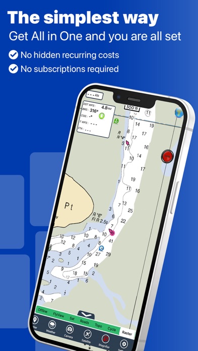
This is the real plus of the app, lot of details, all charts available no subscription no inapp, no advertisements.

Interesting app

Ron_2000 on

Соединенные Штаты

Great coverage, no subscription, multiple features. I found it reliable.

Since the update none of my tracks will load

Bayouownbeer on

Соединенные Штаты

Poor

Disappointing so far

Gordorg on

Соединенные Штаты

Just bought this and it has already locked up and crashed a few times. Has access to way more maps than I'll ever need but was disappointed it didn't integrate flytomap's excellent "real Tide" app, which I use frequently on my iPhone (separate purchase for iPad). Interface is clunky requiring several steps to put in waypoints. I'm not seeing option to enter a militia ointment route. I'd been using MotionX GPS, which has a better interface and more navi features, but crappy map display compared to FlytoMap.

Best GPS app EVER

Enigator on

Соединенные Штаты

One of the best navigation apps I've tried! the app is well worth the cost.

Great app

BaileysG on

Соединенные Штаты

Best app for navi and chartplotting.

My past review was not enough !!!

Cid Perreira on

Соединенные Штаты

After many months of usage I can only say, this app is great. Guys, you did a great job and the maps are very well done. I am just surprised you are not very high in the score position...you give the same as others with 30% of the price and the same detail. Not sure how iTunes calculate the position, maybe you should work more on the ad side.

Outdated maps

CDLRW on

Соединенные Штаты

Not sure if I would recommend this app to anyone. The road map portion is way out of date, I know of roads in the maps that have changed more than ten years ago and they are not updated, (Flytomaps) the roads and road names are different between the Flytomap and the Goggle map. Google map portion is way more accurate. Can't imagine how out of date the other maps are like the lakes and water maps. Personally would almost like to get my money back.

next time .....

JPillow66 on

Соединенные Штаты

Next time I promise I will read better the description. Just bought the Florida FlyToMap and I was very very happy....until I discovered with a little more I could buy the entire US and more. This product is really great....Guys you had a great idea, buy one and get all the maps for free !!! I love it really, especially on my iPad looks wonderful. I will test also the parks during the weekend.... will post another review soon.

Оценки

История позиций в топах
Позиции в категории
Рейтинг
Категория
Позиция
Топ платных
82
Топ платных
90
Топ платных
107
Топ платных
111
Топ платных
115

Flytomap All in One HD Charts Конкуренты

Name
Anchor Alarm with Late Set
Anchorages, Find My Boat
Travi: travel like locals
Locals' Insights, Planner, Map
Seawell Navigation Charts
Sea Navigation Marine Offline
Anchor Sentry
Marine Navigation
Anchor Watcher
An Easy Anchor Alarm
SeaNav US
HD Marine Navigation & Charts
Ticket Stopper
No more parking tickets
Washington SW Mushroom Forager
Your Guide To Finding Fungus!
Maptech iPlot

Flytomap All in One HD Charts Установки

30дн.

Flytomap All in One HD Charts Доход

30дн.

Flytomap All in One HD Charts Доходы и Загрузки

Получите ценные инсайты о производительности Flytomap All in One HD Charts с помощью нашей аналитики.
Зарегистрируйтесь сейчас, чтобы получить доступ к статистика загрузок и доходов и многому другому.