Скачивания
Доход

Описание

Do you like to view and share the latest satellite imagery of the world? Think the NOAA GOES website is hard to navigate on your phone? Give GOES Viewer a try!
This app is designed to give a quick preview of every view NOAA has for it's Geostationary Operational Environmental Satellites (GOES) and even lets you view the animations of the most recent imagery. To top that all off, sharing is as easy as tapping the share button which will attach the imagery to a message or let you save it to your gallery!
Скрыть Показать больше...

Скриншоты

GOES Viewer Частые Вопросы

  • Приложение GOES Viewer бесплатное?

    Да, GOES Viewer полностью бесплатное и не содержит встроенных покупок или подписок.

  • Является ли GOES Viewer фейковым или мошенническим?

    Недостаточно отзывов для надежной оценки. Приложению нужно больше отзывов пользователей.

    Спасибо за ваш голос

  • Сколько стоит GOES Viewer?

    Приложение GOES Viewer бесплатное.

  • Сколько зарабатывает GOES Viewer?

    Чтобы получить оценку дохода приложения GOES Viewer и другие данные AppStore, вы можете зарегистрироваться на платформе мобильной аналитики AppTail.

Оценки пользователей
Приложение еще не оценено в Румыния.
История оценок

GOES Viewer Отзывы Пользователей

Thank you for this beautiful app Emery!!!

B_Man420 on

Соединенные Штаты

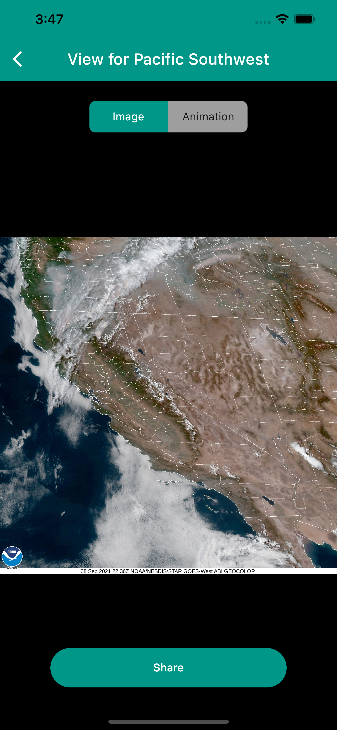
As a professional weather nerd I had to comment on how elegant this app is! When aviationweather.gov updated their website they some how left off the ability to animate the satellite imagery. This app allows you to very quickly and easily get a glimpse of what is going on as recent as 10 minutes ago. I have zero complaints: ) and only one wish. I would love to be able to adjust the animation speed a touch, but this app is brilliant!!! Many Thanks!

Great images

itouch777 on

Соединенные Штаты

Thank you for such a useful app. Nice addition to my other weather apps. Good work!

A peak at what’s available in near real-time imagery

owndao on

Соединенные Штаты

NOAA’s Geostationary Operational Environmental Satellite imagery is so refreshing to see. The constellation of geostationary Earth observation imagers is what is really happening now, not months ago as Google Earth sees fit to refresh theirs. I’m very happy to be able to see the latest snapshot as well as the recent history, shareable as GIFs. Different zones, mainly of the North American continent and surrounding ocean along with coverage of the major ocean routes for cyclonic activity are very welcome to see. A wish list would include infrared for cloud penetration and temperatures, CO2 content, etc.. Ultimately, in an integrated, easily navigable, zoom in view. I realize that this will require a good deal of optical topographical manipulation and downloads with real-time updating will be a major effort and sounds like a remake of Google Earth but the timeliness of this imagery and its lack of the overload of generating pretty yet over-processed old data will make it stand apart. Thank you for creating this. It doesn’t have to be a big money project to allow us all to see in one place us looking back at our world. This is something long overdue.

Оценки

История позиций в топах
Позиции в категории
Рейтинг
Категория
Позиция
Топ бесплатных
183
Топ бесплатных
376

GOES Viewer Конкуренты

Name
Earth++
A 3D climate and event viewer
Waterscope Weather
For people who love water.
Weather Lab
Radar MAX Future Weather Radar
Predictive NOAA Doppler Radar
NOAA Forecast
Highways & Hailstones
Next level storm chasing!
PWS Connect station monitoring
widgets + Watch app + history
Cloud Map
날씨위성영상 라이브
Satellite in the pocket
Durant Weather Radar

GOES Viewer Установки

30дн.

GOES Viewer Доход

30дн.

GOES Viewer Доходы и Загрузки

Получите ценные инсайты о производительности GOES Viewer с помощью нашей аналитики.
Зарегистрируйтесь сейчас, чтобы получить доступ к статистика загрузок и доходов и многому другому.