Map It Vilas County

Разработчик: Pilch & Barnet
Скачивания
Доход

Описание

Explore dozens of public recreational trails in Vilas County, Wisconsin, with this app. Interactive maps help you explore the best spots for snowmobiling, ATVing, biking, hiking, cross-country skiing and more. Find and sort trails by length, location, activities, amenities and more.

Скриншоты

Map It Vilas County Частые Вопросы

  • Приложение Map It Vilas County бесплатное?

    Да, Map It Vilas County полностью бесплатное и не содержит встроенных покупок или подписок.

  • Является ли Map It Vilas County фейковым или мошенническим?

    🤔 Качество приложения Map It Vilas County спорное. Некоторые пользователи довольны, в то время как другие сообщают о проблемах. Рекомендуем ознакомиться с отдельными отзывами для получения более полной картины.

    Спасибо за ваш голос

  • Сколько стоит Map It Vilas County?

    Приложение Map It Vilas County бесплатное.

  • Сколько зарабатывает Map It Vilas County?

    Чтобы получить оценку дохода приложения Map It Vilas County и другие данные AppStore, вы можете зарегистрироваться на платформе мобильной аналитики AppTail.

Оценки пользователей
Приложение еще не оценено в Канада.
История оценок

Map It Vilas County Отзывы Пользователей

This may be the worst app I have ever seen

kokemill on

Соединенные Штаты

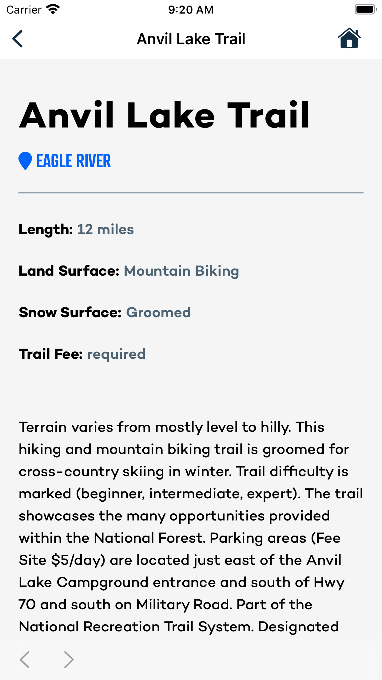
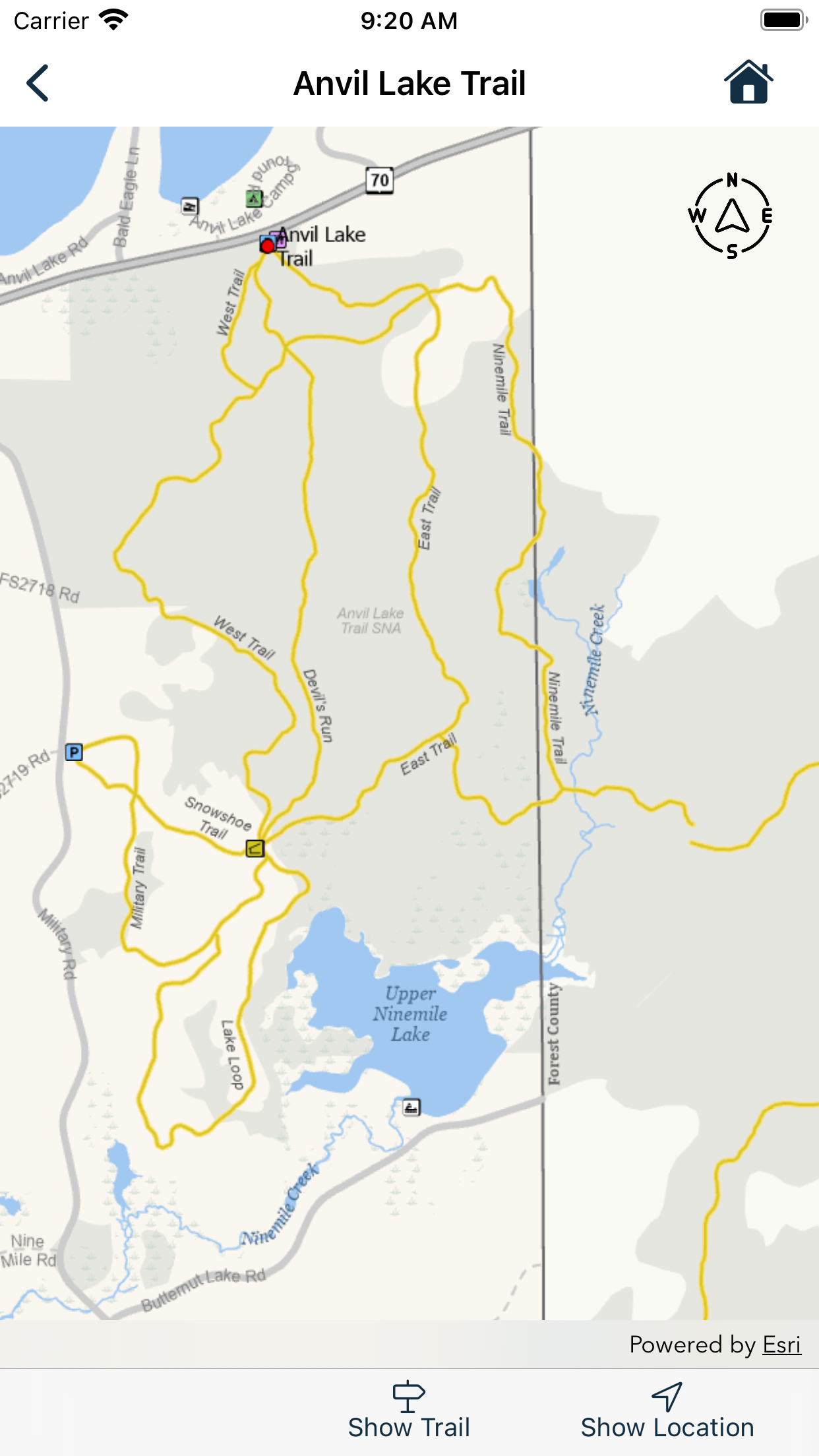
The main map has no legend, and there doesn’t appear to be a way to link from the overall map to the sub maps. They could replace this with a custom google map with a 100% increase in functionality. My wife wants to visit here but I keep thinking that if the people who live here are as stupid as the people the approved the design of this app we are probably better off going somewhere like Alabama. The idea of this app seems useful, tell me the trails that I can come and enjoy. This app is a complete failure.

Useless

HBTA on

Соединенные Штаты

Ditch this junker and put a PDF for download on the Vilas county site. What a waste of data this app is.

Not good

oldelkguy on

Соединенные Штаты

Does not function well ..

Okay, not great

margin5 on

Соединенные Штаты

Was hoping to plan a UTV route but there is no capability for that although the description said so.

Poor

ast4455666 on

Соединенные Штаты

Not very intuitive. Very hard to figure out. App says you can plan a route but where that’s at, I can’t figure out.

My go-to app when I’m up north!

Bri 123454321 on

Соединенные Штаты

I use this app every time I’m in the Northwoods! It’s so fun to be able to explore different trails and communities with each trip. The app is super easy to use and makes me feel much more comfortable trekking into the woods where I’m usually in unfamiliar territory. I get very little reception in the Northwoods so the offline maps are awesome!

Does Not Work ...

Snowshoe Guy on

Соединенные Штаты

When you look at trail information, it claims you need an internet connection when you already have one ... Yet, one can view the interactive map ... Buggy, Do not recommend ... Even reinstalled and installed again ... 👎👎

Love This App!!

Lucy, Lily & Winstons mom on

Соединенные Штаты

I found this app a couple of years ago and used it to try new hiking trails I also use the Gaia app which provided me with miles walked, elevation and more importantly where I was on the trail. After updating the app, I found out that it now shows where you are on the trail. Great feature!!!! I’ve told many people visiting the area about this app. Because it makes them more comfortable on our area trails!

Internet required

Northwoods Enthusiast on

Соединенные Штаты

Can’t access the Trail Info portion using cell data- it requires Internet access. Not always available in the Northwoods.

I wish it worked

JovieCrimson on

Соединенные Штаты

Great idea, but it won’t let me view any trail info.

Оценки

История позиций в топах
История рейтингов пока не доступна
Позиции в категории
Приложение еще не было в топах

Map It Vilas County Конкуренты

Name
BRP GO!: Maps & Navigation
GPS for all powersports
GroomerTracker
Discover Wisconsin
Polaris®
Powered by RIDE COMMAND.
Groomer Tracking Systems
Trail Reports You Can Count On
511 Wisconsin
MKE SmartPark
Ride Sledmass Trails
The Next Trail
Trailz - Let's Ride!
Wisconsin Trail Navigation

Map It Vilas County Установки

30дн.

Map It Vilas County Доход

30дн.

Map It Vilas County Доходы и Загрузки

Получите ценные инсайты о производительности Map It Vilas County с помощью нашей аналитики.
Зарегистрируйтесь сейчас, чтобы получить доступ к статистика загрузок и доходов и многому другому.