Planimeter GPS medida área

medições de campo no mapa

Разработчик: VisTech.Projects

Описание

Planimeter é uma ferramenta para medir a distância, área e perímetro em um mapa. Você pode medir manualmente ou através de rastreamento GPS. Você também pode verificar o rolamento e geo-coordenadas da sua localização e compartilhá-lo. Os pontos podem ser rotulados, salvos e compartilhados em formato KML.

Se você tem alguma dúvida sobre Planimeter e sua funcionalidade, por favor, verifique como usar Guia Rápido:

http://ios.vistechprojects.com/Planimeter_iOS_QuickGuide.pdf

Demonstração em vídeo:
http://youtu.be/unjYbPCIYM0
http://youtu.be/QQMilHVD5e8


Recursos:

distância precisa e cálculo de área
unidades métricas e imperiais (m, km, pés, jardas, milhas, ha, acres)
Ângulo entre linhas
Rolamentos de e para o ponto
Forth e navegação Voltar através de pontos pelo toque em Painel de informações
coordenadas GPS de um ponto
configurações de precisão GPS (se o GPS disponível)
Gerenciar projetos salvas anteriormente: abrir, salvar, compartilhar arquivos KML
KML arquivos criados pelo Planimeter podem ser importados para GEarth e GMaps para a vista em um desktop
Enviar dados por e-mail: imagem, coordenadas como mensagem de texto, arquivo KML
Salvar KML ou TXT no armazenamento local
Mapa / fotografia satélite
pontos de zoom e editar
Pesquisa localização atual
Texto (endereço) pesquisa
Excluir selecionados / últimos / todos os pontos
Zoom para ajustar-in e pontos centrais em uma tela - procurar pontos rápidos
Adicionar pontos pelo toque
Adicionar local atual como ponto
Mostrar localização com coordenadas de latitude e longitude
Adicionar pontos por Geocoordenadas: Lat e de GNL
Opção de último ponto central acrescentou
Opção para exibir / ocultar linhas
Preferências: precisão de localização, rastreamento intervalo de tempo, pontos de confirmação de exclusão, opção de som para rastreamento
configurações de unidades separadas para a distância, área, perímetro
Modo de alvo para uma colocação precisa pin
Mostrar coordenadas atuais no modo alvo
Stylus Desenhe Modo
opção de tela cheia
GPS Tracking
colocação pin manual em GPS Tracking


O aplicativo tem sido usado com sucesso em diferentes áreas:

- atividades ao ar livre: esportes, golfe (distância entre dois pontos ou furos), passeios de bicicleta, planejamento trilha, viajar, medida caminho rápido
- jardim e quintal: Paisagem planejamento, corte de grama, cuidado do gramado e roçada, esgrima, grama semeadura.
- agricultura, aves de capoeira e cultivar: colheita, adubação, culturas (milho, trigo, milho, beterraba, etc.) planeamento e estimativa, medida a área de campo, prados e cercar a área para vacas, cavalos, galinhas, coelhos, etc.
- energia solar: estimativa de área para os painéis solares, telhado plano estimativa de área
- construção: levantamento fundiário, vedação da estrada, estacionamento reparação
- florestais: objetos e mapeamento árvore, estimativa de área de danos, medida área de terra
- outros: lagoas tamanho e são medida; pólo linhas de planejamento; movimento de rastreamento; obter exata GPS coordenadas de maneira pontos; cálculo da cerca; geocaching.

Nota: O uso continuado de GPS funcionando no fundo pode diminuir drasticamente a vida da bateria.

Se você gosta do app e achar que é útil, por favor, ajudem-nos com o seu feedback e comentários.
Não hesite em contactar [email protected] com quaisquer perguntas, comentários ou relatórios de bugs.
Скрыть Показать больше...

Скриншоты

Planimeter GPS medida área Частые Вопросы

  • Приложение Planimeter GPS medida área бесплатное?

    Да, Planimeter GPS medida área полностью бесплатное и не содержит встроенных покупок или подписок.

  • Является ли Planimeter GPS medida área фейковым или мошенническим?

    🤔 Качество приложения Planimeter GPS medida área спорное. Некоторые пользователи довольны, в то время как другие сообщают о проблемах. Рекомендуем ознакомиться с отдельными отзывами для получения более полной картины.

    Спасибо за ваш голос

  • Сколько стоит Planimeter GPS medida área?

    Приложение Planimeter GPS medida área бесплатное.

  • Сколько зарабатывает Planimeter GPS medida área?

    Чтобы получить оценку дохода приложения Planimeter GPS medida área и другие данные AppStore, вы можете зарегистрироваться на платформе мобильной аналитики AppTail.

Оценки пользователей

4.33 из 5

3 оценок в Португалия

5 star
1
4 star
2
3 star
0
2 star
0
1 star
0
История оценок

Planimeter GPS medida área Отзывы Пользователей

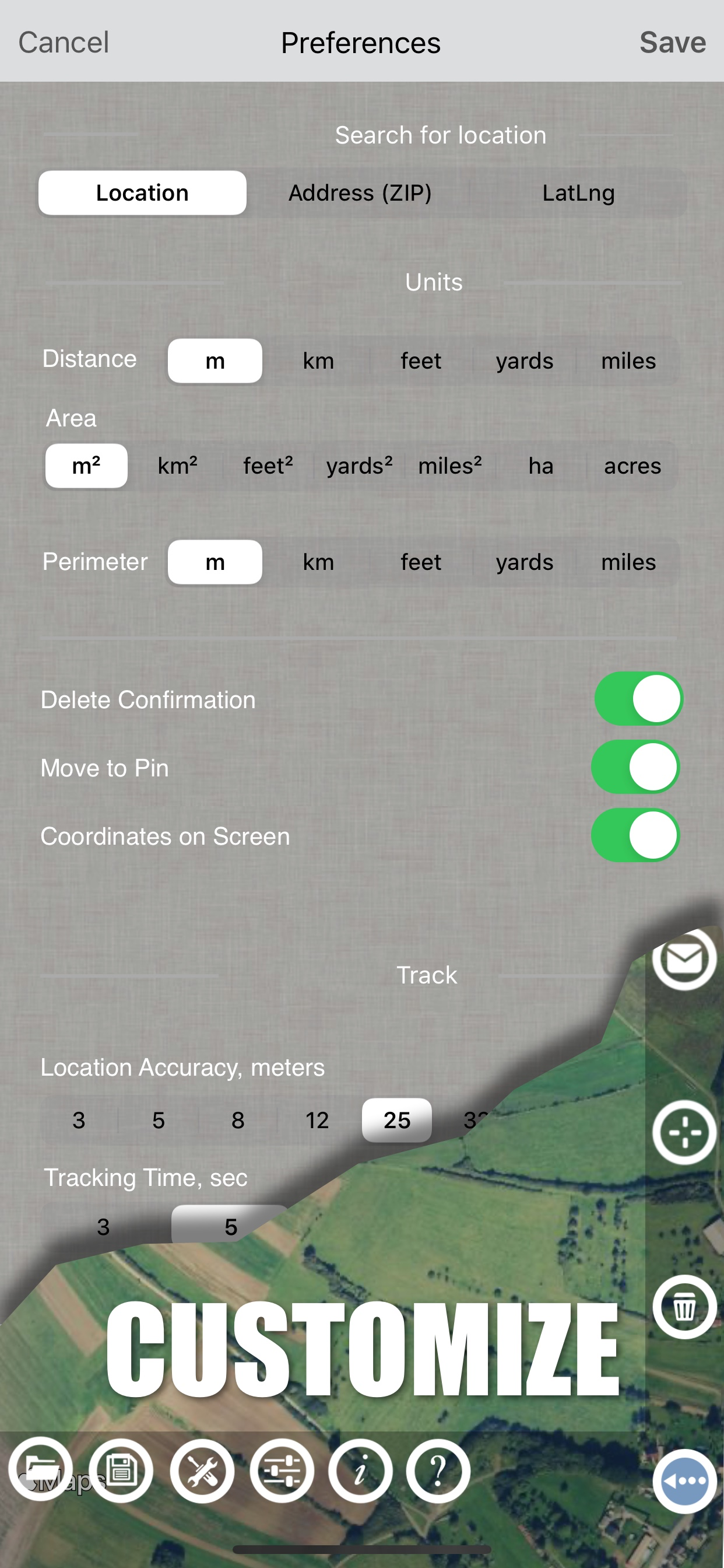
Переход на другой язык

аалгпорпрошгп on

Россия

Как перейти на русский язык в программе

Location

12345 crops on

Соединенные Штаты

Will not use my location

Planimeter

Find a different app to use on

Соединенные Штаты

I save files in the app after measuring acres or plotting points, and when I access the saved file to send to myself, all the points are gone. The file will not let me save to One Drive. The app fails to find my location. I’ve had to uninstall the app, get it from the App Sore again and reinstall, and it still fails to work properly. AGRIplot could be a pain in the rear sometimes, but I never had this much trouble with it.

Great tool

Look below to cancel things on

Соединенные Штаты

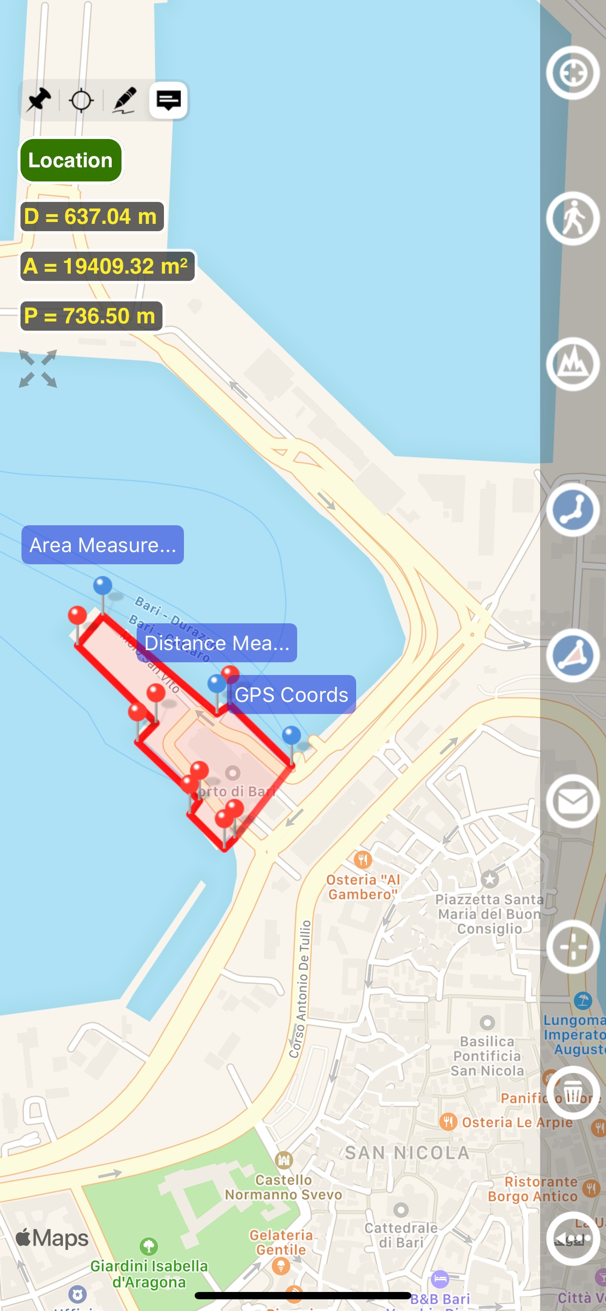
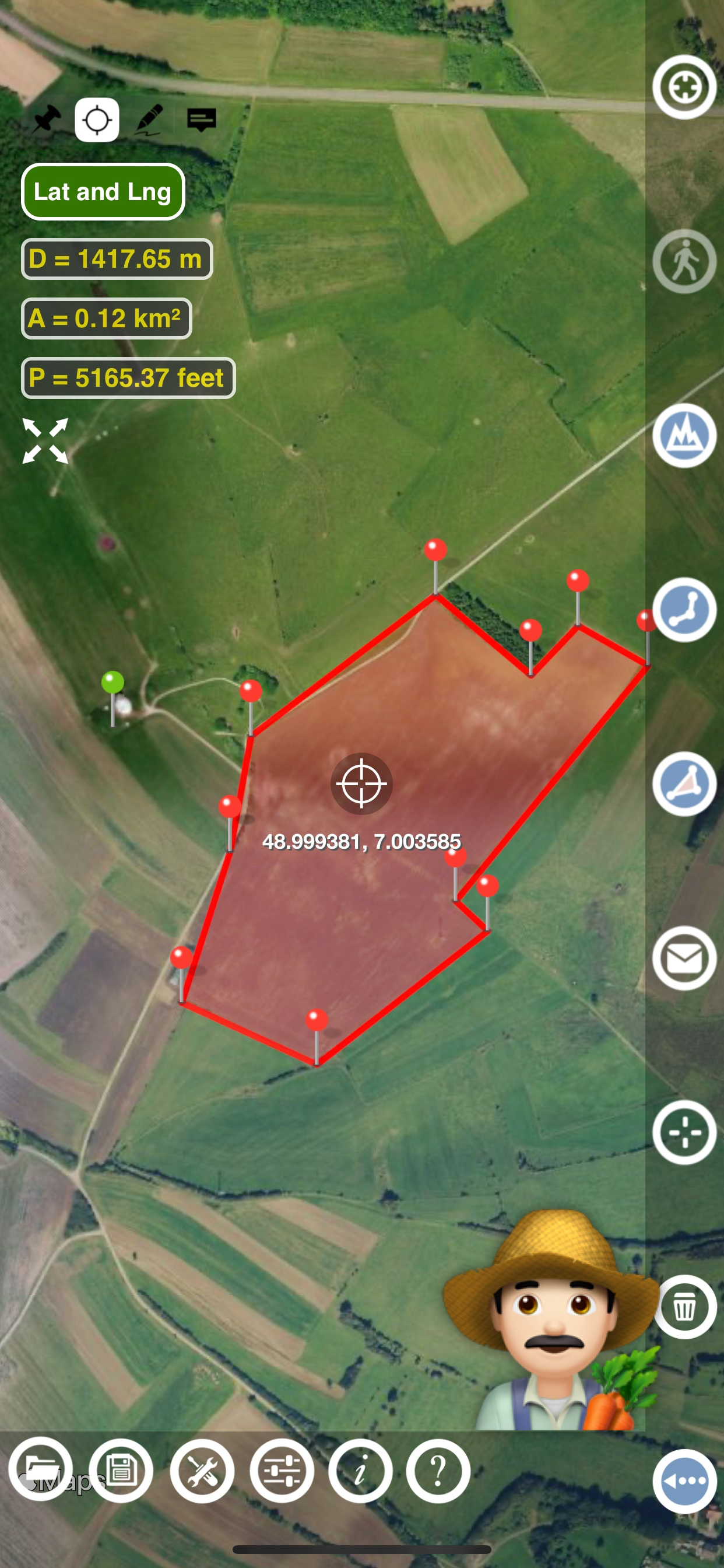
Easy and intuitive to use. Creates nice CSV files to drop into other online tools and align with municipal maps. A big help managing a land project.

Cattle Company Inc

Ranch131 on

Соединенные Штаты

Great app use all the time measuring pastures

Mislead to believe I’d be able to enter dms

vrybdpkt on

Соединенные Штаты

If you have one point you should be able to enter dms and distance and have it plot the next point and so on. It doesn’t allow entering dms from a point so it’s not very useful for finding the area of and edges for a parcel if you don’t already know where they are.

Problemas con el app

Hondero723.. on

Соединенные Штаты

El app no vale la pena se frisa y no permite un buen zoom. Para hacer medidas más exactas es un robo

Convenient

enRub on

Соединенные Штаты

Easy and simple way to measure areas.

Not very good!

Chooch440 on

Соединенные Штаты

Extremely difficult to use. Too hard to accurately place pins. No way to delete or clear all pins. Satellite view is not as good as other measuring apps. It needs a "bullseye" to allow for pin placement. Nice try, but not a keeper. Deleting it now.

Needs work and buggy

Bordwell on

Соединенные Штаты

I see what you’re trying to do, and this could be a handy app. Buggy: I allow location use While Using and it says that I disallowed location. Needs: delete pins, move pins Since I couldn’t move or delete pins, and it doesn’t know where I’m at…. Going to leave it alone. Maybe check in a few times a year to see if it’s any better.

Оценки

История позиций в топах
История рейтингов пока не доступна
Позиции в категории
Рейтинг
Категория
Позиция
Топ платных
20
Топ платных
33
Топ платных
34
Топ платных
47
Топ платных
78

Planimeter GPS medida área Конкуренты

Planimeter GPS Area Measure Установки

30дн.

Planimeter GPS Area Measure Доход

30дн.

Planimeter GPS medida área Доходы и Загрузки

Получите ценные инсайты о производительности Planimeter GPS Area Measure с помощью нашей аналитики.
Зарегистрируйтесь сейчас, чтобы получить доступ к статистика загрузок и доходов и многому другому.

Информация о приложении

Категория
Productivity
Разработчик
VisTech.Projects
Языки
English
Последнее обновление
2.1.15 (5 месяцев назад )
Выпущено
Jul 23, 2014 (10 лет назад )
Обновлено
5 дней назад
This page includes copyrighted content from third parties, shared solely for commentary and research in accordance with fair use under applicable copyright laws. All trademarks, including product, service, and company names or logos, remain the property of their respective owners. Their use here falls under nominative fair use as outlined by trademark laws and does not suggest any affiliation with or endorsement by the trademark holders.