Приложение временно недоступно

Rivers & Seas boat navigation

Inland boat navigation w/ AIS

Разработчик: mediaworx berlin
Скачивания
Доход

Описание

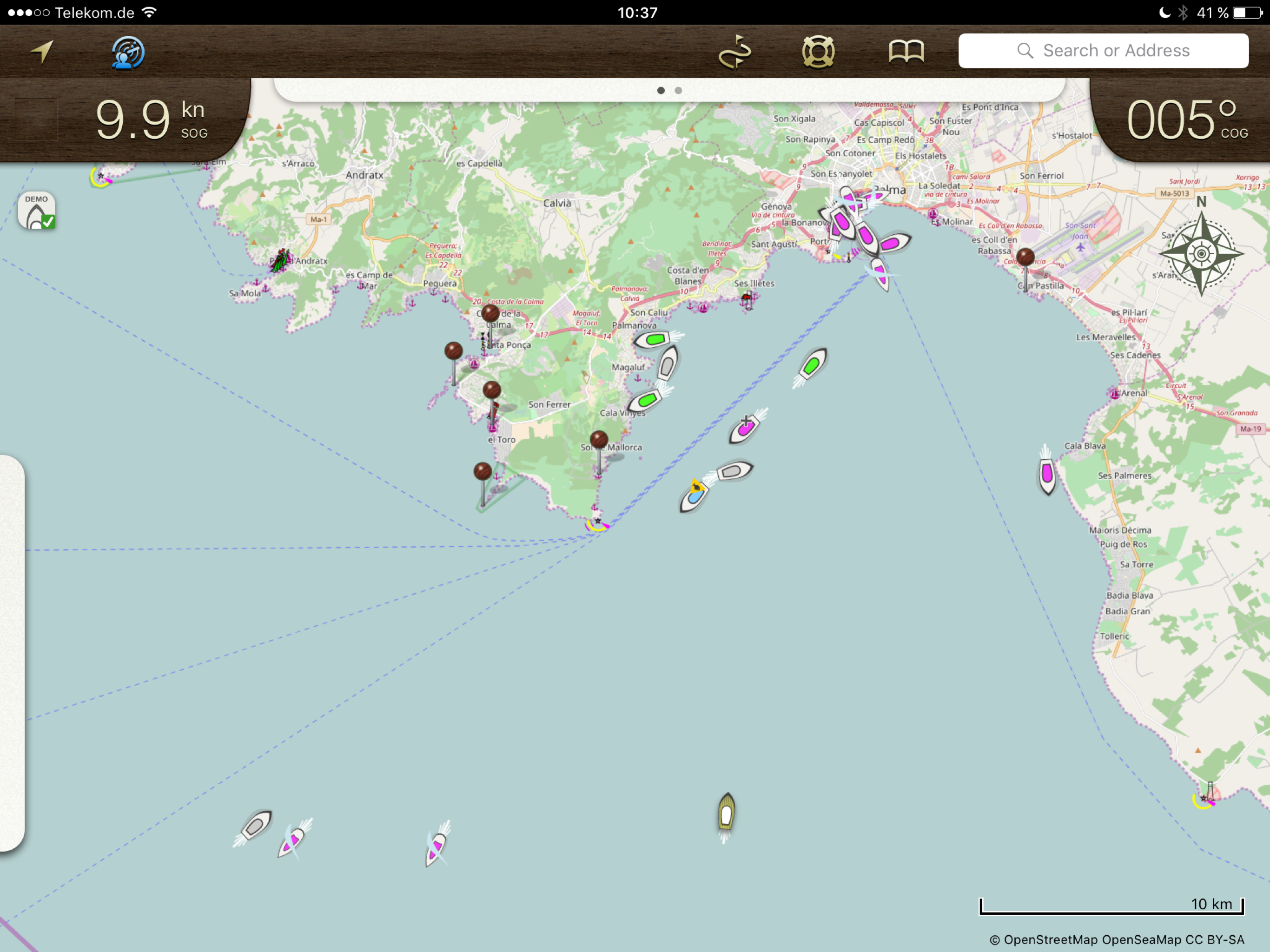
The chart plotter with AIS for inland waters. Rivers & Seas is the iPad navigation system for your boat:

DETAILED WATERS MAPS
Rivers and waterways are listed in detail with buoys, clearances, landmarks, ports and anchorages. In addition landscape, roads and buildings provide orientation. Marinas are shown with piers and service facilities such as gas stations and black water extraction.

AREA GUIDE
VHF channels, phone numbers and opening times of locks and bridges ahead are displayed automatically when driving. You will get a warning if a bridge clearance is too low or a lock will be closed upon arrival.

The display of speed, heading and position also includes the speed limit at the current route segment. Your location is named with river kilometer and name of the river, lake or bay.
SHIP POSITIONS AIS (In App Subscription)
Position of ships with AIS is shown in the map. Ships on the waterway ahead are displayed in the left panel with name , course and speed. No AIS receiver is needed for that.

PLANNED ROUTES
Planned routes can be drawn and used as a guide line for the ride. Rivers & Seas calculates length and travel time of the route. The drawing tool is ideal for routes along winding waterways and chains of lakes.

The planned routes are also ideal on boating holidays for remembering and following the recommendation of a charter basis.

DESTINATIONS AND BOOKMARKS
Rivers & Seas predicts distance and travel time to destinations on the waterway that you mark with pins. The passage time and opening times of locks or bridges are included in the calculation.

OFFLINE MAPS
Routes and areas can be downloaded. Under way or abroad no internet connection is required. Only the areas needed on the route are loaded, without needless land areas.

CLERANCES, OPENING HOURS AND SPEED LIMITS
Bridges and locks on the waterway ahead are displayed in a list with clearances, opening hours, VHF channels and phone numbers along with the distance and remaining driving time to get there. If bridges are to low or locks will be closed upon arrival, a warning is displayed.
FRIENDS RADAR
Even the location of your friends or flotilla is shown in the map. Find anchor position of friends to easily or keep an eye on the distance to the boots of an a convoy with the Friends Radar.
SEARCHING
Search for waters, places, addresses, coordinates and even facilities such as marinas, shops or ATMs.
You will see, Rivers & Seas is the ideal plotter for inland waters. To learn more, visit us at facebook.com/riversandseas or write us at [email protected].

Rivers & Seas is suitable especially for Germany, Netherlands, France, Austria, Switzerland and Baltic Sea, North Sea, Balearic Islands and the Adriatic Sea. The positon of ships in ma (AIS) is useful all over the world.

The map does not show water depths. The display of clearances, speed limits and river kilometer is only available in German and Dutch inland waters.

Rivers & Seas runs on all iPads. The current GPS position can only be displayed on iPads with cellular data. Continued use of GPS running in the background can dramatically decrease battery life. For long-term use of the iPad as a chart plotter a power source is required.
Скрыть Показать больше...

Встроенные покупки

Show ships
699.00₸

Скриншоты

Rivers & Seas boat navigation Частые Вопросы

  • Приложение Rivers & Seas boat navigation бесплатное?

    Да, Rivers & Seas boat navigation можно скачать бесплатно, однако в приложении есть встроенные покупки или подписки.

  • Является ли Rivers & Seas boat navigation фейковым или мошенническим?

    🤔 Качество приложения Rivers & Seas boat navigation спорное. Некоторые пользователи довольны, в то время как другие сообщают о проблемах. Рекомендуем ознакомиться с отдельными отзывами для получения более полной картины.

    Спасибо за ваш голос

  • Сколько стоит Rivers & Seas boat navigation?

    Rivers & Seas boat navigation имеет несколько покупок/подписок внутри приложения, средняя цена покупки составляет 699.00 ₸.

  • Сколько зарабатывает Rivers & Seas boat navigation?

    Чтобы получить оценку дохода приложения Rivers & Seas boat navigation и другие данные AppStore, вы можете зарегистрироваться на платформе мобильной аналитики AppTail.

Оценки пользователей
Приложение еще не оценено в Казахстан.
История оценок

Rivers & Seas boat navigation Отзывы Пользователей

Solala

Skater0912 on

Германия

Mir fehlen die automatischen Steg zu Steg Routenvorschläge nach Eingabe eines Start- und Zielpunktes unter Berücksichtigung der Bootsabmessungen. Das Anlegen einer Route durch Zeichnen der Strecke ist zeitaufwändig und birgt die Gefahr, dass mein Boot aufgrund der Durchfahrtshöhe oder des Tiefgangs dort nicht fahren kann.

Funktioniert wieder….

jockelbaer on

Германия

…nach Löschen und Neuinszallation

Empfehlenswert

Merle7 on

Германия

Die App hat mich gut und zuverlässig durch mehrere Charterreviere in Deutschland geführt und ich bin sehr zufrieden. Von der Planung bis hin zur eigentlichen Fahrt funktioniert alles und bietet auf einer Seite übersichtlich alle wichtigen Informationen. @ Team, es wäre schön, wenn man die Schrift in der Grösse einstellen könnte, da ich mir diese gerne etwas grösser Anzeigen lassen würde.

Schade ums Geld

Bhl4382 on

Германия

Die App funktioniert leider überhaupt nicht. Die Ortung ist sehr ungenau, die Geschwindigkeit wird vorsorglich gar nicht angezeigt. Absolut nutzlose App!! 😩

Routenplaner

HaniJG8 on

Германия

Ich nutze diese App schon länger und bin sehr zufrieden. Meine Frage an Euch Entwickler. Könnte man nicht eine Art Routenplaner integrieren? Man gibt die Marina, GPS-Koordinaten oder erkennt automatisch die Position, wo das Boot (sich die App befindet) liegt, als Startposition ein und dann eine Marina oder GPS-Koordinaten für die Zielposition ein. Dann müsste die App den Weg und eine ungefähre Zeit berechnen und Alternativrouten noch anbieten, wenn man nicht durch eine Stadt durchfahren will. Bei Fahrt mit der App könnte dann die Geschwindigkeit des Bootes in die Präzisierung der Ankunftszeit einfließen. Gut wäre dabei eine Aufstellung über Anzahl der Schleusen (mit Öffnungszeiten) und anderen wichtigen See-Bauwerken (Brücken - Öffnungszeiten, etc.) zu haben. Was auch gut wäre, wenn man ein Seezeichen mit dem Finger antippt, dass dort in einem separaten Fenster eine Erklärung mit Standort und anderen wichtigen Informationen angezeigt wird. Denkt man darüber nach. Das wäre ein Novum und würde die Popularität Eurer App noch steigern. Wenn Ihr das hinbekommt, dass wäre der absolute Hammer. Danke.

Seekarte ohne tiefen

Gironimoo on

Германия

Leider gibt es keine tiefenangaben ——NICHT kaufen

Super App - leider nicht auf iPad OS 14

AZP on

Германия

Die App hat uns in der Vergangenheit gute Dienste geleistet, ist übersichtlich und einfach zu bedienen. Umso schmerzhafter, dass sie nun nicht mehr unter iPadOS 14 läuft. Ich hoffe, das ist bis zum Sommer gefixt (dann gibt‘s auch die verdienten 5 Sterne)

Super Begleitung!!

Strom 63 on

Германия

Hallo an das River&Seas Team! Ich war 14 Tage in den Brandenburgischen Gewässern unterwegs und eure App hat mich super begleitet. Meine erste unfreiwillige Nachtfahrt habe ich dank eurer App gut bewältigen können. Was echt toll ist, dass ihr die Stellnetze vermerkt habt. Große Hilfe gewesen!!! Die App ist echt eine Supersache! Weiter so 😁

Läuft bestens (iPadAir 1)

WaveDiver24 on

Германия

Wie schon im Titel zu lesen benutze ich die App mit dem iPad Air 1 (cellular) die Rechenleistung reicht absolut für die App. Das Laden der offlinekarten dauert zwar recht lange, aber so oft lädt man sich ja auch nicht neue Strecken (ich jedenfalls nicht) Der Support vom Entwickler ist auch super. Schnelle kompetente Antworten. Was ich mir noch wünsche wäre eine Art Logbuch in der App. Dort könnte man Notizen zum Kraftstoffverbrauch oder zur Strecke machen. Vielleicht sehen die Entwickler das ja auch so... Ich kann die App jedenfalls nur empfehlen !

Für mich leider nicht zu gebrauchen

astertel on

Германия

Die Bedienung der App ist verbesserungswürdig. Teilweise weiße Schrift auf hellem Hintergrund, nicht lesbar. Langsamer Aufbau der Seite. Bin sehr enttäuscht und werde mich nach einer anderen Lösung umsehen. Wollte die Probleme über meinen Apple Account dem App Entwickler mitteilen, wurde hierbei auf eine Facebook Seite weitergeleitet und habe daraufhin aufgegeben.

Ключевые слова

Rivers & Seas boat navigation Конкуренты

Name
NV Charts GPS Navigation AIS
Marine Navigation and Boating
Camping Log
logge deine Camping-Erlebnisse
Port-Guide
Der Hafenführer für unterwegs.
Helmsman's Kit
i-Boating:Germany Marine Chart
Lake Fishing Maps & Navigation
Tide Prediction
River Levels
Pegel für Binnenschifffahrt
KartenWerft NavGo 2.0
Skippers Log
The logbook for your yacht
ChargeOne Partner

Rivers & Seas Установки

30дн.

Rivers & Seas Доход

30дн.

Rivers & Seas boat navigation Доходы и Загрузки

Получите ценные инсайты о производительности Rivers & Seas с помощью нашей аналитики.
Зарегистрируйтесь сейчас, чтобы получить доступ к статистика загрузок и доходов и многому другому.