Airmate
Flight planning/weather
#1 Keyword Rankings
Today
Top 10 Rankings
Today
Top 30 Rankings
Today
Top 100 Rankings
Today

Description

Airmate is a free and easy to use Electronic Flight Bag for pilots, providing help for flight planning and navigation, improving situational awareness and providing social sharing features.

Thanks to Airmate EFB flight planning tools, you will get instant access to airport data and aviation maps worldwide, up to date weather and NOTAMs, traffic around, and you could even file a flight plan.

IFR and VFR airport diagrams and plates are freely available in US (FAA charts), all Europe, and more than 200 other countries. Most of them are georeferenced and could be overlaid on the aviation chart. A powerful Plate Manager allows to download in advance all airport plates in a country, they could be easily printed and viewed.

During the flight, the moving map will display the aircraft location along the route, show airports and aeronautical data details, show traffic around and warn you if your planned route is crossing restricted areas. A profile view is available to display terrain elevation, crossed areas and forecasted weather across the route. Airmate can also display a backup aircraft attitude indicator and flight parameters in an EFIS-like view using the device internal sensors or a supported external AHRS-capable ADS-B receiver or supported aircraft avionics. In the whole world, Synthetic Vision displaying in the EFIS-like view the ups and downs of rolling terrain ahead is available.

Airmate includes a worldwide aeronautical database updated free of charge with airports, navigation beacons, waypoints, airways, obstacles, regulated and restricted areas. Topographic maps and elevation data for most countries may be downloaded free of charge, as well as additional aviation map overlays such US Sectionals. A procedure database provide details of departure (SID), arrival (STAR) and instrument approaches in specific countries, and you could add those procedures to your planned flight route (the procedure database includes all US airports, and many RNP approaches in other countries). Once loaded, the procedure path is displayed on the aeronautical map, including curved paths and racetracks.

When coupled with a supported external ADS-B received, Airmate will display nearby traffic on the moving map, and receive FIS-B weather and NOTAM during the flight. To improve safety, Airmate can display neighbouring traffic received over mobile network. Such traffic include commercial airlines and transponder-equiped aircrafts, FLARM gliders, aircrafts whose pilots are using Airmate and other users using other safety broadcasting equipment.

Airmate is able to transmit the flight plan data to and receive flight parameters and AHRS data from supported avionics such Dynon SkyView.

Thanks to the Auto Route feature, you could search and select the best route for your flight, and then file your flight plan anywhere in the world.

Airmate will also record your flights and allow to replay them later or export the flight path in gpx format. Pilot log entries are automatically computed from flown flights.

A Satellite map display mode in flight planning or replay mode allows to familiarize with significant landmarks.

Airmate will save planned and flown flights, user waypoints and user aircrafts in the cloud and sync them between your devices and Airmate web flight planning.

Airmate brings numerous social features to the community. Pilots may leave ratings, tips and comments to share their experience with fellow pilots, and report fuel prices and landing fees. They could find friends, instructors, flight schools, aviation events and aircraft to rent near their home airport or any visited airport.

Airmate may be connected to most flight simulators to keep flying skills sharp. Planned flights and personal waypoints may be imported and exported, including from/to flight simulators.

Continued use of GPS running in the background can dramatically decrease battery life.
Terms of Use: https://www.apple.com/legal/internet-services/itunes/dev/stdeula/
Hide.. Show more..

In-Apps

Airmate Premium
29,99 €
Airmate Pro version
24,99 €
Turkey 2024 Rogers Data
89,99 €
Flight plan filing token
1,99 €
Belgium DFS VFR 2019 Chart
24,99 €
Belgium DFS VFR 2021 Chart
24,99 €
French Cartabossy Map 2018
29,99 €
Belgium-LU 2021 Rogers Data
29,99 €
Belgium-LU 2022 Rogers Data
34,99 €
Support Airmate development!
5,99 €

Screenshots

User Rating

4.5 out of 5

48 ratings in Belgium

5 star
27
4 star
18
3 star
3
2 star
0
1 star
0

Ratings History

Reviews

Great free app

Eurojet145 on

Great application. Needs some fine tuning to be perfect. Like able to change the track more easily when in fly mode. Frequencies should be visible in the vertical mode.

Very nice

TOGA_03 on

The free version is awesome

Très sympathique

cassigneul on

Très bonne application en simulateur

Very nice app

hpirzt on

Always margin for improvement to become as good as payware apps but the development team stands open to discuss further improvement

Great VFR nav app

Adrien.houdart on

Works great on my iPhone 8 and on my iPad mini 4. I had to change the map engine in the app to « New Raster » to work properly on my iPad mini 4 as advised by the developers. Good job!

Convivial

N341GG on

En avion,Ulm,ou Helico un outil convivial

Air magnifique

Trouillard on

Simple, intuitif, très complet, gratuit, fiable, clair...

Truly amazing for a free app !

BajaB on

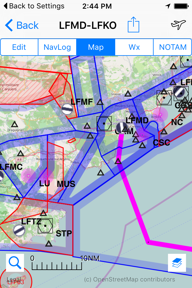
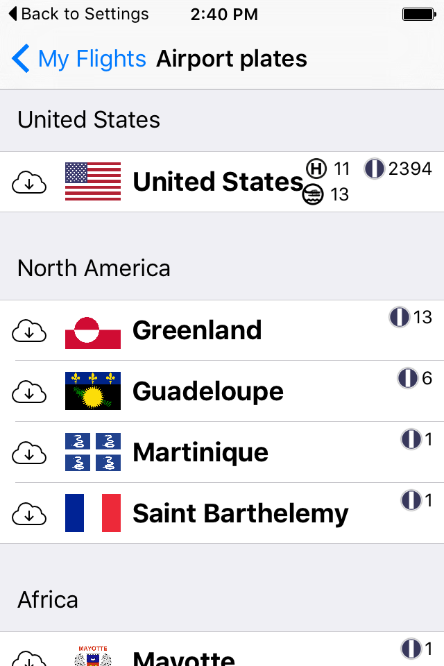
Planning a flight to Senegal, I discovered this app which covers all of the countries I will cross; several countries that SkyDemon ignores. Airport plates, NOTAM, Restricted zones, ... you name it !

Store Rankings

Ranking History

Category Rankings

Chart
Category
Rank
Top Grossing
5
Top Grossing
31
Top Grossing
35
Top Grossing
62
Top Grossing
77

Keywords

Users may also like

Name
FlyQ EFB
Direct-To Aviation GPS VFR IFR
Air Navigation for Pilots
NOTAM Briefing (VFR/IFR)
Your preflight NOTAM check
SkyDemon
Air Navigation Pro
The Pilot Assistant
AeroChart
Aeronautical Charts
SafeSky
FlyGo Air Navigation
Aviation App for Pilots
Navigraph Charts
Jeppesen FliteDeck Pro
Show More

Revenue and Downloads

Gain valuable insights into Airmate performance with our analytics. Sign up now to access downloads, revenue, and more.

App Info

Category
Navigation
Publisher
Myriel Aviation SA
Languages
Spanish, German, French, English, Italian, Portuguese, Russian
Recent version
3.16 (6 days ago )
Released on
Oct 17, 2016 (7 years ago )
Last updated
3 weeks ago