Airmate
Flight planning/weather
#1 Keyword Rankings
Today
Top 10 Rankings
Today
Top 30 Rankings
Today
Top 100 Rankings
Today

Description

Airmate is a free and easy to use flight planning and weather app for pilots, improving situational awareness and providing instant access to airport data and aviation maps, up to date weather and NOTAMs, traffic around.

IFR and VFR airport plates are freely available in US (FAA charts), Europe, and more than 200 other countries. Many of them are georeferenced and could be overlaid on the aviation chart. A powerful Plate Manager allows to download in advance all airport plates in a country, they could be easily printed and viewed.

During the flight, the moving map will display the aircraft location along the route, show airports and aeronautical data details and traffic around, warn you if your planned route is crossing restricted areas. A profile view is available to display terrain elevation, crossed areas and forecasted weather across the route. Airmate can also display a backup aircraft attitude indicator and flight parameters in an EFIS-like view. In the whole world, Synthetic Vision displaying in the EFIS-like view the ups and downs of rolling terrain ahead is available. In selected countries, Airmate can display scenery if this option is purchased.

Airmate includes a worldwide aeronautical database updated free of charge with airports, navigation beacons, waypoints, airways, obstacles, regulated and restricted areas. Topographic maps and elevation data for most countries may be downloaded free of charge, as well as additional aviation map overlays such US Sectionals. A procedure database provide details of departure (SID), arrival (STAR) and instrument approaches in the USA, and you could add those procedures to your planned flight route (the procedure database includes all US airports, we are workding to add airports in other countries). Once loaded, the procedure path is displayed on the aeronautical map, including curved paths and racetracks.

When coupled with a supported external ADS-B received, Airmate will display nearby traffic on the moving map, and receive FIS-B weather and NOTAM during the flight. To improve safety, Airmate can display neighbouring traffic received over mobile network. Such traffic include commercial airlines and transponder-equiped aircrafts, FLARM gliders, aircrafts whose pilots are using Airmate and other users using other safety broadcasting equipment.

Airmate is able to transmit the flight plan data to supported avionics such Dynon SkyView.

Thanks to the Auto Route feature, you could search and select the best route for your flight, and then file your VFR or IFR flight plan. Once filed, your flight plan could easily be managed, delayed or cancelled.

Airmate will also record your flights and allow to replay them later or export the flight path in gpx format, you could take pictures from the app during flights. Pilot log entries are automatically computed from flown flights.

A Satellite map display mode in flight planning or replay mode allows to familiarize with significant landmarks.

Airmate will save planned and flown flights, user waypoints and user aircrafts in the cloud and sync them between your devices and Airmate web flight planning.

Airmate brings social features to the community. Pilots may leave ratings, tips and comments to share their experience with fellow pilots, and report fuel prices and handling fees. They could find friends, instructors, flight schools, aviation events and aircraft to rent near their home airport or any visited airport. A planned flight may be shared with other pilots by indicating the number of seats available for additional passengers.

Airmate may be connected to most flight simulators to keep flying skills sharp, and will manage also AHRS and simulated traffic data transmitted by the flight simulator. Planned flights and personal waypoints may be imported and exported.

Continued use of GPS running in the background can dramatically decrease battery life.
Terms of Use: https://www.apple.com/legal/internet-services/itunes/dev/stdeula/
Hide.. Show more..

In-Apps

Airmate Premium
$24.99
Airmate Pro version
$22.99
Flight plan filing token
$1.99
Support Airmate development!
$17.99
Token for 1 year chart access
$3.99
DFS Germany VFR Airport Plates
$54.99
Skyguide Swiss VFR Airport Plates (with one year updates)
$36.99
Avioportolano VFR Airfield Plates for Italy (one year subscription)
$46.99

Screenshots

User Rating

4.48 out of 5

428 ratings in United States

5 star
315
4 star
60
3 star
20
2 star
8
1 star
25

Ratings History

Reviews

Crashes when you use certain departures.

Tj1170 on

If devs are reading, select KPIE runway 36 as departure and it will crash the app. Tried two different devices and same result. I tried different SIDs but they all crash it.

Not Intuitive

Cardsrule63126 on

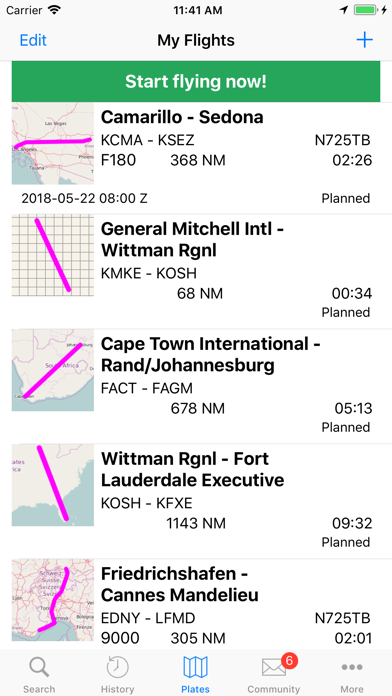
30 year pilot and could not get a route loaded and displayed. Looks like has a lot of great features just have to figure out access them.

Good but still buggy

GrapeDr1nk on

Good app, but still a bit buggy… (F.e. Not being able to scroll down in the summary page when creating a flight, among a couple other weird ones like incorrect distance to fuel usage calculations.) But overall, pretty good app.

Great aviation app

Shook montana on

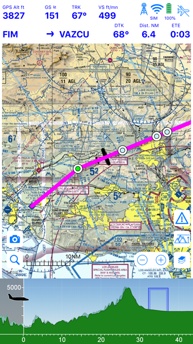
I fly VFR in the Rocky Mountains of Western Montana and Northern Idaho. This app works great, easy to use, accurate, consistently updated and it’s free! What more could you ask for! I give it 5 stars!

Great app for navigation and charts

SWIFT TRIPS on

Best aviation app

Where are the sectionals?

notputtingupwithapplebull on

I am trying to plan a 900 mile cross country flight. The only sectional I see is the New York sectional. I’ve written for help and get no response.

Best (Free) Flight Planning Software on the Market

B R Frost on

I typically use this to plan routes in Microsoft Flight Simulator. However, that does not stop its superior accuracy and ability to achieve what i want it to. Highly recommend this app if you do not wish to pay for a monthly subscription to other applications of the same quality(i.e. ForeFlight, Garmin Pilot, etc. Overall a very good free flight planner that is a must for any aviation enthusiast, simulator pilot or professional.

A bit buggy but works in a pinch

Crimguy on

It’s pretty decent. I’ve experienced a few crashes and loading up all sectionals has resulted in my iPad freezing a lot. But it gets the job done overall.

Great app

Full555 on

Good back up to have

Good but has flaws

(AlexC) on

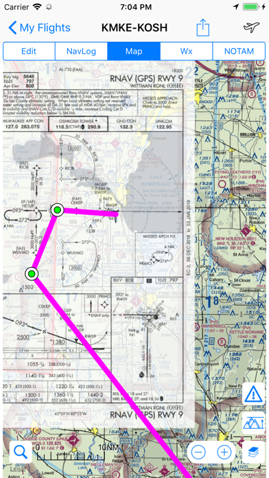
The airports are unsearchable under the Edit tab for the “From” and “To” entry boxes. Does suffer from occasional crashes.

Store Rankings

Ranking History

App Ranking History not available yet

Category Rankings

Chart
Category
Rank
Top Grossing
5
Top Grossing
31
Top Grossing
35
Top Grossing
62
Top Grossing
77

Keywords

Users may also like

Name
OzRunways EFB
Flight Planner, EFB & GPS
FltPlan Go for iPhone
Direct-To Aviation GPS VFR IFR
Air Navigation for Pilots
NOTAM Briefing (VFR/IFR)
Your preflight NOTAM check
SDVFR
SkyDemon
Air Navigation Pro
The Pilot Assistant
AeroChart
Aeronautical Charts
FlyGo Air Navigation
Aviation App for Pilots
Navigraph Charts
Show More

Revenue and Downloads

Gain valuable insights into Airmate performance with our analytics. Sign up now to access downloads, revenue, and more.

App Info

Category
Navigation
Publisher
Myriel Aviation SA
Languages
Portuguese, German, Spanish, French, English, Italian, Russian
Recent version
3.16 (6 days ago )
Released on
May 27, 2016 (8 years ago )
Last updated
4 weeks ago