Antonine Wall
#1 Keyword Rankings
Today
Top 10 Rankings
Today
Top 30 Rankings
Today
Top 100 Rankings
Today
Description
This application allows you to explore, and learn more about, the Antonine Wall, part of the Frontiers of the Roman Empire World Heritage Site. The Antonine Wall was a turf defence built by the Romans around 142 AD, across the central belt of Scotland. Today, there are a number of forts and fortlets, a bathhouse, and impressive remains of the ditches and banks within easy reach of towns and railway stations. Download the app and experience 360° virtual reconstructions, ‘handle’ 3D models of artefacts, and explore the sites along the Wall - even from your armchair!
Features:
* Explore the Antonine Wall in the landscape
* GPS navigation with alert for nearby points of interest
* Augmented Reality: view of POIs in the landscape through the camera module, alternative navigation, 2D image recognition for certain POIs
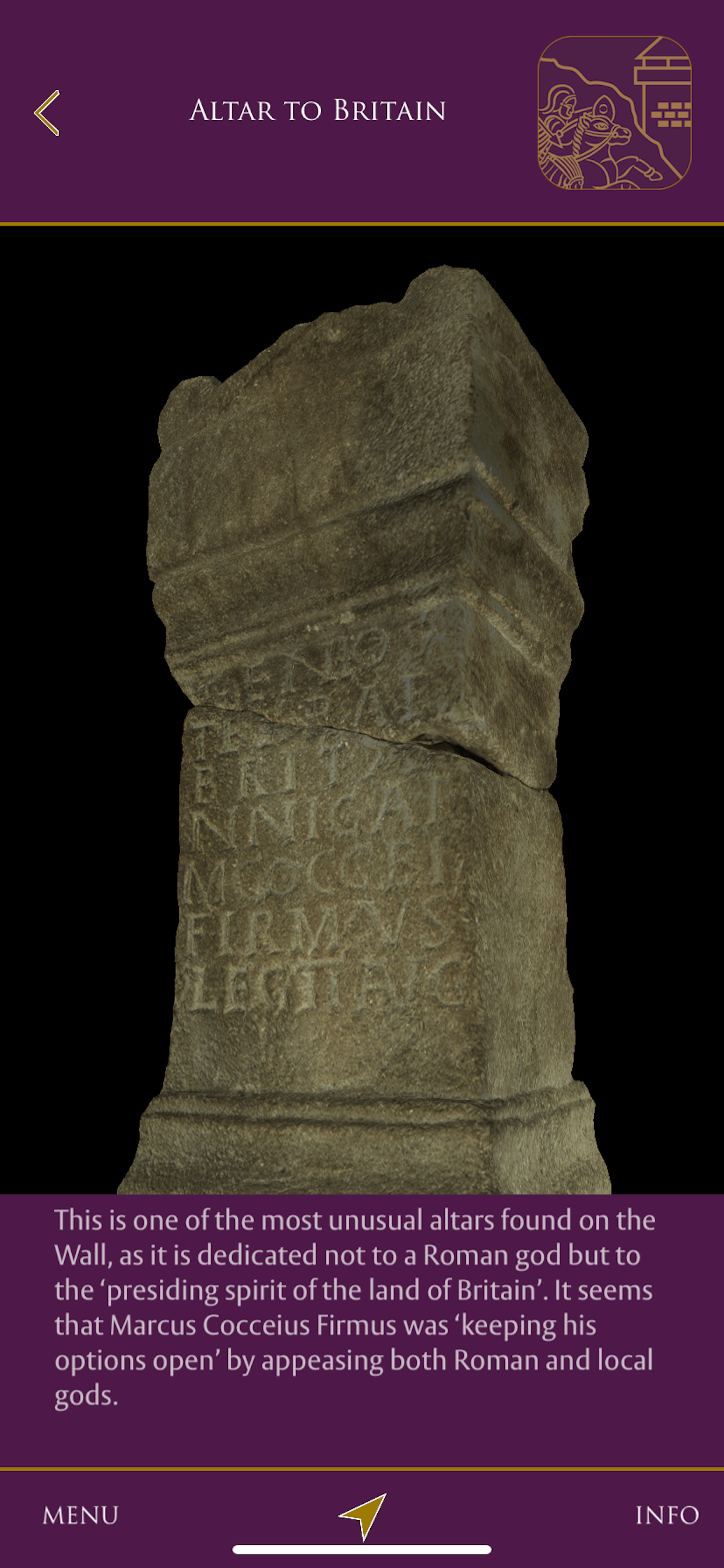
* Discover and ‘handle’ 3D objects and models
* View 360° virtual reconstructions
* Download maps and contents to your phone for easy offline usage
* Automatic updates as new sites and content are added
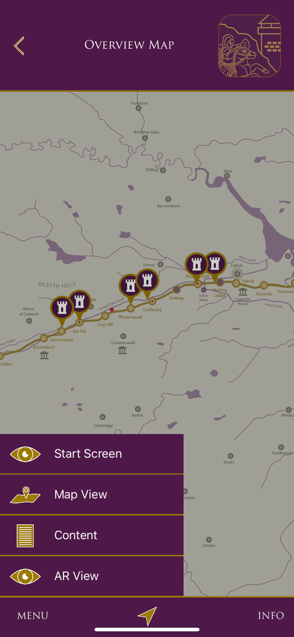
The zoomable OSM map data provides easy access to the content. Both maps and content are available offline (internet connection is not mandatory). Clickable Points Of Interest on the maps start the content on request. 3D models, 360 views, video and audio sequences as well as text-/picture information are provided. An integrated GPS navigation with an alert guides you to the sites. An alternative list view shows you the available content.
Currently content is available for the Roman fort at Bar Hill. Subsequently more sites along the line of the Antonine Wall will be added.
The project is co-funded by the Creative Europe programme.
Project partners are:
* Historic Environment Scotland (Scotland)
* Landesstelle für nichtstaatliche Museen in Bavaria (Bavaria)
* CDDV – Centre for Digital Documentation and Visualisation (Scotland)
* edufilm und medien GmbH (Austria)
Thanks go to:
*Bayerische Sparkassenstiftung (the Bavarian Savings Bank Foundation) for funding the original app platform.
*The Hunterian Museum, Glasgow for providing access to the artefacts from the Antonine Wall in their collections.
*Local authority Partners and funders: West Dunbartonshire Council, Glasgow City Council, East Dunbartonshire Council, North Lanarkshire Council, and Falkirk Council.
The application is available for free.
Hide..
Show more..
Features:
* Explore the Antonine Wall in the landscape
* GPS navigation with alert for nearby points of interest
* Augmented Reality: view of POIs in the landscape through the camera module, alternative navigation, 2D image recognition for certain POIs
* Discover and ‘handle’ 3D objects and models
* View 360° virtual reconstructions
* Download maps and contents to your phone for easy offline usage
* Automatic updates as new sites and content are added
The zoomable OSM map data provides easy access to the content. Both maps and content are available offline (internet connection is not mandatory). Clickable Points Of Interest on the maps start the content on request. 3D models, 360 views, video and audio sequences as well as text-/picture information are provided. An integrated GPS navigation with an alert guides you to the sites. An alternative list view shows you the available content.
Currently content is available for the Roman fort at Bar Hill. Subsequently more sites along the line of the Antonine Wall will be added.
The project is co-funded by the Creative Europe programme.
Project partners are:
* Historic Environment Scotland (Scotland)
* Landesstelle für nichtstaatliche Museen in Bavaria (Bavaria)
* CDDV – Centre for Digital Documentation and Visualisation (Scotland)
* edufilm und medien GmbH (Austria)
Thanks go to:
*Bayerische Sparkassenstiftung (the Bavarian Savings Bank Foundation) for funding the original app platform.
*The Hunterian Museum, Glasgow for providing access to the artefacts from the Antonine Wall in their collections.
*Local authority Partners and funders: West Dunbartonshire Council, Glasgow City Council, East Dunbartonshire Council, North Lanarkshire Council, and Falkirk Council.
The application is available for free.
Screenshots


 User Rating
5 out of 5
1 ratings in United States
5 star
1
4 star
0
3 star
0
2 star
0
1 star
0
Ratings History
Reviews
Store Rankings
Ranking History
App Ranking History not available yet
Category Rankings
App is not ranked yet
Keywords
Users may also like
| Name | Reviews | Recent release | |
|---|---|---|---|
Hadrian's Wall
|
1
|
3 years ago | |

French Polynesia Travel Guide
|
0
|
7 years ago | |

French Polynesia Offline Map a
|
0
|
7 years ago | |

Bamberg Beer Guide
A Beer Drinker's Guide
|
1
|
1 year ago | |

Pompeii Touch
|
11
|
11 months ago | |

Amsterdam Maps & Routes
Amsterdam Discovery Challenge
|
3
|
5 years ago | |

Aberdeen Map and Walks
|
0
|
6 years ago | |

Walker for Garmin
|
0
|
3 years ago | |

Atlas: Castles and History
Plan a trip or virtually visit
|
5
|
1 year ago | |

Dunnottar Castle
|
0
|
8 years ago |
Show More
Revenue and Downloads
Gain valuable insights into Antonine Wall performance with our analytics. Sign up now
to
access downloads, revenue, and more.
App Info
- Category
- Travel
- Publisher
- edufilm und medien Ges.mbH
- Languages
- German, English
- Recent version
- 1.3.3 (3 months ago )
- Released on
- Sep 24, 2016 (7 years ago )
- Also available in
- United Kingdom, Germany, United States, France, Singapore, Sweden, Saudi Arabia, Russia, Pakistan, Thailand, Philippines, Turkey, India, Peru, Nigeria, Mexico, Kazakhstan, South Korea, Japan, Argentina, Israel, Hungary, Hong Kong, Finland, Czechia, Colombia, China, Chile, Canada, Belarus, Belgium, Azerbaijan
- Last updated
- 3 weeks ago