DecaMaps
#1 Keyword Rankings
Today
Top 10 Rankings
Today
Top 30 Rankings
Today
Top 100 Rankings
Today
Description
Créer une grande carte détaillée à la fois!
+++++ Caractéristiques +++++
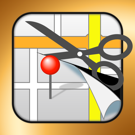
- DecaMaps est une application pour iPhone et iPad pour créer une grande carte détaillée.
Vous pouvez créer une carte originale uniquement par 2 marches.
Etape 1. Décider une zone sur la carte.
Étape 2. Appuyez sur le bouton ciseaux.
La zone que vous choisissez est rapidement établi une grande carte détaillée.
- Facile preview
Vous n'avez pas besoin de zoomer ou dézoomer sur la carte. Votre iPhone ou iPad vous montre une grande carte et une carte détaillée sur le même écran.
- Imprimer une grande carte!
Vous pouvez imprimer une grande affiche jusqu'à 16 feuilles de papier.
* Format de papier pris en charge: A4/Letter/B4/B5
* Achat d'une "grande copie d'affiche add-on" pour imprimer un plus de 4 feuilles de papier (2 feuilles x 2 feuilles). (Ad sera supprimée si vous achetez l'add-on.)
* Pour imprimer des affiches, vous avez besoin d'une imprimante compatible AirPrint avec sur le même réseau Wi-Fi connecté avec appareil iOS.
- Vous pouvez également enregistrer la carte à la caméra Roll.
Jusqu'à 26.000.000 carte de pixels peut être enregistré comme un fichier image.
* Bei Angabe von Camera Roll, können gespeicherte Bild nicht genug vergrößern, aber das ursprüngliche Bild nicht verarmt.
Enregistrez l'image sur votre PC et de le voir ou voir avec une application iPhone qui prend en charge les images à haute résolution.
+++++ "DecaMaps" est utile pour +++++
Si vous imprimez sur une grande carte par vous-même, il est très utile pour les situations ci-dessous.
- Confirmer l'endroit où vous n'êtes jamais allé auparavant.
- Pour les pré-confirmation de la destination ou l'utilisation comme un guide de voyage
- Imprimez les endroits où vous avez été ou ont grandi et profiter de la vue de leur
- Pour une carte d'évacuation, un assistant retour plan de maison
- Pour une carte de conduite
- Pour vérifier un parcours scolaire pour votre enfant / enfants
- Pour un événement, une présentation de conférences
[English]
--------------------------------------------------------------------------
Create a large detailed map at once!
+++++ features +++++
- DecaMaps is an iPhone and iPad app to create a large detailed map.
You can create an original map only by 2 steps.
Step1. Decide an area on the map.
Step2. Tap the scissor button.
The area you choose is quickly drawn a large detailed map.
- Easy preview
You do not need to zoom in or out to the map. Your iPhone or iPad shows you a large map and a detailed map on the same screen.
- Print a large map!
You can print out a large poster up to 16 sheets of paper.
*Supported paper size: A4/Letter/B4/B5
*Purchase a “large poster print add-on” to print a more than 4 sheets of paper (2 sheets x 2 sheets). (Ad will be removed if you purchase the add-on.)
*To print posters, you need a printer that is compatible with AirPrint on the same Wi-Fi network connected with iOS device.
- You can also save the map to Camera Roll.
Up to 26,000,000 pixel map can be saved as an image file.
*On specification of Camera Roll, saved image cannot zoom in enough, but the original image does not become depleted.
Save the image to your PC and see it or view with an iPhone app that supports with high resolution image.
+++++ "DecaMaps" is useful for +++++
If you print out a large map by yourself, it is very useful for below situations.
- Confirm the place where you have never been before.
- For pre-confirmation of travel destination or use as a travel guidebook
- Print out the places where you have been to or have grown up and enjoy the sight of them
- For an evacuation map, an assistant return home map
- For a driving map
- For check a school route for your child/children
- For an event, a lecture presentation
Hide..
Show more..
+++++ Caractéristiques +++++
- DecaMaps est une application pour iPhone et iPad pour créer une grande carte détaillée.
Vous pouvez créer une carte originale uniquement par 2 marches.
Etape 1. Décider une zone sur la carte.
Étape 2. Appuyez sur le bouton ciseaux.
La zone que vous choisissez est rapidement établi une grande carte détaillée.
- Facile preview
Vous n'avez pas besoin de zoomer ou dézoomer sur la carte. Votre iPhone ou iPad vous montre une grande carte et une carte détaillée sur le même écran.
- Imprimer une grande carte!
Vous pouvez imprimer une grande affiche jusqu'à 16 feuilles de papier.
* Format de papier pris en charge: A4/Letter/B4/B5
* Achat d'une "grande copie d'affiche add-on" pour imprimer un plus de 4 feuilles de papier (2 feuilles x 2 feuilles). (Ad sera supprimée si vous achetez l'add-on.)
* Pour imprimer des affiches, vous avez besoin d'une imprimante compatible AirPrint avec sur le même réseau Wi-Fi connecté avec appareil iOS.
- Vous pouvez également enregistrer la carte à la caméra Roll.
Jusqu'à 26.000.000 carte de pixels peut être enregistré comme un fichier image.
* Bei Angabe von Camera Roll, können gespeicherte Bild nicht genug vergrößern, aber das ursprüngliche Bild nicht verarmt.
Enregistrez l'image sur votre PC et de le voir ou voir avec une application iPhone qui prend en charge les images à haute résolution.
+++++ "DecaMaps" est utile pour +++++
Si vous imprimez sur une grande carte par vous-même, il est très utile pour les situations ci-dessous.
- Confirmer l'endroit où vous n'êtes jamais allé auparavant.
- Pour les pré-confirmation de la destination ou l'utilisation comme un guide de voyage
- Imprimez les endroits où vous avez été ou ont grandi et profiter de la vue de leur
- Pour une carte d'évacuation, un assistant retour plan de maison
- Pour une carte de conduite
- Pour vérifier un parcours scolaire pour votre enfant / enfants
- Pour un événement, une présentation de conférences
[English]
--------------------------------------------------------------------------
Create a large detailed map at once!
+++++ features +++++
- DecaMaps is an iPhone and iPad app to create a large detailed map.
You can create an original map only by 2 steps.
Step1. Decide an area on the map.
Step2. Tap the scissor button.
The area you choose is quickly drawn a large detailed map.
- Easy preview
You do not need to zoom in or out to the map. Your iPhone or iPad shows you a large map and a detailed map on the same screen.
- Print a large map!
You can print out a large poster up to 16 sheets of paper.
*Supported paper size: A4/Letter/B4/B5
*Purchase a “large poster print add-on” to print a more than 4 sheets of paper (2 sheets x 2 sheets). (Ad will be removed if you purchase the add-on.)
*To print posters, you need a printer that is compatible with AirPrint on the same Wi-Fi network connected with iOS device.
- You can also save the map to Camera Roll.
Up to 26,000,000 pixel map can be saved as an image file.
*On specification of Camera Roll, saved image cannot zoom in enough, but the original image does not become depleted.
Save the image to your PC and see it or view with an iPhone app that supports with high resolution image.
+++++ "DecaMaps" is useful for +++++
If you print out a large map by yourself, it is very useful for below situations.
- Confirm the place where you have never been before.
- For pre-confirmation of travel destination or use as a travel guidebook
- Print out the places where you have been to or have grown up and enjoy the sight of them
- For an evacuation map, an assistant return home map
- For a driving map
- For check a school route for your child/children
- For an event, a lecture presentation
In-Apps
- Remove Ads
- 0,99 €
- Large poster print(more than 4 sheets)
- 2,99 €
- Large poster print(more than 4 sheets) and Remove Ads
- 3,99 €
Screenshots


 User Rating
0 out of 5
0 ratings in France
Ratings History
Reviews
App doesn't have any reviews yet
Store Rankings
Ranking History
App Ranking History not available yet
Category Rankings
App is not ranked yet
Keywords
Users may also like
| Name | Reviews | Recent release | |
|---|---|---|---|

OSM sketch
|
0
|
11 months ago | |
MyGIS
Your Navigation Companion
|
0
|
6 months ago | |

Secured GPS Logger
Store your location locally.
|
0
|
1 week ago | |

地点メモ
地図上に複数地点を一括表示!
|
0
|
1 month ago | |
Assist Maps
favoris dans le dossier, tache
|
1
|
2 years ago | |

Around Useful Navigaiton
App helps searching places.
|
0
|
6 months ago | |

mémo de carte ma position
latitude, longitude, notes sur
|
0
|
2 years ago | |

MAP COLLECTION diground
Create & Share your own MAP
|
0
|
2 months ago | |

マチカシ江戸東京
マチカシ江戸東京
|
0
|
2 years ago | |
Dual Map -Use maps more freely
Don't get lost anymore
|
0
|
2 years ago |
Show More
Revenue and Downloads
Gain valuable insights into でかマップ performance with our analytics. Sign up now
to
access downloads, revenue, and more.
App Info
- Category
- Navigation
- Publisher
- MEDIANAVI,Inc.
- Languages
- English, Japanese
- Recent version
- 1.2.2 (7 years ago )
- Released on
- May 15, 2013 (11 years ago )
- Also available in
- Japan, United States, Vietnam, Turkey, Thailand, United Kingdom, Canada, China, Colombia, Poland, Germany, Mexico, United Arab Emirates, Kazakhstan, Kuwait, Italy, Israel, Malaysia, Netherlands, Peru, Pakistan, Portugal, Romania, Singapore, South Africa, Hong Kong, Belarus, Switzerland, Brazil, Denmark, Dominican Republic, Azerbaijan, Australia, Algeria, Austria, Ecuador, Egypt, Spain, Finland, Ireland, France, Greece, Belgium, Argentina, Sweden, Saudi Arabia, Russia, Czechia, Philippines, New Zealand, Norway, Nigeria, South Korea
- Last updated
- 1 week ago