Aqua Map Boating
Marine navigation and fishing
#1 Keyword Rankings
Today
Top 10 Rankings
Today
Top 30 Rankings
Today
Top 100 Rankings
Today
Description
FREE 14-day trial on ALL subscriptions.
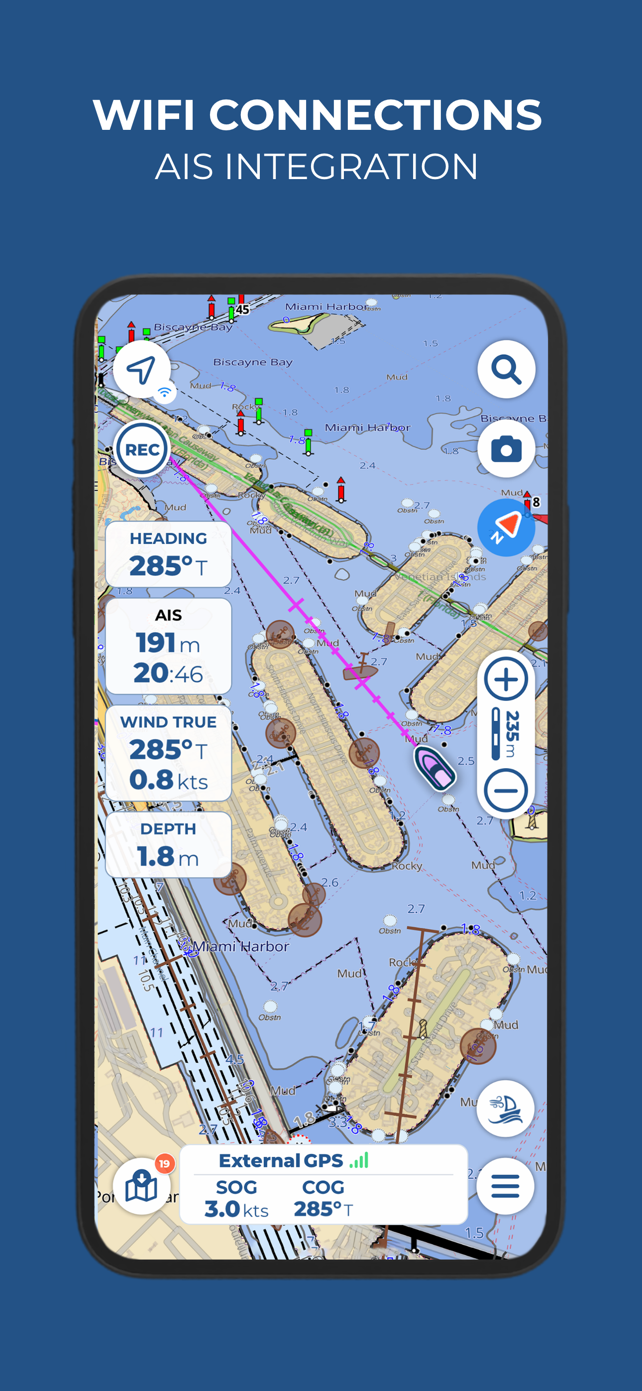
Get the latest charts you can use offline, weather, tides and ActiveCaptain Points of Interest. Connect AIS and your boat instruments data via WiFi. Plan routes, record your tracks, follow your friends and share your data across devices or the community with Live Sharing.
THE MOST ADVANCED MARINE NAVIGATION APP
• Optimised for both iPhone and iPad with iPad multi-screen mode
• Latest vector and raster nautical charts for offline use, updated regularly
• Satellite imagery
• Routes/Tracks navigation with real-time information on bridges, hazards, and best fuel prices
• Easy manual route planning
• Basic anchor alarm and advanced AnchorLink with mirroring and email/telegram notifications
• Marine Forecasts for wind, waves, currents, gust, salinity, sea surface temperature + worldwide weather info
• Easy sharing and uploading of tracks, markers and routes
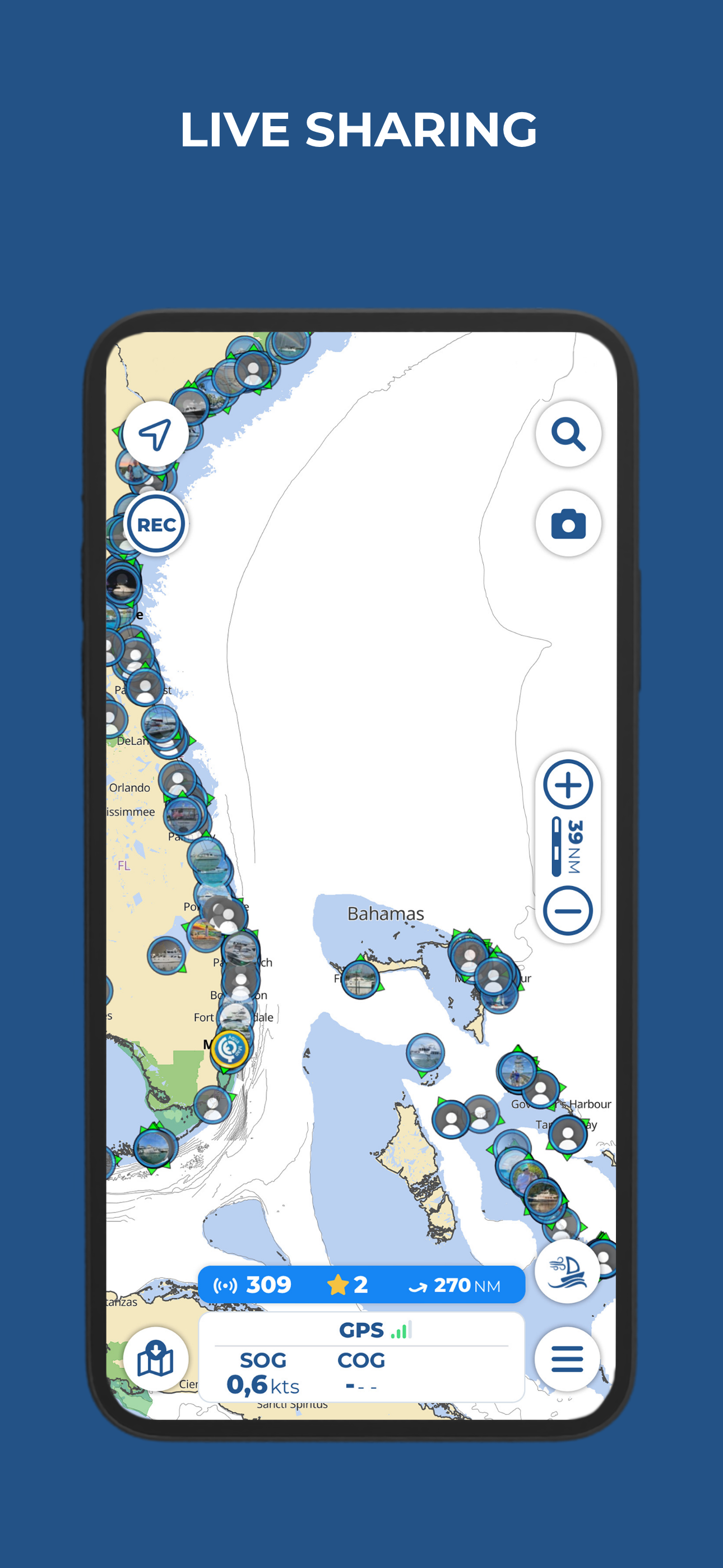
• Live Sharing-Aqua Map community to find new friends on the water
• ActiveCaptain and Waterway Guide community integration
• Real time display of NMEA instruments (autopilot, depth sounder, wind sensor, compass, GPS)
• AIS target display with automatic collision detection
• Powerful search with advanced settings
• Light/Dark display
• Optimised battery usage
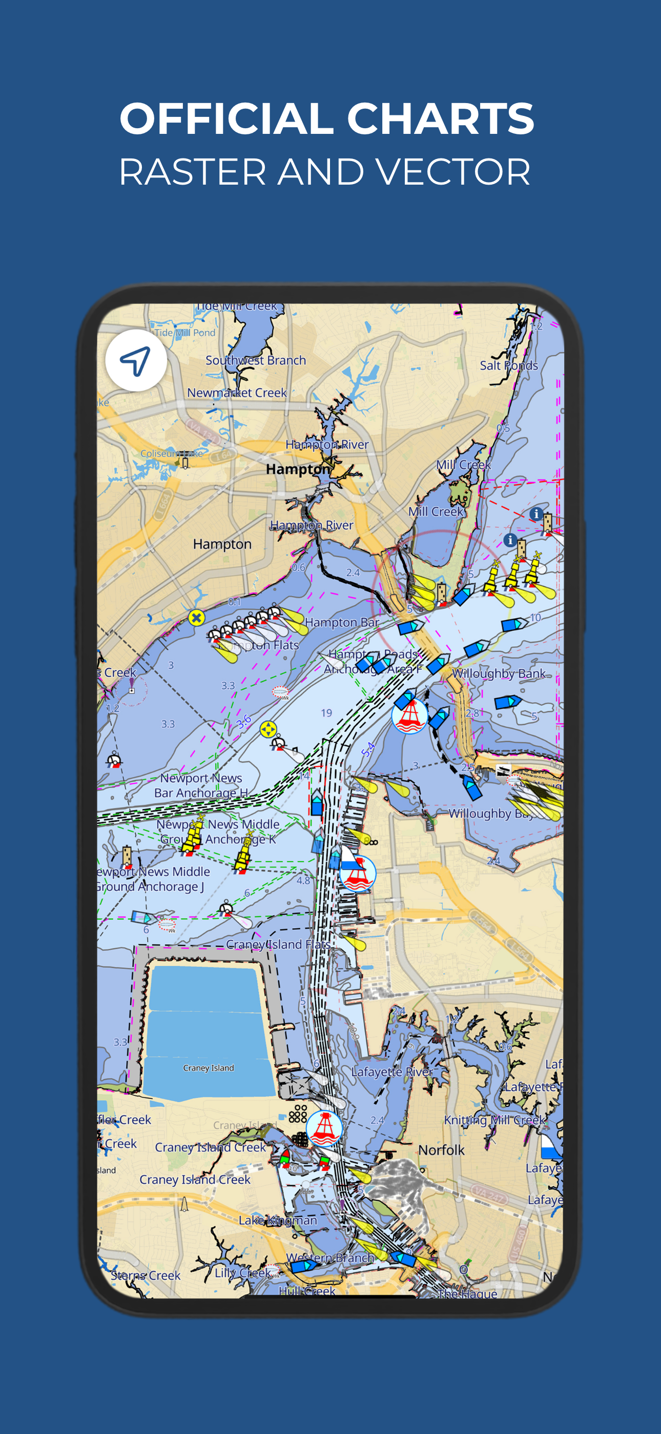
► NAUTICAL CHARTS
Aqua Map uses only official vector and raster Nautical charts complete with depth contours, navigation markers, buoys, lights and other chart features.You can download the maps at home on all your devices and use them on the boat offline (no internet connection required).
► ROUTES, WAYPOINTS AND TRACKS
Plan your route, insert and edit waypoints. Navigate your route and record your track, monitor distance, time (ETA), course and heading to next waypoint or your final destination.
► ANCHOR ALARM
Advanced setup to let you set your anchor position and drift radius. Monitors in real time your GPS position against the defined drift area. An acoustic alarm will sound and a visual alarm be displayed when your GPS position is outside the defined range. There’s also a low battery alarm and a bad GPS reception alarm.
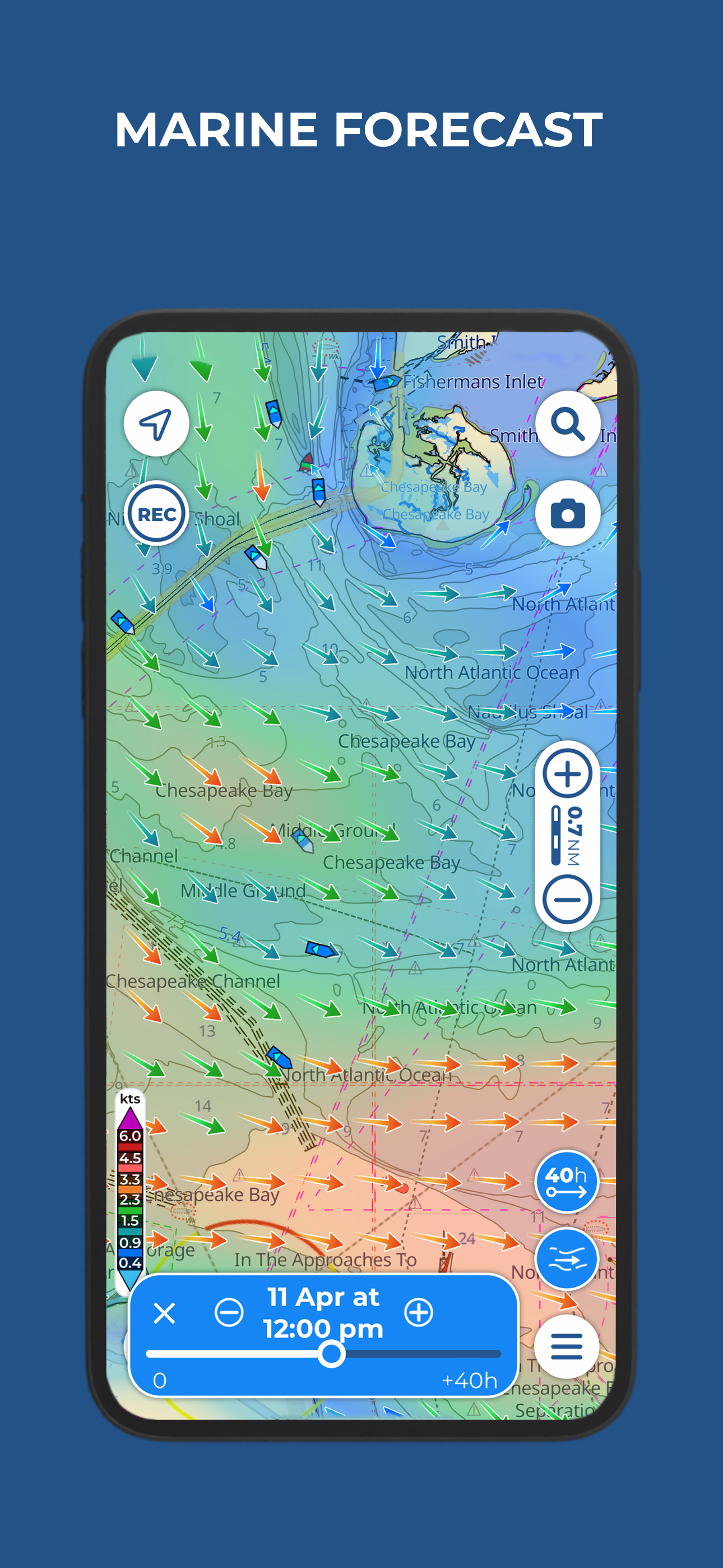
► TIDES AND MARINE FORECASTS
Get currents, wind and waves forecasts as overlay onto the chart with a time slider.
► LOADING and SHARING
Share your favorite markers on Facebook or send an email with your last daily track. Load KML, KMZ, GPX (including zip files).
► LIVE SHARING
Share your data with the Aqua Map community, follow your friends and see all active users around you. Chat, send and receive routes/tracks/markers.
► ACTIVECAPTAIN and WATERWAY GUIDE
Access tens of thousands of points of interests and reviews across UK, Ireland and all over the world. Join the community of boaters who write reviews, update data and provide up to date hazard information.
► AQUA MAP MASTER
Transform your device into a chartplotter with Aqua Map Master:
• AnchorLink with mirroring and email/telegram notifications
• Full marine forecasts (weather + wind, waves, currents, gust, salinity, sea surface temperature).
• Connect NMEA (and SignalK) devices through WiFi.
• Display AIS targets on the chart with automatic collision detection.
• Make route planning easier with Route Explorer automatically finding anchorages, bridges and marinas close to your route.
► TYPE OF PURCHASES
Subscription: one year auto-renewable subscription. The payment will be made through your (Apple ID) account. The subscription will renew automatically unless cancelled at least 24 hours before the expiration. The user can manage their subscription and turn off auto-renewal in the Apple ID Account Settings section after purchase.
Terms of Service: https://www.aquamap.app/terms-and-conditions
Privacy Policy: https://www.aquamap.app/privacy-policy
Hide..
Show more..
Get the latest charts you can use offline, weather, tides and ActiveCaptain Points of Interest. Connect AIS and your boat instruments data via WiFi. Plan routes, record your tracks, follow your friends and share your data across devices or the community with Live Sharing.
THE MOST ADVANCED MARINE NAVIGATION APP
• Optimised for both iPhone and iPad with iPad multi-screen mode
• Latest vector and raster nautical charts for offline use, updated regularly
• Satellite imagery
• Routes/Tracks navigation with real-time information on bridges, hazards, and best fuel prices
• Easy manual route planning
• Basic anchor alarm and advanced AnchorLink with mirroring and email/telegram notifications
• Marine Forecasts for wind, waves, currents, gust, salinity, sea surface temperature + worldwide weather info
• Easy sharing and uploading of tracks, markers and routes
• Live Sharing-Aqua Map community to find new friends on the water
• ActiveCaptain and Waterway Guide community integration
• Real time display of NMEA instruments (autopilot, depth sounder, wind sensor, compass, GPS)
• AIS target display with automatic collision detection
• Powerful search with advanced settings
• Light/Dark display
• Optimised battery usage
► NAUTICAL CHARTS
Aqua Map uses only official vector and raster Nautical charts complete with depth contours, navigation markers, buoys, lights and other chart features.You can download the maps at home on all your devices and use them on the boat offline (no internet connection required).
► ROUTES, WAYPOINTS AND TRACKS
Plan your route, insert and edit waypoints. Navigate your route and record your track, monitor distance, time (ETA), course and heading to next waypoint or your final destination.
► ANCHOR ALARM
Advanced setup to let you set your anchor position and drift radius. Monitors in real time your GPS position against the defined drift area. An acoustic alarm will sound and a visual alarm be displayed when your GPS position is outside the defined range. There’s also a low battery alarm and a bad GPS reception alarm.
► TIDES AND MARINE FORECASTS
Get currents, wind and waves forecasts as overlay onto the chart with a time slider.
► LOADING and SHARING
Share your favorite markers on Facebook or send an email with your last daily track. Load KML, KMZ, GPX (including zip files).
► LIVE SHARING
Share your data with the Aqua Map community, follow your friends and see all active users around you. Chat, send and receive routes/tracks/markers.
► ACTIVECAPTAIN and WATERWAY GUIDE
Access tens of thousands of points of interests and reviews across UK, Ireland and all over the world. Join the community of boaters who write reviews, update data and provide up to date hazard information.
► AQUA MAP MASTER
Transform your device into a chartplotter with Aqua Map Master:
• AnchorLink with mirroring and email/telegram notifications
• Full marine forecasts (weather + wind, waves, currents, gust, salinity, sea surface temperature).
• Connect NMEA (and SignalK) devices through WiFi.
• Display AIS targets on the chart with automatic collision detection.
• Make route planning easier with Route Explorer automatically finding anchorages, bridges and marinas close to your route.
► TYPE OF PURCHASES
Subscription: one year auto-renewable subscription. The payment will be made through your (Apple ID) account. The subscription will renew automatically unless cancelled at least 24 hours before the expiration. The user can manage their subscription and turn off auto-renewal in the Apple ID Account Settings section after purchase.
Terms of Service: https://www.aquamap.app/terms-and-conditions
Privacy Policy: https://www.aquamap.app/privacy-policy
In-Apps
- Aqua Map Master
- ฿499.00
- France - charts
- ฿689.00
- Mexico - West coast
- ฿2,490.00
- Atlantic France - charts
- ฿409.00
- Northern France - charts
- ฿409.00
- Norway - Nautical charts
- ฿799.00
- StrikeLines HardBottomHD
- ฿22,990.00
- Iceland - nautical charts
- ฿699.00
- Cape Verde - Nautical charts
- ฿499.00
Screenshots


 User Rating
3.5 out of 5
2 ratings in Thailand
5 star
0
4 star
1
3 star
1
2 star
0
1 star
0
Ratings History
Reviews
Store Rankings
Ranking History
Category Rankings
|
Chart
|
Category
|
Rank
|
|---|---|---|
|
Top Grossing
|

|
19
|
|
Top Grossing
|

|
22
|
|
Top Grossing
|

|
31
|
|
Top Grossing
|

|
43
|
|
Top Grossing
|

|
47
|
Keywords
Users may also like
| Name | Reviews | Recent release | |
|---|---|---|---|

iNavX: Marine Navigation
Sailing & Boating Chartplotter
|
1
|
1 day ago | |

Navionics® Boating
Nautical and fishing charts
|
13
|
2 days ago | |

C-MAP: Boating
Charts, Planning & Navigation
|
3
|
6 hours ago | |

i-Boating: Marine Charts & Gps
Lake Maps & Fishing Spots
|
0
|
1 month ago | |

Atlas Nautical Charts
Marine & Lakes GPS Charts
|
0
|
1 year ago | |

savvy navvy: Boat Navigation
GPS Charts Tide Weather AIS
|
0
|
13 hours ago | |
PRO CHARTS - Marine Navigation
|
1
|
8 months ago | |

ActiveCaptain®
Connect to Your GPS Plotter
|
3
|
2 days ago | |

TZ iBoat – Marine Navigation
Boat GPS, Charts, AIS, Tides
|
0
|
3 weeks ago | |
Dockwa
Dock and mooring reservations
|
0
|
1 week ago |
Show More
Revenue and Downloads
Gain valuable insights into Aqua Map Boating performance with our analytics. Sign up now
to
access downloads, revenue, and more.
App Info
- Category
- Navigation
- Publisher
- GEC s.r.l.
- Languages
- English, French, Italian, Dutch, Portuguese, Spanish, German
- Recent version
- 41.0 (1 day ago )
- Released on
- Oct 15, 2014 (9 years ago )
- Also available in
- United States, Canada, Italy, Germany, Brazil, United Kingdom, New Zealand, France, Spain, Australia, Netherlands, Austria, Belgium, Argentina, Switzerland, United Arab Emirates, South Africa, Portugal, Ireland, Mexico, Czechia, Sweden, Indonesia, Poland, Hungary, Norway, Romania, Malaysia, China, India, Russia, Hong Kong, Thailand, Denmark, Egypt, Saudi Arabia, Philippines, Chile, Pakistan, Turkey, Colombia, Finland, Vietnam, Algeria, Singapore, Azerbaijan, Taiwan, Ukraine, Belarus, Peru, Nigeria, Lebanon, Kazakhstan, Kuwait, South Korea, Japan, Israel, Greece, Dominican Republic, Ecuador
- Last updated
- 2 weeks ago