Aqua Map Boating
Marine navigation and fishing
#1 Keyword Rankings
Today
Top 10 Rankings
Today
Top 30 Rankings
Today
Top 100 Rankings
Today

Description

FREE 14-day trial on ALL subscriptions.

Get the latest charts you can use offline, weather, tides and ActiveCaptain Points of Interest. Connect AIS and your boat instruments data via WiFi. Plan routes, record your tracks, follow your friends and share your data across devices or the community with Live Sharing.

THE MOST ADVANCED MARINE NAVIGATION APP
• Optimised for both iPhone and iPad with iPad multi-screen mode
• Latest vector and raster nautical charts for offline use, updated regularly
• Satellite imagery
• Routes/Tracks navigation with real-time information on bridges, hazards, and best fuel prices
• Easy manual route planning
• Basic anchor alarm and advanced AnchorLink with mirroring and email/telegram notifications
• Marine Forecasts for wind, waves, currents, gust, salinity, sea surface temperature + worldwide weather info
• Easy sharing and uploading of tracks, markers and routes
• Live Sharing-Aqua Map community to find new friends on the water
• ActiveCaptain and Waterway Guide community integration
• Real time display of NMEA instruments (autopilot, depth sounder, wind sensor, compass, GPS)
• AIS target display with automatic collision detection
• Powerful search with advanced settings
• Light/Dark display
• Optimised battery usage

► NAUTICAL CHARTS
Aqua Map uses only official vector and raster Nautical charts complete with depth contours, navigation markers, buoys, lights and other chart features.You can download the maps at home on all your devices and use them on the boat offline (no internet connection required).

► ROUTES, WAYPOINTS AND TRACKS
Plan your route, insert and edit waypoints. Navigate your route and record your track, monitor distance, time (ETA), course and heading to next waypoint or your final destination.

► ANCHOR ALARM
Advanced setup to let you set your anchor position and drift radius. Monitors in real time your GPS position against the defined drift area. An acoustic alarm will sound and a visual alarm be displayed when your GPS position is outside the defined range. There’s also a low battery alarm and a bad GPS reception alarm.

► TIDES AND MARINE FORECASTS
Get currents, wind and waves forecasts as overlay onto the chart with a time slider.

► LOADING and SHARING
Share your favorite markers on Facebook or send an email with your last daily track. Load KML, KMZ, GPX (including zip files).

► LIVE SHARING
Share your data with the Aqua Map community, follow your friends and see all active users around you. Chat, send and receive routes/tracks/markers.

► ACTIVECAPTAIN and WATERWAY GUIDE
Access tens of thousands of points of interests and reviews across UK, Ireland and all over the world. Join the community of boaters who write reviews, update data and provide up to date hazard information.

► AQUA MAP MASTER
Transform your device into a chartplotter with Aqua Map Master:
• AnchorLink with mirroring and email/telegram notifications
• Full marine forecasts (weather + wind, waves, currents, gust, salinity, sea surface temperature).
• Connect NMEA (and SignalK) devices through WiFi.
• Display AIS targets on the chart with automatic collision detection.
• Make route planning easier with Route Explorer automatically finding anchorages, bridges and marinas close to your route.

► TYPE OF PURCHASES
Subscription: one year auto-renewable subscription. The payment will be made through your (Apple ID) account. The subscription will renew automatically unless cancelled at least 24 hours before the expiration. The user can manage their subscription and turn off auto-renewal in the Apple ID Account Settings section after purchase.

Terms of Service: https://www.aquamap.app/terms-and-conditions
Privacy Policy: https://www.aquamap.app/privacy-policy
Hide.. Show more..

In-Apps

Aqua Map Master
$19.99
Canada - nautical charts
$12.99
Bahamas - Explorer Charts
$69.99
Michigan & Great Lakes chart
$6.49
US & Canada - Nautical chart
$69.99
US - Nautical & Lakes charts
$12.99
Bahamas - Explorer Chartbooks
$199.99
Florida - NOAA Nautical chart
$6.49
US & Canada - nautical charts
$18.99
Caribbean South Nautical chart
$19.49

Screenshots

User Rating

4.57 out of 5

1,069 ratings in Canada

5 star
773
4 star
206
3 star
48
2 star
13
1 star
29

Ratings History

Reviews

excellent information available

TerryLM on

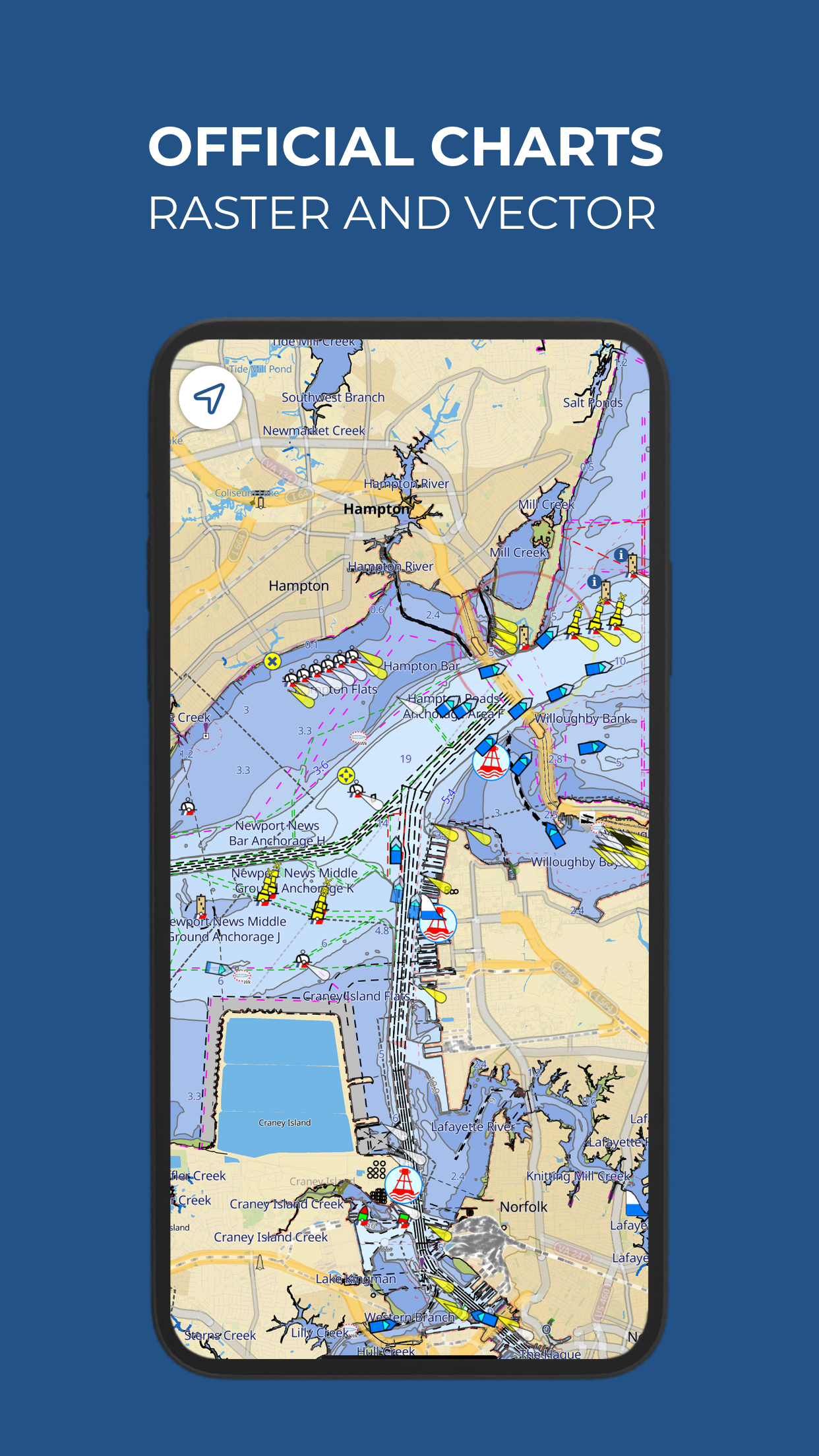
my only complaint with this so far is the maps are not the same as regular charts like navionics. I do like all the information available right on the maps

Don’t Leave Port Without it!

Hot Tub Brian on

Takes a bit of time to learn the basics, but what app doesn’t? Definitely worth the time to learn all its features. Powerful tool. Loaded with features that cost extra, or aren’t available at all, in other navigation apps. Excellent tech support. Worth every penny! Not to mention that you get a lot more for that penny. I was a committed iNavX user until I discovered AquaMap. Now my number 1 electronic navigation software.

Aqua Map

Wingjamr on

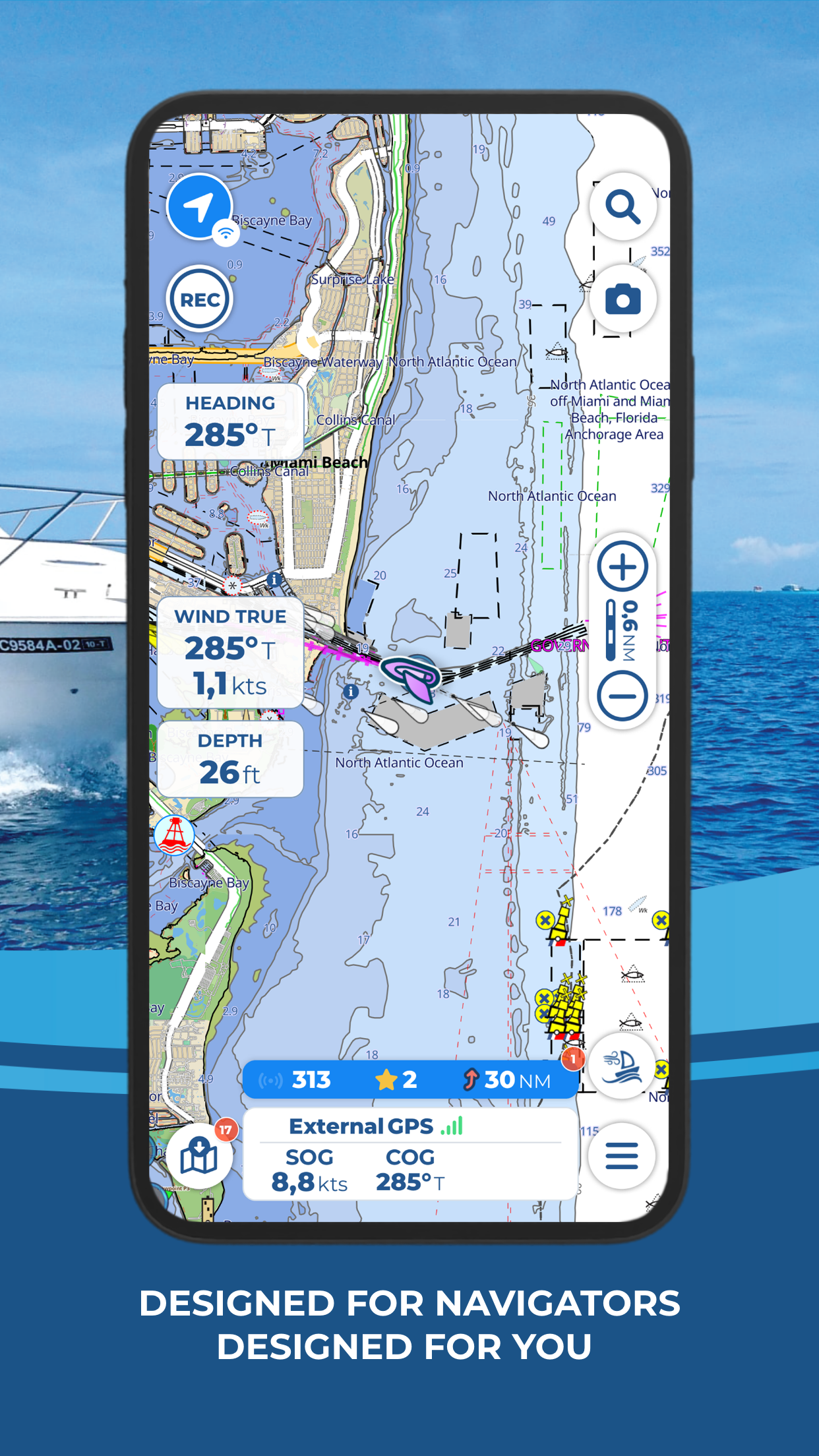
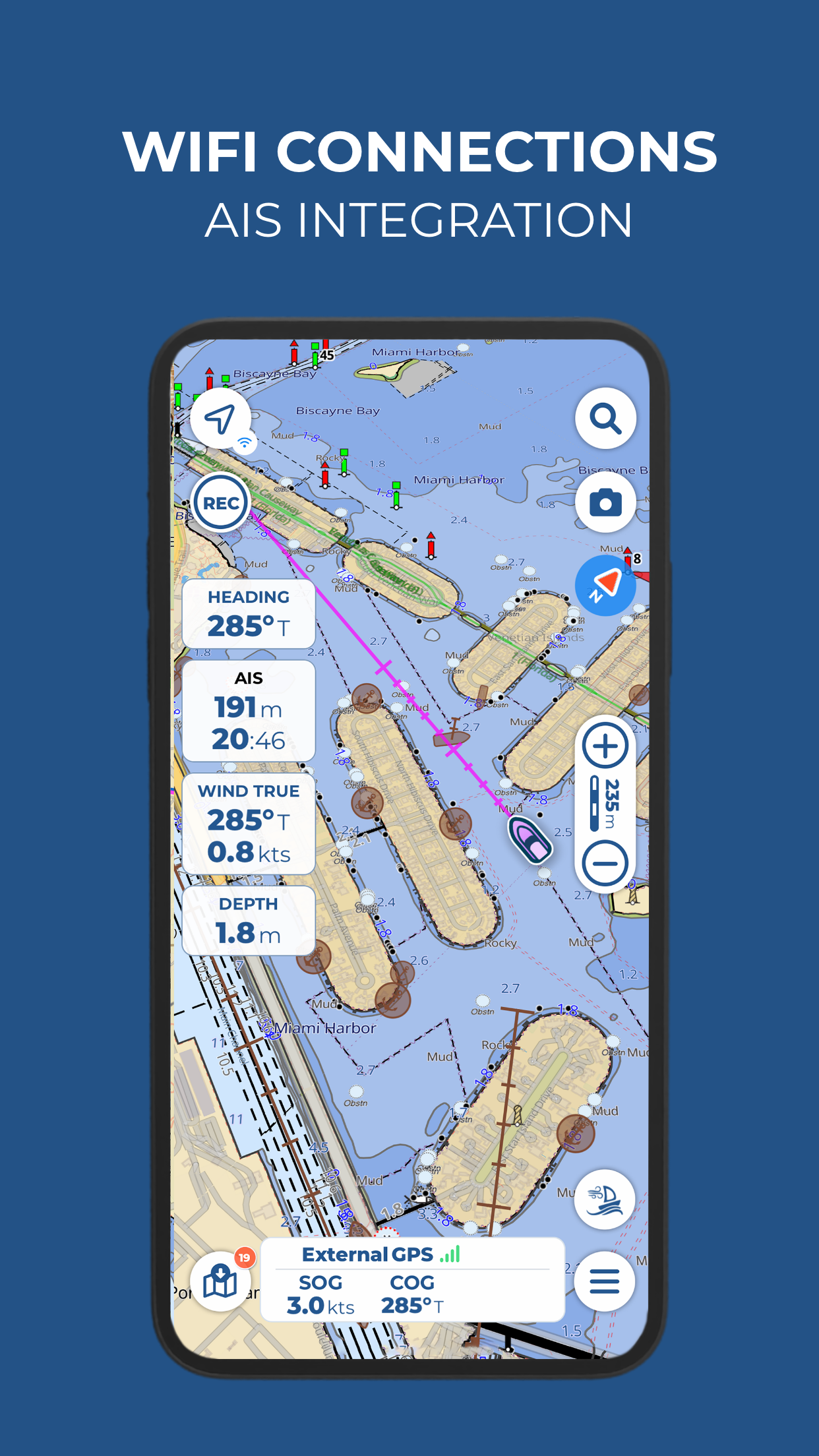
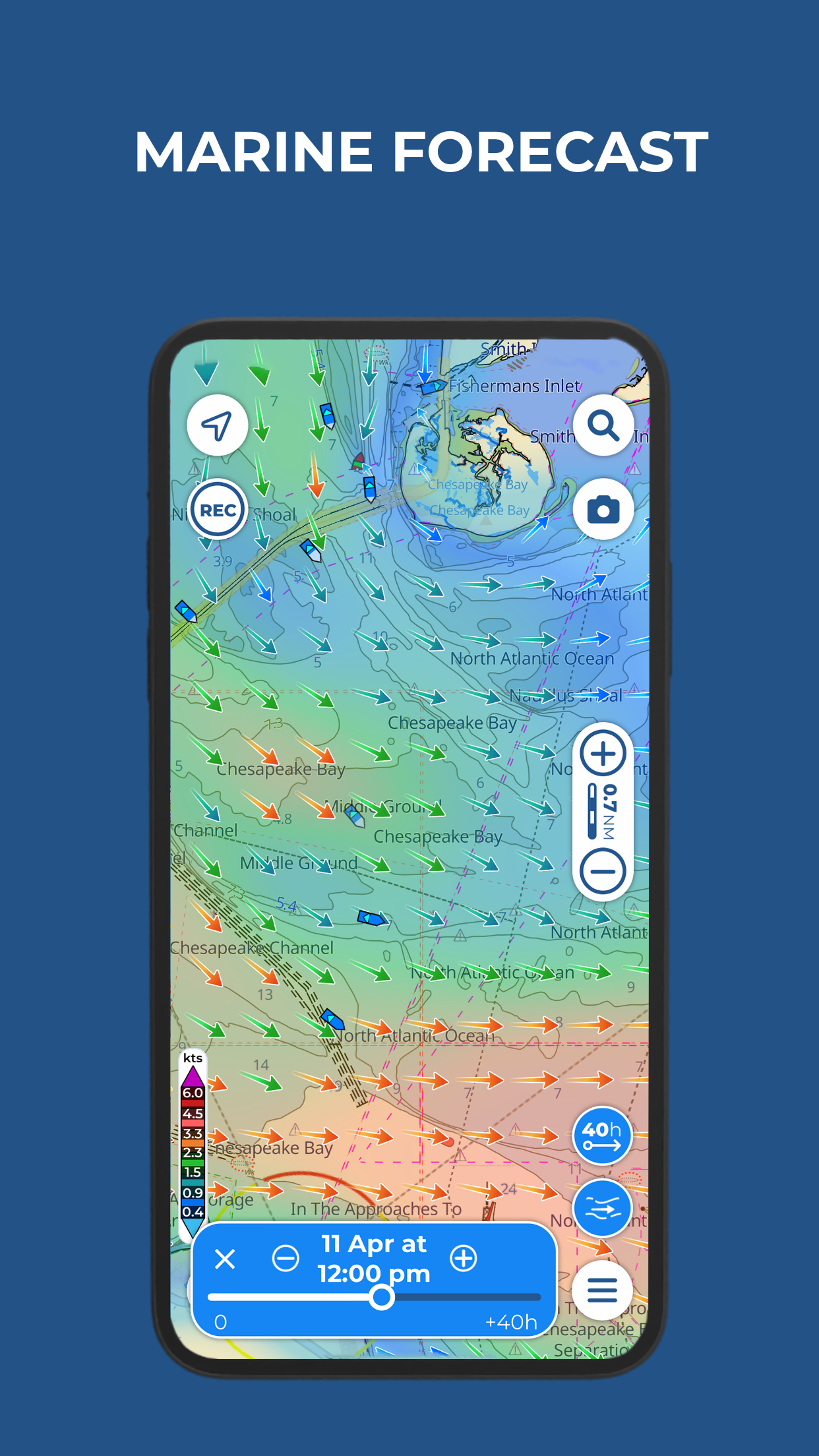
Map display is uncluttered and easy to read. USACE surveys very helpful in navigating the shoals on ICW.

Excellente application pour la pêche…

Doune462 on

Excellente application permettant de télécharger les cartes nautiques et les utiliser offline. Plus facile à utiliser rapidement pour la navigation qu’un GPS de bateau.

Excellent

Thor ⛵️ on

Great full function marine chart plotting software. Easy to use. Well designed and functionality is easy to access. If there’s one thing I love to see is VMG to a waypoint calculated and displayed. I have used the app for 2 full seasons now

Great

Amazing 3738373 on

Great App very detailed.

Rubbish

UsamRid on

Completely un usable in Canada Montreal ottawa Kingston toronto to Lake Superior. Only using charts out of date and free from GoC other services offer these free don’t waste your time!!! Response from manufacturers does not resolve the fact that it is rubbish… blaming that on bad Fed data, decades old does not make this an acceptable tool. While I believe YOU had to pay, WE do not as they are freely available because they are so Old..this could easily resolved if like google you uploaded and pooled data from users… product remains Rubbish for Canada.

So far so good

JoaquindaPark on

Wondering why my downloaded map of the BVIs has 2 different looks.

This app is awesome

Franky the boater on

I love this app. Boating in new areas is a breeze with this app. The stress of boating in the dark is greatly reduced when using this app. Total thumbs up.

GPS inaccurate

enyioma on

The GPS could not even place me in the correct lake. It was so far off I had to look up the name of the lake where it placed me - 62 miles away. It was an absolute waste of $18.99 subscription price.

Store Rankings

Ranking History

Category Rankings

Chart
Category
Rank
Top Grossing
19
Top Grossing
22
Top Grossing
31
Top Grossing
43
Top Grossing
47

Keywords

Users may also like

Name
iNavX: Marine Navigation
Sailing & Boating Chartplotter
Navionics® Boating
Nautical and fishing charts
C-MAP: Boating
Charts, Planning & Navigation
i-Boating: Marine Charts & Gps
Lake Maps & Fishing Spots
Argo - Boating Navigation
Charts, Routes, Tracks, Log
savvy navvy: Boat Navigation
GPS Charts Tide Weather AIS
Waterway Guide
Trusted Boating Resource
PRO CHARTS - Marine Navigation
Wavve Boating: Sail & Boat GPS
Marine Traffic Map Navigation
Dockwa
Dock and mooring reservations
Show More

Revenue and Downloads

Gain valuable insights into Aqua Map Boating performance with our analytics. Sign up now to access downloads, revenue, and more.

App Info

Category
Navigation
Publisher
GEC s.r.l.
Languages
French, German, English, Spanish, Italian, Dutch, Portuguese
Recent version
40.8 (2 weeks ago )
Released on
Oct 15, 2014 (9 years ago )
Last updated
3 days ago