App doesn't work
On my iphone with up to date software the app opens and then closes immediately. It needs to be fixed


3.55 out of 5
31 ratings in United States
On my iphone with up to date software the app opens and then closes immediately. It needs to be fixed
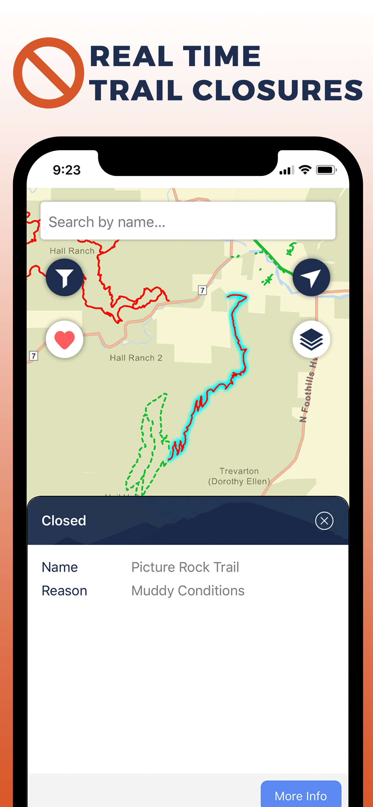
Painfully slow loading (even over fast WiFi). Inaccurate data: Closed trails show as open. UI uses too small text and hard to read colors throughout. Overall a poorly designed and not maintained app.
I downloaded the app and check it every time I go biking to make sure the trails are open. The problem is that it is never accurate. They never update trail status on the app. I don’t know what else to do to know when Boulder decides to open or close their trails. I have been three times to the Marshall Mesa area where the trails are supposed to be open (green) and when I get there, they are closed. This app is just taking space on my phone.
this app has been working awesome!!! thanks and nice job!
This app has one job - to show which trails are open and closed in the area. Unfortunately, it does not reliably do that. Right now in the City of Boulder all Marshall Mesa area trails are closed due to mud, but the app shows them as open. This was also the case yesterday when I showed up to the Marshall Mesa trailhead with friends and found the gate closed. Also, in Boulder County the app is showing Hall Ranch open, when those trials are also closed due to mud. I was originally really excited about this app and recommend it to many people, but I will stop doing that until the app proves to be more accurate. Until then I’ll just continue to reference the agency websites directly.
I’m sure this app will be changing a lot as it gets off the ground. It would be great if it had cross-country skiing as a filter, as well as ease of use, both for skiing or other uses. Also would be great if you could search for off-leash vs on-leash accessibility for dogs.
I live here in Boulder and love open spaces. I’m out with my dog just about every day. Unfortunately, this app is severely lacking. An example - clicking a trail brings up a huge (50% of screen) overlay that covers up the actual trail. Some trails are broken into segments and require tapping through one segment at a time. Any trails is far from a great app but it is also far superior to this one. Maybe next time the dev team will consider doing live user tests to get feedback and make the app better.
App seems slick but borderline unusable missing so many trails. For example Skunk Canyon isn’t listed at all, Mesa Trail has scattered patches, and the Bear/NCAR road which Xcel sporadically closes isn’t listed. Noticed all that in 2 min of looking around so I imagine a lot more is missing. Hopefully they make it actually “comprehensive” like the press around the app launch claims.
Looks good on a phone, but not on an iPad. Will this be improved?
Awesome app! Runs really smooth. Has all the information I need and is up to date.
| Name | Reviews | Recent release | |
|---|---|---|---|

Canopy Parking
|
0
|
5 years ago | |

RTD MyRide
Scan and ride. Welcome aboard!
|
126
|
3 months ago | |

Colorado Trail Explorer
Colorado's Official Trail Map
|
30
|
2 months ago | |

14ers.com
|
105
|
1 month ago | |

ParkDIA
|
100
|
2 years ago | |

Colorado Traveler
|
62
|
1 year ago | |
CDOT Colorado Road Conditions
511 Travel Info & Traffic Cams
|
39
|
1 month ago | |

Campin - Colorado Camping
Dispersed Camping in Colorado
|
13
|
3 years ago | |

Denver Transit: RTD Bus TImes
Next Ride, Trip Planner, Alert
|
45
|
3 weeks ago | |

Colorado Pocket Maps
Colorado Outdoor Guide
|
2
|
3 weeks ago |