Cartograph 2 Lite Map Viewer
View Mapsforge offline maps
#1 Keyword Rankings
Today
Top 10 Rankings
Today
Top 30 Rankings
Today
Top 100 Rankings
Today
Description
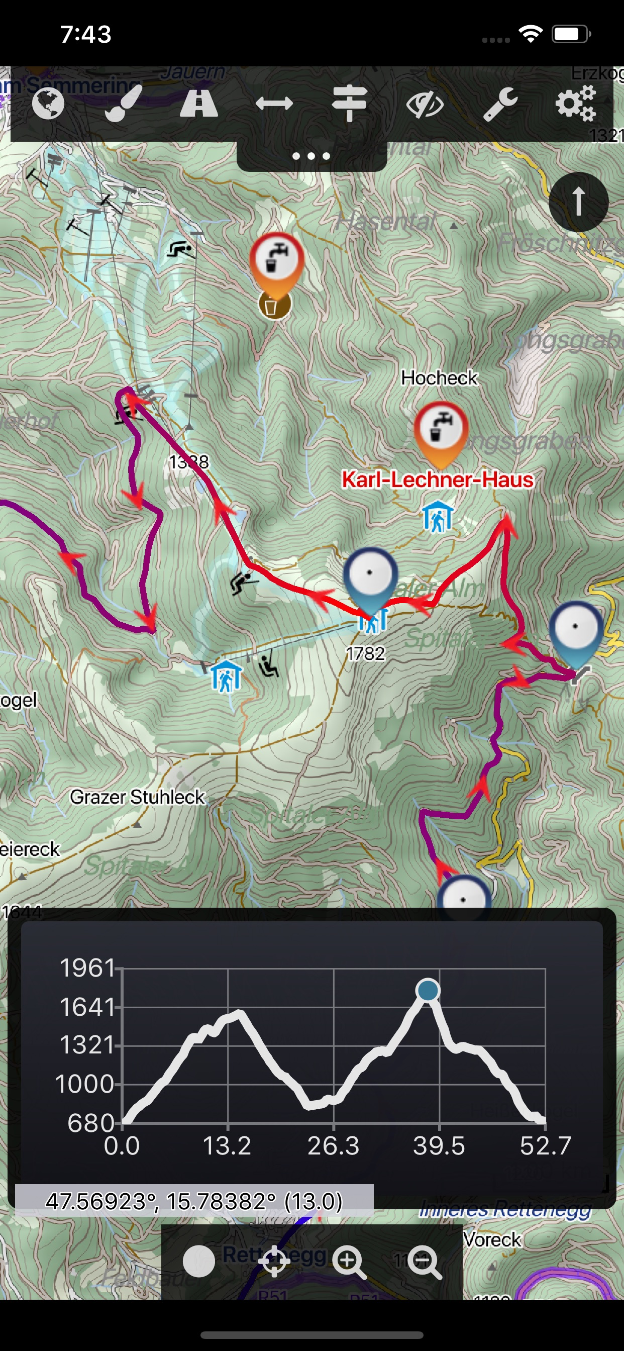
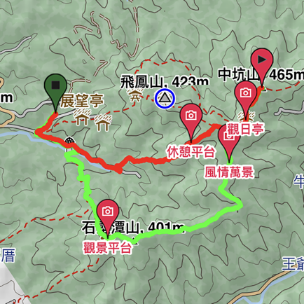
The Cartograph Lite app views Mapsforge offline vector maps, offline raster maps, and online/WMS maps. It supports tracking, route search, overlays, hillshading, reliefs, track drawing, and has many other features.
Pro-version: https://itunes.apple.com/us/app/cartograph-2-maps/id1082995961?ls=1&mt=8
### Lite Version Features ###
- View Mapsforge offline vector maps.
- Offline raster maps: Locus SQLite maps, MBTiles, TwoWays/CompeGPS RMAP*, Oruxmaps SQLite*.
- Online map support (including WMS - Web Map Service maps), e.g. OpenStreetMap, OpenCycleMap, OpenSeaMap, WikiMedia hillshading.
- GPX import and export (basic KML import support).
- Scalable interface (e.g. to increase button sizes).
- Units: Celsius, Kelvin, Fahrenheit, metric, imperial, nautic.
- WaterSupply.at drinking water sources.
- Worldwide, free offline maps.
- Contour lines (Mapsforge maps).
### Additional Pro Features ###
- GPS Track recording.
- Full support for Mapsforge styling/render themes (including hillshading) and layers.
- Custom online map sources.
- Offline hillshading (from HGT/SRTM elevation data).
- Offline relief shading.
- Offline slope map.
- Support for Mapsforge multi-maps (multiple .map files stitched into a single map).
- Night/day mode.
- Manual track drawing and editing.
- Route altitude profile and elevation/slope visualization.
- Online route search.
- Live tracking and polling (using custom server, GPSies.com, or Cartograph server).
- Support for Mapsforge POIs, offline POI search, and dynamic POI loading.
- Compass.
- Decimal and degree coordinate modes.
- Customizable user interface color (dark, light, and colors) and size.
- Strava upload.
* RMAP and Oruxmaps use various map projections and support is experimental. Please contact us if a map does not work so that we can add support for your projection.
Further information: http://www.cartograph.eu
Getting started: https://www.cartograph.eu/gettingstarted
Help&Tutorial: https://www.cartograph.eu/docs
User manual: http://www.cartograph.eu/downloads/usermanual_en.pdf
YouTube how-to videos: https://www.youtube.com/watch?v=dn9EOg5h3yY&list=PLP8X6xYv-qCz46hplsfGLW1LNgywBZrTk
Full version: https://itunes.apple.com/us/app/cartograph-2-maps/id1082995961?ls=1&mt=8
Drop us a line if you have questions, feature requests, or other comments: http://www.cartograph.eu/contact
### Maps ###
- OpenAndroMaps.org: very good maps for outdoor activities.
Hide..
Show more..
Pro-version: https://itunes.apple.com/us/app/cartograph-2-maps/id1082995961?ls=1&mt=8
### Lite Version Features ###
- View Mapsforge offline vector maps.
- Offline raster maps: Locus SQLite maps, MBTiles, TwoWays/CompeGPS RMAP*, Oruxmaps SQLite*.
- Online map support (including WMS - Web Map Service maps), e.g. OpenStreetMap, OpenCycleMap, OpenSeaMap, WikiMedia hillshading.
- GPX import and export (basic KML import support).
- Scalable interface (e.g. to increase button sizes).
- Units: Celsius, Kelvin, Fahrenheit, metric, imperial, nautic.
- WaterSupply.at drinking water sources.
- Worldwide, free offline maps.
- Contour lines (Mapsforge maps).
### Additional Pro Features ###
- GPS Track recording.
- Full support for Mapsforge styling/render themes (including hillshading) and layers.
- Custom online map sources.
- Offline hillshading (from HGT/SRTM elevation data).
- Offline relief shading.
- Offline slope map.
- Support for Mapsforge multi-maps (multiple .map files stitched into a single map).
- Night/day mode.
- Manual track drawing and editing.
- Route altitude profile and elevation/slope visualization.
- Online route search.
- Live tracking and polling (using custom server, GPSies.com, or Cartograph server).
- Support for Mapsforge POIs, offline POI search, and dynamic POI loading.
- Compass.
- Decimal and degree coordinate modes.
- Customizable user interface color (dark, light, and colors) and size.
- Strava upload.
* RMAP and Oruxmaps use various map projections and support is experimental. Please contact us if a map does not work so that we can add support for your projection.
Further information: http://www.cartograph.eu
Getting started: https://www.cartograph.eu/gettingstarted
Help&Tutorial: https://www.cartograph.eu/docs
User manual: http://www.cartograph.eu/downloads/usermanual_en.pdf
YouTube how-to videos: https://www.youtube.com/watch?v=dn9EOg5h3yY&list=PLP8X6xYv-qCz46hplsfGLW1LNgywBZrTk
Full version: https://itunes.apple.com/us/app/cartograph-2-maps/id1082995961?ls=1&mt=8
Drop us a line if you have questions, feature requests, or other comments: http://www.cartograph.eu/contact
### Maps ###
- OpenAndroMaps.org: very good maps for outdoor activities.
Screenshots


 User Rating
0 out of 5
0 ratings in China
Ratings History
Reviews
App doesn't have any reviews yet
Store Rankings
Ranking History
App Ranking History not available yet
Category Rankings
App is not ranked yet
Keywords
Users may also like
| Name | Reviews | Recent release | |
|---|---|---|---|

Guru Offline Maps, GPS Tracker
Off Road Trails Navigation App
|
22
|
2 weeks ago | |

EasyTrails GPS Lite
|
3
|
4 weeks ago | |

TwoNav: Maps Routes
GPS, Orientation and Training
|
0
|
2 weeks ago | |

Topo Maps+
Offline Topographic Maps & GPS
|
2
|
4 weeks ago | |

Terra Map - Trail Explorer
Outdoor trails & topo charts
|
0
|
3 months ago | |
OpenMaps - 地形图 (Dìxíng tú)
Open source topographic maps
|
2
|
2 weeks ago | |

Compass 55. Map & GPS kit.
Land, air, marine navigation
|
1
|
3 weeks ago | |

Vetus Maps
Старинные карты
|
0
|
6 days ago | |
山林日志
完整记录、分享您的户外行程
|
1
|
4 weeks ago | |

3D Maps:Offline map GPS tracks
导航,离线 地图, 指南针,车速表,计步器
|
1
|
2 days ago |
Show More
Revenue and Downloads
Gain valuable insights into Cartograph 2 Lite Map Viewer performance with our analytics. Sign up now
to
access downloads, revenue, and more.
App Info
- Category
- Navigation
- Publisher
- Harald Meyer
- Languages
- English, Chinese, French, Spanish, Dutch, German, Russian, Italian
- Recent version
- 2.6.0 (4 years ago )
- Released on
- Jun 18, 2018 (6 years ago )
- Also available in
- Germany, Taiwan, Italy, Russia, Finland, France, United Kingdom, New Zealand, Pakistan, Norway, Netherlands, Nigeria, Malaysia, Mexico, Lebanon, Kazakhstan, Kuwait, South Korea, Philippines, India, Poland, Portugal, Romania, Saudi Arabia, Sweden, Singapore, Thailand, Turkey, Ukraine, United States, Vietnam, South Africa, Denmark, Argentina, Austria, Australia, Azerbaijan, Belgium, Belarus, Canada, Switzerland, Chile, China, Colombia, Czechia, Japan, Dominican Republic, Algeria, Ecuador, Egypt, Spain, Greece, Hong Kong, Hungary, Indonesia, Ireland, Israel, United Arab Emirates, Peru, Brazil
- Last updated
- 1 month ago