The all new Charts&Tides for iOS7 is finally here! Now get access to charts, tides, ActiveCaptain information, GPS navigation and more in a well designed package. Use it at home to research and plan your trip. Use it on your boat to navigate a route to your final destination.
Charts&Tides was designed with ease of use in mind. The interface is intuitive and tasks have been streamlined. Unlike other marine software, you do not need to download, store and manage individual charts or load them into the software; we have done the legwork for you and compiled large area charts that combine information from multiple sources.
In more detail:
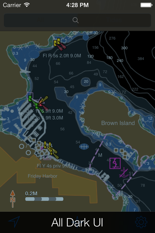
- Provides continuous and seamless large area charts derived from NOAA and CHS vector cartography.
- Shows tide levels and current speeds on the chart using easily interpreted icons. Allows you to judge the water situation around you with a single glance.
- Integrates with the ActiveCaptain interactive cruising guidebook providing you with access to thousands of marinas, anchorages, hazards and other local knowledge.
- Stores the entire ActiveCaptain database offline so that it is always available to you, even without an Internet connection.
- Allows you to instantly search thousands of chart features and the ActiveCaptain database.
- Supports waypoints, routes, tracks and allows you to import and export them in GPX format. Route navigation with automatic waypoint sequencing is also supported.
- Supports multiple options for navigation. You can use your device's built-in GPS or connect to an external GPS via Bluetooth or Wi-Fi. You can also use dead reckoning mode.
- Supports external AIS devices and performs Closest Point of Approach (CPA) computations.
- Comes with a dark UI that looks good during the day and will preserve your night vision when it is dark.
The software comes with a world base map, but does not come prepackaged with any detailed marine charts. You can purchase detailed marine charts from within the application. You can also use the software without purchasing additional charts.
Hide..Show more..
In-Apps
2014 US Marine Vector Chart
$34.99
2015 US Marine Vector Chart
$34.99
2016 US Marine Vector Chart
$34.99
Screenshots
User Rating
1.7 out of 5
10 ratings
in Canada
5 star
1
4 star
1
3 star
0
2 star
0
1 star
8
Ratings History
Reviews
Loss of charts
Upgraded my phone, downloaded the app and no charts came with it. Went to restore previous purchases, nothing! Nice way to rip me off there Navimatics. I guess you expect consumers not to upgrade so they stay on par with your product.....old and inferior.
No maps for my area
I paid the $54, installed the download and there are no maps for the area I am in even though it says they are part of my purchase. Two messages to the developer and no responses in a week!
Good scam
Didn’t update their previous app made people purchase all over again
Charts & Tides
Once my ISO was updated it pretty much rendered this app useless, it appears that I now have to spend another $57 to get it to even function, to say the least I’m not one bit impressed.
No support
Made three separate attempts over two weeks to contact Navimatics for technical support. No response from the app provider. Charts I paid $55 for are now useless. Time to move on, suggest you do the same.
Not impressed
I have been using the navimatics version 4.7 and decided to upgrade to 5.4. The new features are great (route function, etc.) but unlike the old version you have to purchase ($54) the charts for each device! Two emails to the developer and no response...unimpressed.
Just FYI
This app requires you to purchase charts. Without the charts it will show you where your boat is on a body of water and which direction you are going. It will not show you what water you are on or any river names.