SeaNav
Marine Charts and Navigation
#1 Keyword Rankings
Today
Top 10 Rankings
Today
Top 30 Rankings
Today
Top 100 Rankings
Today

Description

Explore, plan and navigate your boating trips in real time and outstanding high-resolution using digital charts derived from the latest NOAA and UKHO data providing coverage across the US and Europe (US, CA, UK & IE, DE, FR, NL, BE, DK, NO,ES,HR,PT). Raster charts for US, NZ, FI & EE.

- Vector charts - all buoys, lights etc. are tappable
- Seamless fast panning and zoom across charts
- Route Planning and real-time tracking
- North up and course up displays
- Offline charts
- Configurable layers
- Built-in tutorial mode with full features including charts, AIS, AR & wind
- Tides, Streams & Weather
- Live AIS Ship positions and collision alarm (IAP)
- Import and share routes and POIs in GPX and KML formats via email and Dropbox
- Live Augmented Reality camera view (IAP) plus FLIRONE® night vision support.
- Includes free Apple Watch app with Nav,Waypoint,Wind,AIS faces.
- NMEA Depth, Wind Speed and Direction
- Real time local wind feed (IAP)

The free version includes all navigation and trip planning tools. High resolution vector charts are available by In App Purchase (IAP) including updates for 12 months.

Vector charts provide many advantages over traditional raster charts. Buoys, Lights, Bridges, Depth Contours, Depth Soundings, Rocks, Anchorage areas, NOAA Weather Buoys etc. are all selectable and have real time distance, bearing and detail information. Turn off layers to de-clutter the display and only show what is important at the time. Tides, moon and sun times and weather are also all available at your fingertips.

In-app tools let you measure distances and bearings and record waypoints on routes to sail. When you are out at sea, the app’s Sailing HUD shows your position on the route, Course over ground (COG), Speed over ground (SOG), Vector Made Good (VMG), Estimated Time of Arrival (ETA), Distance and bearing to next Waypoint. Waypoint reached alerts, auto-routing to the next waypoint and flashing collision alerts (with AIS).

Unique AR view mode (IAP) allows you to view buoys, lights, ships, waypoints, route and track overlaid on your iPhone or iPad live camera view. With "AR LockOn" you can select a target on the chart and then be guided to it in the AR camera view. You can also see at night and in the fog with the FLIRONE Infra-red camera.

External NMEA GPS, AIS and Wind data over Wifi.

Requirements:
GPS only required for real time route navigation. Optional Real time AIS, Tides and Weather information require an active internet connection.

WiFi-only iPad or iPods will need an external GPS receiver for navigation.

Please note that continued use of GPS running in the background can dramatically decrease battery life.

Subscriptions
Our in-app purchases are 1 year subscriptions, which automatically renew at the end of the subscription period unless auto-renew is turned off at least 24-hours before the end of the current period. Payment will be charged to your iTunes Account at confirmation of purchase, and will be charged for renewal within 24-hours prior to the end of the current period. Pricing for our 1 year US Charts update subscription is $19.99.

Subscriptions may be managed by the iTunes account holder and auto-renewal may be turned off by going to Account Settings after purchase. 
No cancellation of the current subscription is allowed during active subscription period.

NOTICES: This product has been derived in part from material obtained from the UK Hydrographic Office with the permission of the UK Hydrographic Office, Her Majesty’s Stationery Office.” “© British Crown Copyright, [2012]. All rights reserved.

The UK Hydrographic Office (UKHO) and its licensors make no warranties or representations, express or implied, with respect to this product. The UKHO and its licensors have not verified the information within this product or quality assured it.

Terms of Use: http://seanav.net/termsofuse.php

Privacy Policy: http://seanav.net/privacy.php

Support: [email protected]
Hide.. Show more..

In-Apps

US Charts
$26.49
Pro Features
$19.99
BE & NL Charts
$28.99
Weather charts
$6.99
Canadian Charts
$34.99
Croatian Charts
$34.99
Norwegian Charts
$24.99
Portuguese Charts
$24.99
NOAA US Raster Charts
$13.99

Screenshots

User Rating

4.27 out of 5

33 ratings in Canada

5 star
23
4 star
4
3 star
1
2 star
2
1 star
3

Ratings History

Reviews

NOAA CHARTS ARE FREE TO THE PUBLIC

larryfrombarrie on

Any app that makes you pay for them is ripping you off…

Super app

steph quebec on

Really like this app and the info on my Apple watch. But above all outstanding support!

Useful app

Jim 5o5 on

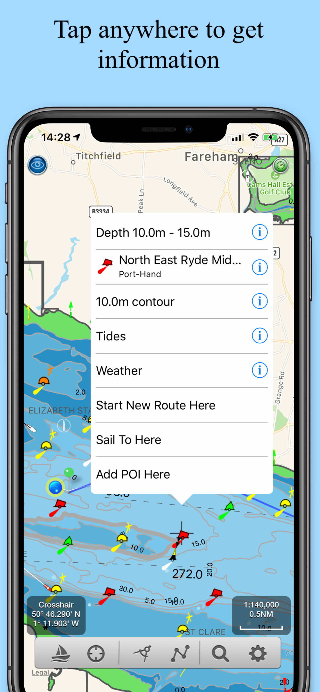
Works great on my iPad. The app has lots of features. Route planning, storage of waypoints, information and reviews of anchorages. You can click anywhere and instantly see the depth at that point. I don't have a cellular connection on my iPad. I bought a portable wifi connected GPS antenna from Bad Elf. The antenna fits in the palm of my hand, and is rechargeable. I then have proper GPS coverage anywhere. I could see where I was 700 miles north of Hawaii. In local waters I connect to my iPhone then I can get live AIS information. I only make this connection when I need it to look at nearby boats. I don't want to eat up wireless minutes.

First use during 4 day Lake Erie cruise

Eriewinds on

Hi, We just got back from 4 days sailing Port Dover -> Port Maitland -> Port Colborne -> Port Maitland -> Port Dover. We had installed SeaNav and Navionics on a pair of iPads connected to our NMEA 2000 system via a Yacht Devices YDWG-02 server port. SeaNav easily won the evaluation and we did not try to use the Navionics after the first day. An outstanding success! David Bramwell Sailing vessel Eriewinds, Port Dover

Great app with accurate Canadien data

Anras001 on

I like this supporting app to plan my selling navigation and play back. To the dev team. Keep going on dev.

Total disappointment

Yunustech on

Charts are not detailed. Maps have very low resolution. Speed reading was way off. Waste of time and money

Store Rankings

Ranking History

Category Rankings

Chart
Category
Rank
Top Free
130
Top Free
287
Top Free
306
Top Free
336
Top Free
361

Keywords

Users may also like

Name
AIS Maps: Marine & Lake charts
Detailed nautical & topo maps
C-MAP: Boating
Charts, Planning & Navigation
PRO CHARTS - Marine Navigation
Aqua Map Boating
Marine navigation and fishing
TZ iBoat – Marine Navigation
Boat GPS, Charts, AIS, Tides
Seapilot
B&G: Companion App for Sailors
Great sailing charts
WinGPS Marine
Marine Navigation Lite
Offline GPS tracker for boat
OnCourse - boating & sailing
Navigation - mAIS
Show More

Revenue and Downloads

Gain valuable insights into SeaNav performance with our analytics. Sign up now to access downloads, revenue, and more.

App Info

Category
Navigation
Languages
Danish, English, French, German, Spanish
Recent version
5.4.9 (3 weeks ago )
Released on
Apr 24, 2014 (10 years ago )
Last updated
1 week ago