Flyskyhy

Published by: Renevision
Downloads
Revenue

Description

Flyskyhy forms your flight instrument during flight and shows all information you need for that. You get the normal data like altitude, climb rate, ground speed, and glide angle. But it also calculates and shows the current wind direction and strength, very important for your safety.
A moving and rotating map shows your current flying position and flight trail. It indicates where you have gone up (in a thermal), and where you have had faster than normal decline. With that, you can easily find back that thermal that you lost. The map also shows the nearest known landing spots, and whether they are reachable by normal glide, given your current altitude and wind direction.
Integration with Bluetooth varios SensBox, FlyNet, GoFly iPico, XC-Tracer, BlueFlyVario, or SkyDrop gives accurate altitude and lift information. That turns your iPhone into an full-fletched GPS-vario, including vario tones.
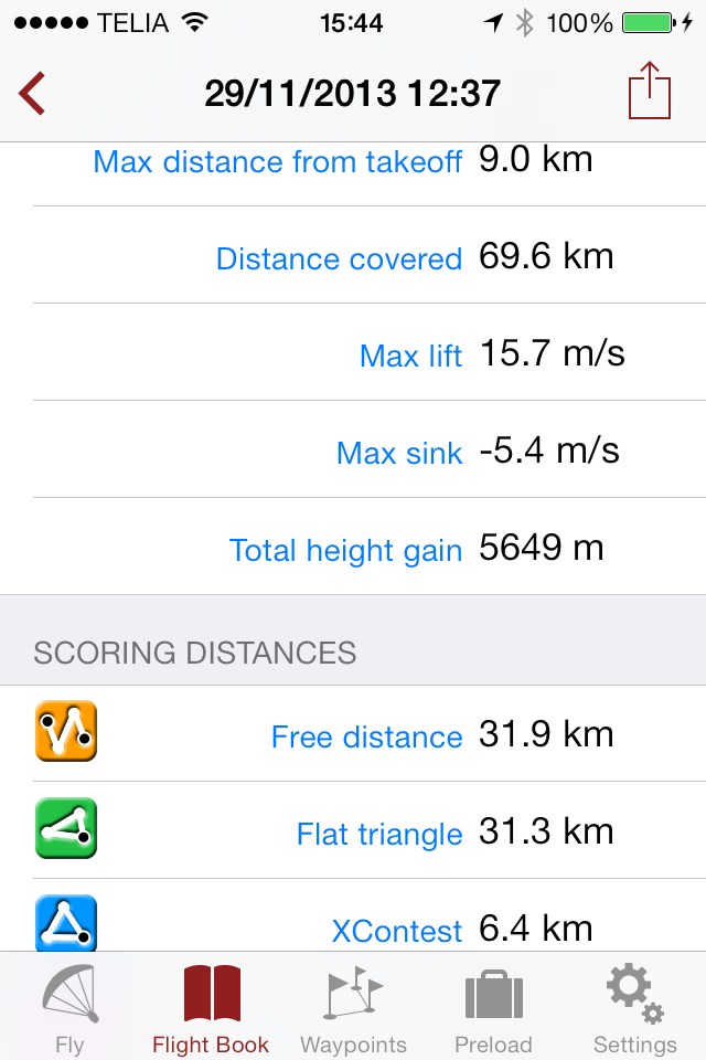
The app makes a full log of your flight, that can be analyzed afterwards. Besides normal data like start and landing positions, duration of flight, and an altitude graph of the flight, Flyskyhy also calculates the scoring distances for you. So you can immediately see whether you have broken that FAI triangle record.
Your live location is reported on livetrack24.com or loctome.com if you desire, so anybody can follow your flight while it is happening. If you are flying together with friends, then their location is shown on your map during your flight. So you never have to wonder anymore whether they are in front of or behind you.
The flight display has multiple screens which are all fully configurable. You can move all elements to other spots, delete and add elements, and resize them.
Through in-app purchases, the app also supports airspaces and waypoints.
The app is optimised for paragliding and hang gliders, but can be used with all kinds of airsports.
Main features during the flight;
• Altitude, climb rate, ground speed, air speed, direction, glide angle and many more
• Wind strength and direction
• Moving map of the flying area
• Spots where you have had lift, great for thermal coring
• Shows whether you can still reach a landing spot with the current altitude and wind
• Live tracking of your flight on livetrack24.com or loctome.com
• Shows live location of your friends during flight
After the flight:
• Full logbook of all your flights
• Basic flight data like start/landing, duration, height difference, distance flown, and many more
• Calculation of 5-points, open triangle, and FAI triangle distances
• Graph of altitude and climb rate
• Signed IGC and KML log files of flights
• Transfer the log to iTunes or send by email
• Upload the flight directly to XContest, ParaglidingForum, DHV-XC, and other Leonardo servers
• Open flight in Google Earth on the iPhone
• Replay the flight and relive it!
By purchasing the Waypoints Extension you get access to:
• A fully zoomable and scrollable map with the waypoints and optimised route. The map also shows start and landing spots, as well as restricted airspaces (with the Airspace Extension)
• Enter new waypoints, either on the map or by specifying the parameters
• Full route support with start time, goal, entry/exit points, etc.
• Many instruments to guide you along the route
• Visible and audible indication when a waypoint has been reached
• Complete waypoints organiser
• Import and export of various waypoint file formats
By purchasing the Airspace Extension you get access to:
• Airspaces of 30 countries
• Display of airspaces on the map with configurable colors and formats
• Display of your vertical position w.r.t. airspaces
• Visible and audible warnings when approaching and entering an airspace
• Shows local airspaces by touching a spot on the map
Note: a live internet connection is required for live tracking of your and your friends locations
Note: continuous GPS and screen usage makes the battery drain faster than normal
Hide Show More...

In-Apps

Social
£3.99
Airspaces
£7.99
Waypoints
£7.99
XC-Package
£7.99
Map Download
£6.49

Screenshots

Flyskyhy FAQ

  • Is Flyskyhy free?

    No, Flyskyhy is not free (it costs 8.99), and it also contains in-app purchases.

  • Is Flyskyhy legit?

    🤔 The Flyskyhy app's quality is mixed. Some users are satisfied, while others report issues. Consider reading individual reviews for more context.

    Thanks for the vote

  • How much does Flyskyhy cost?

    Flyskyhy costs 8.99 to download (and they also have additional in-app purchases).

  • What is Flyskyhy revenue?

    To get estimated revenue of Flyskyhy app and other AppStore insights you can sign up to AppTail Mobile Analytics Platform.

User Rating

4.54 out of 5

35 ratings in United Kingdom

5 star
29
4 star
2
3 star
1
2 star
0
1 star
3
Ratings History

Flyskyhy Reviews

Brilliant app

BfG16 on

United Kingdom

This app is so good. If you’re an iPhone user and paraglider pilot then it’s the obvious choice. The guys who complain about costs can’t be serious pilots it is such good value for so many features and the developer keeps it current and adds new features. Superb!

Brilliant paragliding gap vario.

Islandbagger on

United Kingdom

Works best when paired with a power pack (to keep iPhone charged) and one of these makes of Bluetooth vario: Digifly Bluefly XCTracer Totally customisable displays. Great for XC and airspace avoidance.

Money pit

Cloudeater on

United Kingdom

Paid for the app and then was asked to pay for essential add on’s. Waypoint £7.99. Maps 7.99. Etc. buyer beware!

Beware the hidden costs!

fitabar on

United Kingdom

Beware, the initial purchase just gets a basic, stripped down app. To get full functionality - things like airspace, waypoints, thermal assist, map pre-download etc means spending three or four times that of the price paid for. The app looks great, but the reliance upon in-app purchases feels like a bit of a con. There’s £8 I won’t see again! :(

Great App

Tortoisebob on

United Kingdom

Fantastic app at a great price. Starting out in paragliding this is a great way to track and review flights. Any chance of adding a running total time of the logged flights? This would make it easier to track airtime and hours on the wing.

Good option for PG or PPG

Wrant on

United Kingdom

I have now done 5 PPG flights with this APP and have 4 customised pages to suit my needs. For PPG in the UK the airspace option is very useful. I have recommended it to folk at my club. I would advise that you attach your phone to a power bank as you fly as it uses a lot of my battery. It is also possible to view your flight records in 3D google earth

Happy with this

OdeTheBear on

United Kingdom

I fly paramotor (PPG) and this fits my needs best out of the few apps I have tried. Nothing wrong with E.G. XCSoar, Paraglider Dashboard or Variometer this is really a personal choice depends what you want. This app is so easy to personalize ie set your own screen layout. There are nine after flight log file output formats choices, they should cover most users needs. The “show hand go to next screen” works well. Mostly I was impressed with the support though. I asked a question from the developer and got a reply in less than 24h (October 2018).

Could not connect to web live tracker

ShaunoZA on

United Kingdom

Complete rip off.... does not work with live track 24 as advertised Please refund me

Great app

Mike7111 on

United Kingdom

Brilliant app and getting better all the time. Don't waste your money on oudies etc if you have an iPhone. Get this and an external battery and you're sorted.

Just superb

Egineerpilot65436 on

United Kingdom

I use this for hang gliding. Paired with a Flynet 2 Bluetooth vario and with an iPhone 4s mounted on my arm. I also use an external battery and wired earphones inside my helmet. About 14 hours battery life. Intuitively customisable and very clear display, so full of features that it defies description. Would like a separate volume control for the sink tone but that is my solitary, non-significant gripe. Try it!

Store Rankings

Ranking History
Category Rankings
Chart
Category
Rank
Top Paid
1
Top Paid
2
Top Paid
2
Top Paid
3
Top Paid
3

Keywords

Flyskyhy Competitors

Name
SportsTrackLive: Action Sports
Real-time Tracking & 3D Replay
XCMania
Never lose thermal, fly in 3D.
Syride
Connect your Sys'Nav XL!
Paragliding Map
Most popular free-flight app!
Paragliding Tracker: Wingman
Record, Log flight, Variometer
Rogallo BlackBox
Paragliding Flight Logbook
Variometer+
Vertical Speed,Responsive,Fly
burnair Map
Gaggle - Flight Recorder
A paragliding flight recorder
Volandoo Tracker
Tracker

Flyskyhy Installs

Last 30 days

Flyskyhy Revenue

Last 30 days

Flyskyhy Revenue and Downloads

Gain valuable insights into Flyskyhy performance with our analytics.
Sign up now to access downloads, revenue, and more.

App Info

Category
Sports
Publisher
Renevision
Languages
Dutch, English, French, German, Italian, Portuguese, Spanish, Swedish
Recent release
8.2.5 (2 months ago )
Released on
Apr 17, 2012 (12 years ago )
Last Updated
4 days ago
This page includes copyrighted content from third parties, shared solely for commentary and research in accordance with fair use under applicable copyright laws. All trademarks, including product, service, and company names or logos, remain the property of their respective owners. Their use here falls under nominative fair use as outlined by trademark laws and does not suggest any affiliation with or endorsement by the trademark holders.