
i-Boating: USA Marine Charts
Nautical + Lake Contour Maps
#1 Keyword Rankings
Today
Top 10 Rankings
Today
Top 30 Rankings
Today
Top 100 Rankings
Today
Description
This App offers access to NOAA marine vector charts, freshwater lake maps, USACE inland river maps (HD/1ft/3ft bathymetry included where available). First marine GPS app to have route assistance with Voice Prompts for marine navigation. You can create new boating routes or import existing GPX/KML routes. It supports Nautical Charts course up orientation. Includes Tide & Currents prediction.
►FEATURES
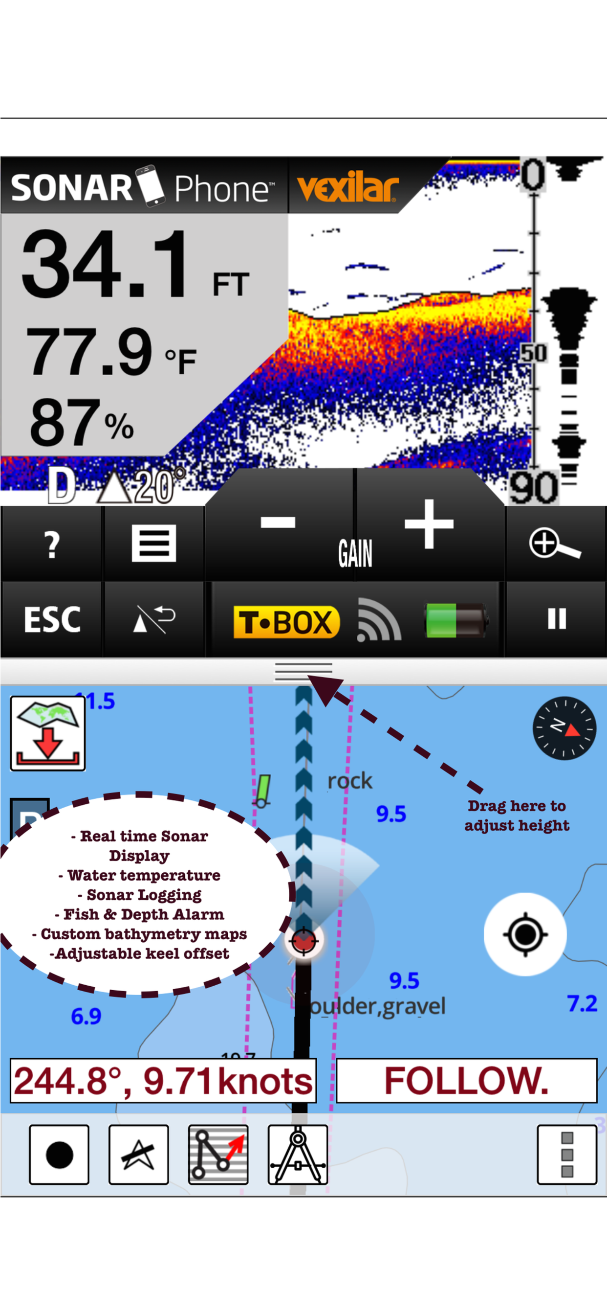
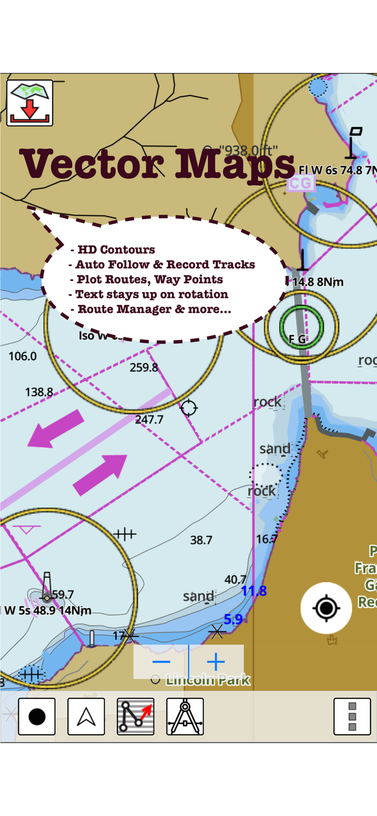
√ Beautiful and detailed Hardware/GPU accelerated vector charts (text stays upright on rotation)
√ Long press to query the details of Marine object (Buoy, Lights, Obstruction etc).
√ Customizable depth(Ft/Fathom/Meter) and distance units (km/mi/NM)
√ Customizable Shallow Depth.
√ Record tracks, Autofollow with real-time track overlay & predicted path vector.
√ Voice Prompts for marine navigation (requires GPS )
√ 1ft / 3ft depth contour maps for anglers for selected lake maps.
√ Supports GPX/KML for boating route editing/import.
√ Tide & Currents prediction.
√ Seamless chart quilting of marine charts
√ Enter or import Waypoints.
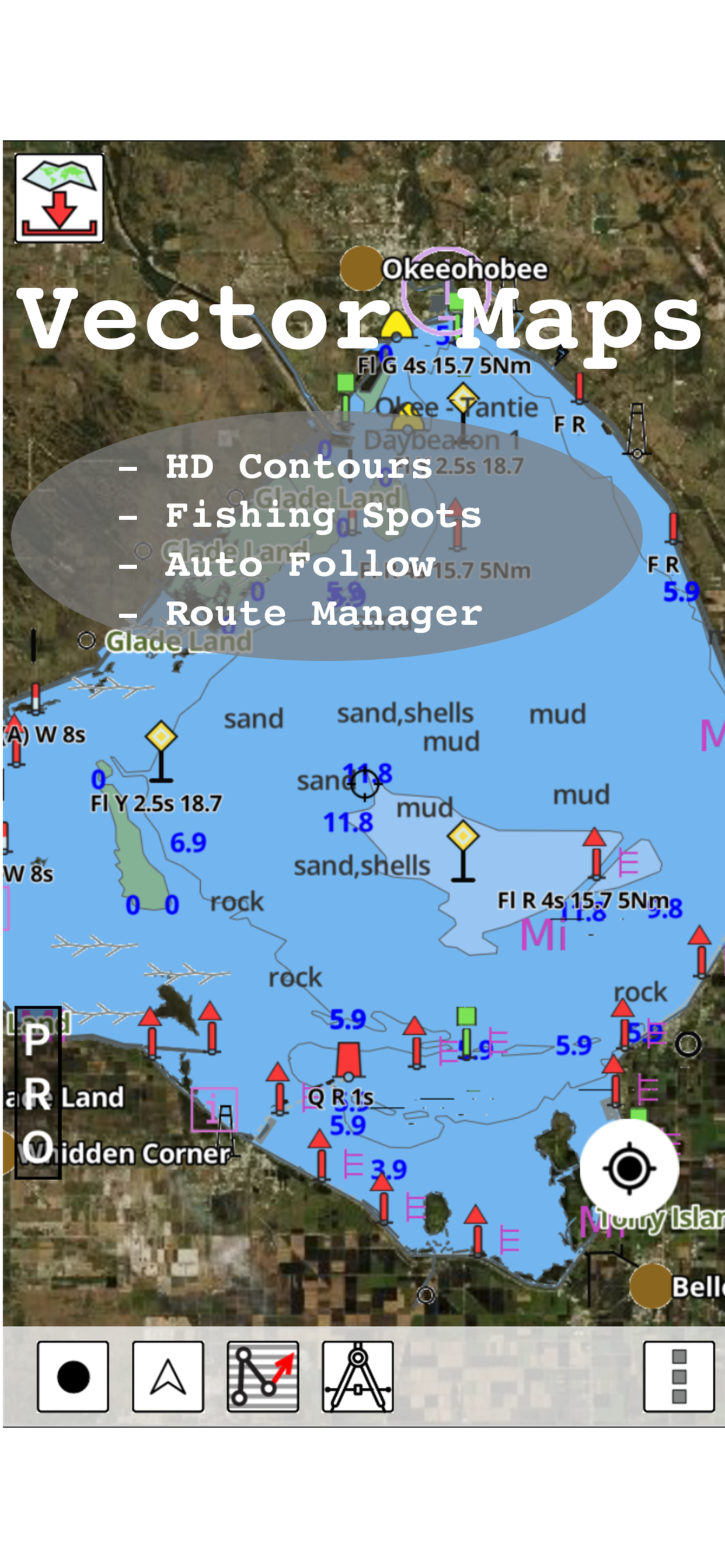
► MAPS
The maps include coverage of all NOAA marine vector charts (ENC), USACE inland river maps, and freshwater lake maps for more than 7K lakes. The charts include HD/1ft/3ft bathymetry where available. The app also includes NOAA raster charts for some areas where NOAA ENC coverage is not available. It includes unlimited updates for 1 year.
►ROUTE MANAGEMENT / TRIP PLANNING
√ Create New Route/Edit Existing Routes
√ Move Points
√ Add points to an existing route leg
√ Delete / Rename points
√ Import GPX, KML & KMZ files
√ Plot/Edit Routes
√ Enter Waypoints
√ Share/Export Routes, Tracks & Markers
√ Reverse Routes
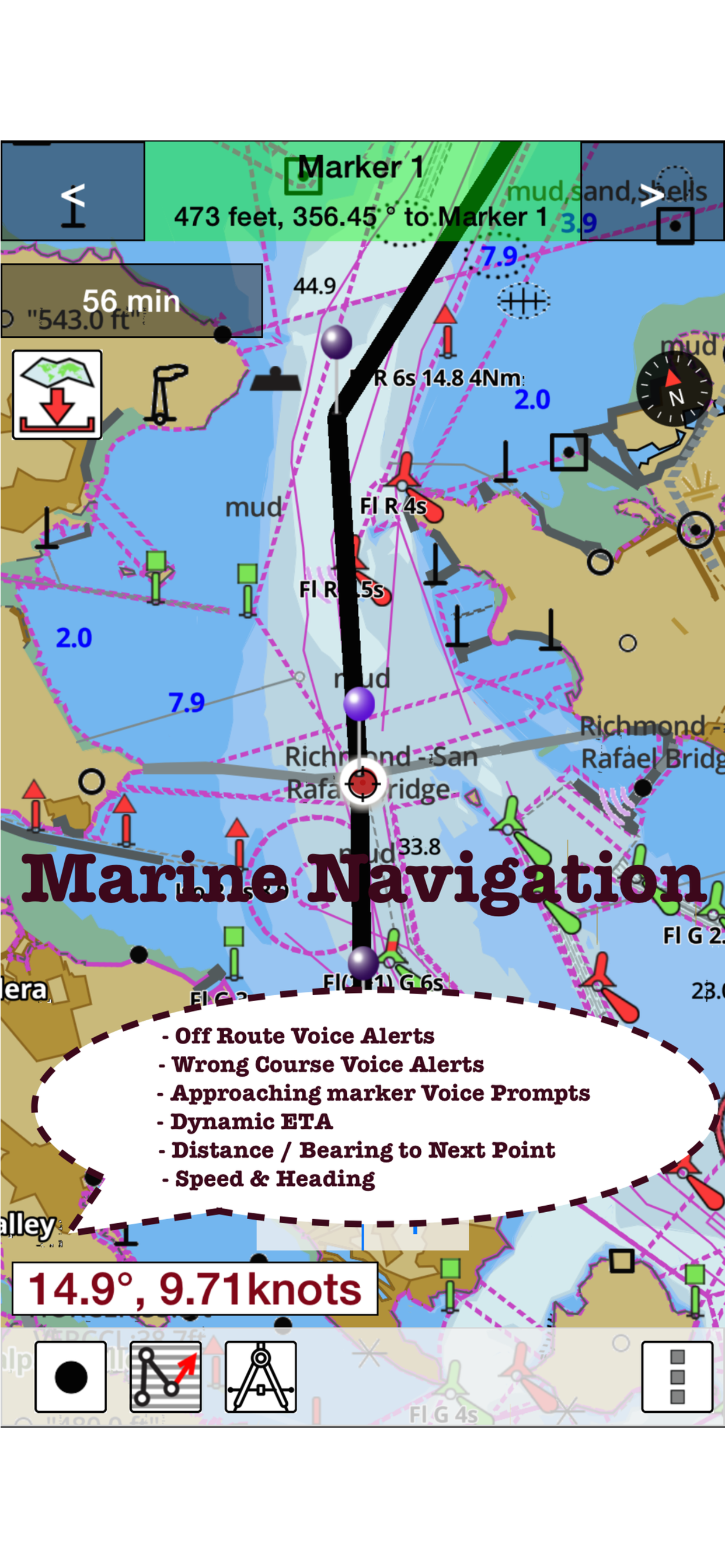
►GPS FEATURES
√ Auto Follow
* Real Time Track Overlay
* Predicted Path Vector
* Course Up (Text stays upright)
* Speed & Heading
√ Route Assistance With Voice Prompts
* Prompts when approaching a boating route marker
* Continous distance and ETA updates
* Alerts when sailing/boating off route
* Alerts when boating in wrong direction
√ Record Tracks
►TIDE & CURRENTS
* For US, Canada, UK, Germany & New Zealand
* High/Low Tides
* Tidal Current Prediction
* Active Current Stations
► SHARING
* Share tracks/routes/markers on Facebook & Twitter
* Export tracks/routes/markers as compressed GPX files.
Sample Nautical Charts (please visit http://gpsnauticalcharts.com/main/folio-catalog-nautical-charts-app for complete list)
SUGARLOAF KEY-KEY WEST
PORT RICHEY TAMPA BAY - CLEARWATER HBR
EAST BAY-WEST BAY FLORIDA
ST JOSEPH, ST ANDREW BAYS
INTRACOASTAL WATERWAY MATECUMBE-GRASSY KEY
CHESAPEAKE BAY CAPE CHARLES-NORFOLK HARBOR
ANCLOTE KEYS-CRYSTAL RIVER
ST JOSEPH SOUND
MIAMI HARBOR
Minnesota lakes - Kabetogama, Minnetonka, Waconia,Leech,Mille Lacs
Lake Keowee,Jocassee,Hartwell,Greenwood,Lake Murray
Mark Twain,Ozarks,Table Rock
Lake St. Clair
Lake Kentucky
KEY WEST-THE MISSISSIPPI RIVER
SAN PEDRO CHANNEL
LAKE MICHIGAN STONY LAKE-POINT BETSIE
APALACHICOLA BAY-CAPE SAN BLAS
EAST CAPE-MORMON KEY
CAPE HENLOPEN-INDIAN RIVER INLET
CHESAPEAKE BAY CAPE HENRY-THIMBLE SHOAL LIGHT
DULUTH-SUPERIOR HARBOR
MONHEGAN ISLAND-CAPE ELIZABETH
LAKE ONTARIO - CLAYTON-FALSE DUCKS ISL
Lake Winnipesaukee
SAN FRANCISCO ENTRANCE
MIAMI-MARATHON, FLORIDA BAY
CAPE MAY-FENWICK ISLAND
MISSISSIPPI RIVER-GALVESTON
CAPE CANAVERAL-KEY WEST
DELAWARE RIVER WILMINGTON-PHILADELPHIA
FLORIDA KEYS SOMBRERO KEY-SAND KEY
SAN PABLO BAY
RAINY LAKE BIG ISLAND MINN-OAKPOINT ISL ONT
INTRACOASTAL WATERWAY - BISCAYNE BAY
EVERGLADES NTL PARK - SHARK RVR-LOSTMANS RVR
MIAMI-MARATHON & FLORIDA BAY
BLACKBURN BAY
LAKE HURON
LAKE TAHOE
STRAITS OF MACKINAC
NORFOLK HARBOR & ELIZABETH RIVER
SAN DIEGO-SANTA ROSA ISLAND
DELAWARE BAY
CHOPTANK RIVER CAMBRIDGE-GREENSBORO
FORT LAUDERDALE PORT EVERGLADES
ST SIMONS SOUND-TOLOMATO RIVER
CHESAPEAKE DELAWARE CANAL
PLEASE NOTE: Continued use of GPS running in the background can dramatically decrease battery life.
Hide..
Show more..
►FEATURES
√ Beautiful and detailed Hardware/GPU accelerated vector charts (text stays upright on rotation)
√ Long press to query the details of Marine object (Buoy, Lights, Obstruction etc).
√ Customizable depth(Ft/Fathom/Meter) and distance units (km/mi/NM)
√ Customizable Shallow Depth.
√ Record tracks, Autofollow with real-time track overlay & predicted path vector.
√ Voice Prompts for marine navigation (requires GPS )
√ 1ft / 3ft depth contour maps for anglers for selected lake maps.
√ Supports GPX/KML for boating route editing/import.
√ Tide & Currents prediction.
√ Seamless chart quilting of marine charts
√ Enter or import Waypoints.
► MAPS
The maps include coverage of all NOAA marine vector charts (ENC), USACE inland river maps, and freshwater lake maps for more than 7K lakes. The charts include HD/1ft/3ft bathymetry where available. The app also includes NOAA raster charts for some areas where NOAA ENC coverage is not available. It includes unlimited updates for 1 year.
►ROUTE MANAGEMENT / TRIP PLANNING
√ Create New Route/Edit Existing Routes
√ Move Points
√ Add points to an existing route leg
√ Delete / Rename points
√ Import GPX, KML & KMZ files
√ Plot/Edit Routes
√ Enter Waypoints
√ Share/Export Routes, Tracks & Markers
√ Reverse Routes
►GPS FEATURES
√ Auto Follow
* Real Time Track Overlay
* Predicted Path Vector
* Course Up (Text stays upright)
* Speed & Heading
√ Route Assistance With Voice Prompts
* Prompts when approaching a boating route marker
* Continous distance and ETA updates
* Alerts when sailing/boating off route
* Alerts when boating in wrong direction
√ Record Tracks
►TIDE & CURRENTS
* For US, Canada, UK, Germany & New Zealand
* High/Low Tides
* Tidal Current Prediction
* Active Current Stations
► SHARING
* Share tracks/routes/markers on Facebook & Twitter
* Export tracks/routes/markers as compressed GPX files.
Sample Nautical Charts (please visit http://gpsnauticalcharts.com/main/folio-catalog-nautical-charts-app for complete list)
SUGARLOAF KEY-KEY WEST
PORT RICHEY TAMPA BAY - CLEARWATER HBR
EAST BAY-WEST BAY FLORIDA
ST JOSEPH, ST ANDREW BAYS
INTRACOASTAL WATERWAY MATECUMBE-GRASSY KEY
CHESAPEAKE BAY CAPE CHARLES-NORFOLK HARBOR
ANCLOTE KEYS-CRYSTAL RIVER
ST JOSEPH SOUND
MIAMI HARBOR
Minnesota lakes - Kabetogama, Minnetonka, Waconia,Leech,Mille Lacs
Lake Keowee,Jocassee,Hartwell,Greenwood,Lake Murray
Mark Twain,Ozarks,Table Rock
Lake St. Clair
Lake Kentucky
KEY WEST-THE MISSISSIPPI RIVER
SAN PEDRO CHANNEL
LAKE MICHIGAN STONY LAKE-POINT BETSIE
APALACHICOLA BAY-CAPE SAN BLAS
EAST CAPE-MORMON KEY
CAPE HENLOPEN-INDIAN RIVER INLET
CHESAPEAKE BAY CAPE HENRY-THIMBLE SHOAL LIGHT
DULUTH-SUPERIOR HARBOR
MONHEGAN ISLAND-CAPE ELIZABETH
LAKE ONTARIO - CLAYTON-FALSE DUCKS ISL
Lake Winnipesaukee
SAN FRANCISCO ENTRANCE
MIAMI-MARATHON, FLORIDA BAY
CAPE MAY-FENWICK ISLAND
MISSISSIPPI RIVER-GALVESTON
CAPE CANAVERAL-KEY WEST
DELAWARE RIVER WILMINGTON-PHILADELPHIA
FLORIDA KEYS SOMBRERO KEY-SAND KEY
SAN PABLO BAY
RAINY LAKE BIG ISLAND MINN-OAKPOINT ISL ONT
INTRACOASTAL WATERWAY - BISCAYNE BAY
EVERGLADES NTL PARK - SHARK RVR-LOSTMANS RVR
MIAMI-MARATHON & FLORIDA BAY
BLACKBURN BAY
LAKE HURON
LAKE TAHOE
STRAITS OF MACKINAC
NORFOLK HARBOR & ELIZABETH RIVER
SAN DIEGO-SANTA ROSA ISLAND
DELAWARE BAY
CHOPTANK RIVER CAMBRIDGE-GREENSBORO
FORT LAUDERDALE PORT EVERGLADES
ST SIMONS SOUND-TOLOMATO RIVER
CHESAPEAKE DELAWARE CANAL
PLEASE NOTE: Continued use of GPS running in the background can dramatically decrease battery life.
Screenshots


 User Rating
0 out of 5
0 ratings in Peru
Ratings History
Reviews
App doesn't have any reviews yet
Store Rankings
Ranking History
App Ranking History not available yet
Category Rankings
|
Chart
|
Category
|
Rank
|
|---|---|---|
|
Top Paid
|

|
124
|
|
Top Paid
|

|
431
|
|
Top Paid
|

|
500
|
Keywords
Users may also like
| Name | Reviews | Recent release | |
|---|---|---|---|

Seawell Navigation Charts
Sea Navigation Marine Offline
|
0
|
2 years ago | |

USA Lakes and Parks trails
Lakes And Parks Offline Charts
|
0
|
2 years ago | |

Nautical Charts & Maps
Nautical Charts & Marine Maps
|
0
|
3 months ago | |

KMZ Viewer-Converter
Create,load,convert KMZ files
|
0
|
9 months ago | |

KML KMZ Viewer-Converter
Create,load,convert KML-KMZ
|
0
|
9 months ago | |

Marine Navigation
|
0
|
3 months ago | |

Tide Graph Pro
Most trusted US Tide App
|
0
|
2 months ago | |

Virtual Buoys
|
0
|
1 year ago | |
NAUTICAL CHART SYMBOLS & ABBRE
Essential reference
|
0
|
6 years ago | |

BoatSpeed: Course & Speed
Marine Speedometer and Compass
|
0
|
3 years ago |
Show More
Revenue and Downloads
Gain valuable insights into i-Boating: USA Marine Charts performance with our analytics. Sign up now
to
access downloads, revenue, and more.
App Info
- Category
- Navigation
- Publisher
- Bist LLC
- Languages
- German, Finnish, French, English, Dutch, Norwegian Bokmål, Russian, Swedish
- Recent version
- 107.0.0 (3 years ago )
- Released on
- Jun 6, 2015 (9 years ago )
- Also available in
- United States, Germany, Canada, Philippines, Portugal, Peru, New Zealand, Norway, Netherlands, Nigeria, Malaysia, Mexico, Lebanon, Kazakhstan, Kuwait, South Korea, Japan, Pakistan, Poland, India, Romania, Russia, Saudi Arabia, Sweden, Singapore, Thailand, Turkey, Taiwan, Ukraine, Vietnam, South Africa, Algeria, Argentina, Austria, Australia, Azerbaijan, Belgium, Brazil, Belarus, Switzerland, Chile, China, Colombia, Czechia, Denmark, Dominican Republic, Italy, Ecuador, Egypt, Spain, Finland, France, United Kingdom, Greece, Hong Kong, Hungary, Indonesia, Ireland, Israel, United Arab Emirates
- Last updated
- 1 month ago