Map Plus

A Powerful Map and GIS tool

Published by: Miocool
Downloads
Revenue

Description

The most powerful and versatile tool for viewing and editing custom maps, surveying, editing or managing mass of your geography data.
● You can use Map Plus as a professional GIS tool for geographic data gathering, editing, measuring, cartography, surveying, planning, online/offline viewing and many other management.
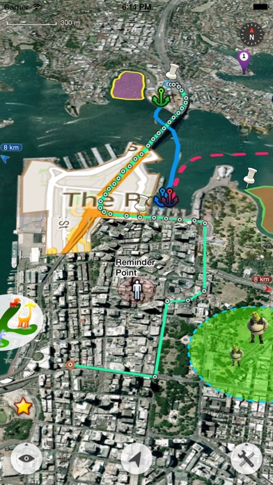
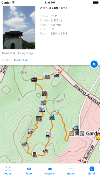
● You can also use Map Plus to help your outdoor activities and global travels, for trip planning, offline map downloading, track/photo/video recording, and sharing memories with friends.
Besides common map features such as locating, searching, Map Plus provides many more special:
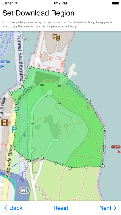
● Configuring, viewing and downloading any online maps of XYZ/WMS/WMTS patterns, or using scripts to configure more complex ones.
● Handling GIS vector file formats, such as Shape(SHP), TAB, GEOJSON, GML/GZ, AutoCAD DXF...
● Handling Common GIS file formats such as KML, KMZ, GPX, CSV, WPT.. Supported styles in KML/KMZ.
● Handling offline map file formats such as MBTiles, RMaps...
● On-map vector editing with finger drag-drop and magnetic snap.
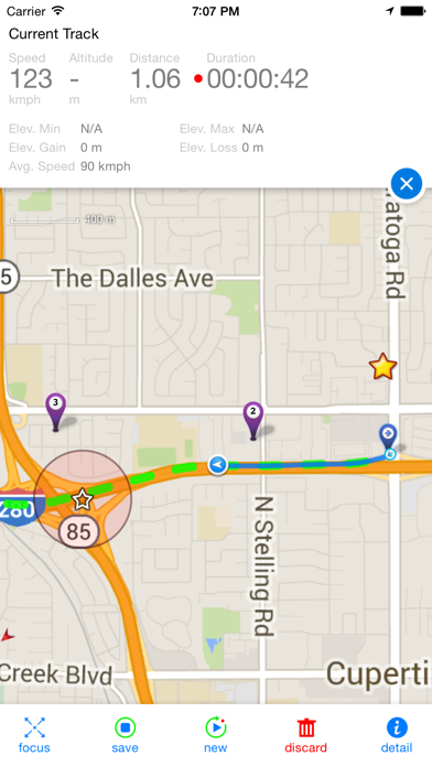
● GPS Track Recording with auto-recovery and background mode support.
● Path Following with voice guidance for both user paths and searched direction routes.
● Displaying locations of photos and videos in your system photo albums. (no need to import)
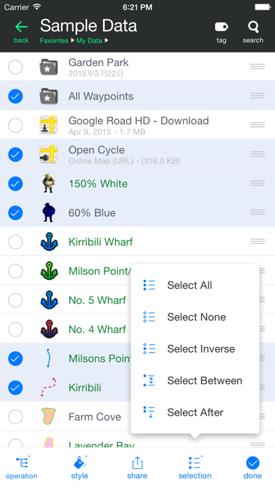
● User data management with folders, sub-folders, layers, bulk operations, shortcuts, tags and fuzzy searches. Supports Advanced Search by using expressions with attribute conditions.
● Using Feature Class for bulk editing and managing similar (same class of) features and layers all together. Supports bulk Attributes Merge and Link Relationship Building between features of different classes.
● Conditional Style and Expression provide dynamic content rendering.
● Customizable pop-up panel for on-map picking items with HTML, JS and CSS support to make custom forms, layout and rich-formatted content.
● Handling coordinates in MGRS, UTM, and Plus Code.
● Photo Markup allows you draw markups on photo, such as arrows, texts, free-hand drawings.
● Browser Access allows you to access app's data or files from a desktop PC/Mac with a web browser wirelessly.
● Sharing or transferring data via Wi-Fi, Bluetooth, iCloud, SMS, Email, QR codes, Open-In, AirDrop or many other ways.
● Many more fantastic and free functions could not be fully descriped here, such as Guide Mark, Arrival Notification, Photo Mode, Map Level Adjust, Custom Icons, Photo/Video Attachments, Image Overlay, Text Overlay, Fast Editing, Distance/Perimeter/Area Measuring, Custom Time Zone, etc.
User Manual:
https://duweis.com/en/mapplus_guide.html
User Forum:
https://duweis.com/forums/viewforum.php?f=13
Contact Us:
[email protected]
Hide.. Show more..

In-Apps

Donate
$2.99
Enhanced GIS
$6.99
Enhanced Map
$0.99
Enhanced Photo
$11.99
Enhanced Format
$3.99
Enhanced Editing
$7.99
Export GPX Support
$3.99
Large File Support
$0.99
Full-Function Package
$24.99
Remove Advertisements
$4.99

Screenshots

User Rating

4.6 out of 5

75 ratings in Canada

5 star
57
4 star
12
3 star
3
2 star
0
1 star
3
Ratings History

Map Plus Installs

Last 30 days

Map Plus Revenue

Last 30 days

Map Plus Reviews

Best map app hands down

gizmozigmo on

Canada

I use this app for planning and tracking cross-country cycling journeys. There’s a bit of a learning curve, but it’s worth it, because the app is not constantly sticking its nose into other parts of my life and for a few extra bucks, again, well worth it, doesn’t advertise garbage to me. How long will it last? Who knows! Let’s all just enjoy this unspoiled application actually designed for users over our corporate overlords while we can.

Not perfect, but best iOS GIS Mapping Software

marsofearth on

Canada

Still the best iOS Professional GIS mapping software by far. Have used for years in professional work, the most stable, dependable, useable and efficient professional mapping tool for ios. I would like to have forum support back, as there was a lot of good information there.

Best Mapping software for iOS

n0madam0n on

Canada

I have been using this software for years for offline mapping. I love the ability to add different online map URLS to get customer layers as well as the function to change transparency and use multiple map layers at the same time.

Offline MbTiles Map Support, and More

Brizoo on

Canada

Easy to use. Open MbTiles map directly from email. Love the user interface. Bravo!

good job

satimagegps on

Canada

support kml file easily !!

Meilleur appli

Dom8ich on

Canada

Très bonne compatibilité avec des programmes GIS Facile d’utilisation plus de 5ans d’utilisation. Bravo bon travail! Dom.

So far one of the best sources I’ve used

Dikwap on

Canada

For higher definition imagery, seems most of the available apps here are misleading and a waste of time

Route planning pal

gizmozigmo on

Canada

I looked at endless apps purporting to help with route planning for local cycling trips, all of them greedy bloatware. This little app does it all and it makes short work of it, including tracking actual progress once you’re out there. The interface takes a bit of getting used to, but every map function I can ever imagine needing is there. May this app have a good future for those of us who appreciate quality software and engineering.

Best iOS GIS app by far.

marsofearth on

Canada

Still the best GIS app for iOS mapping, location data acquisition, and ease of use. I have spent hundreds of dollars on so called “professional” iOS applications that end up buggy, feature poor, and frustrating to use. The Map Plus dev.s are active and constantly improving stability in areas I have not even had troubles in. The versatility of being able to import a large array of vector and raster file formats is fantastic. The only active request I can think of is to have the ability to import geoPDF files.

Favourite mapping app for backcountry

saltofthemar on

Canada

Love the whole app — it wasn’t long before I supported this project and upgraded to full capabilities. Map Plus is chocked full of every feature needed to build personal custom offline backcountry maps for quadding, paddling, hiking, exploring, whatever. There is no other app as fully featured that doesn’t require a user account and community subscription to all this stuff you don’t need. If you are willing to get a bit technical (read documentation to get an idea of capabilities) and simply want a GIS solution to work on your maps, routes and POIs in detail with offline access, use Map Plus. Using MOBAC on my laptop, I’ve been able to start assembling and downloading offline satellite maps at selected zoom levels of my area. I can also import route and POI data from my GPS device or track locally in app. Later I can split and modify all tracks, waypoints, POIs etc, to help me find places later or even get back home in the dark. Ability to import and export everything is so lovely, setting are detailed leaving nothing out. A huge shout out to developers for making this app, it’s simply the best.

Store Rankings

Ranking History
Category Rankings
Chart
Category
Rank
Top Grossing
34
Top Grossing
43
Top Grossing
50
Top Grossing
60
Top Grossing
62

Keywords

Map Plus Competitors

Map Plus Revenue and Downloads

Gain valuable insights into Map Plus performance with our analytics.
Sign up now to access downloads, revenue, and more.

App Info

Category
Navigation
Publisher
Miocool
Languages
English, Chinese, Chinese
Recent version
2.9.0 (5 months ago )
Released on
May 27, 2011 (13 years ago )
Last updated
4 days ago