
Description
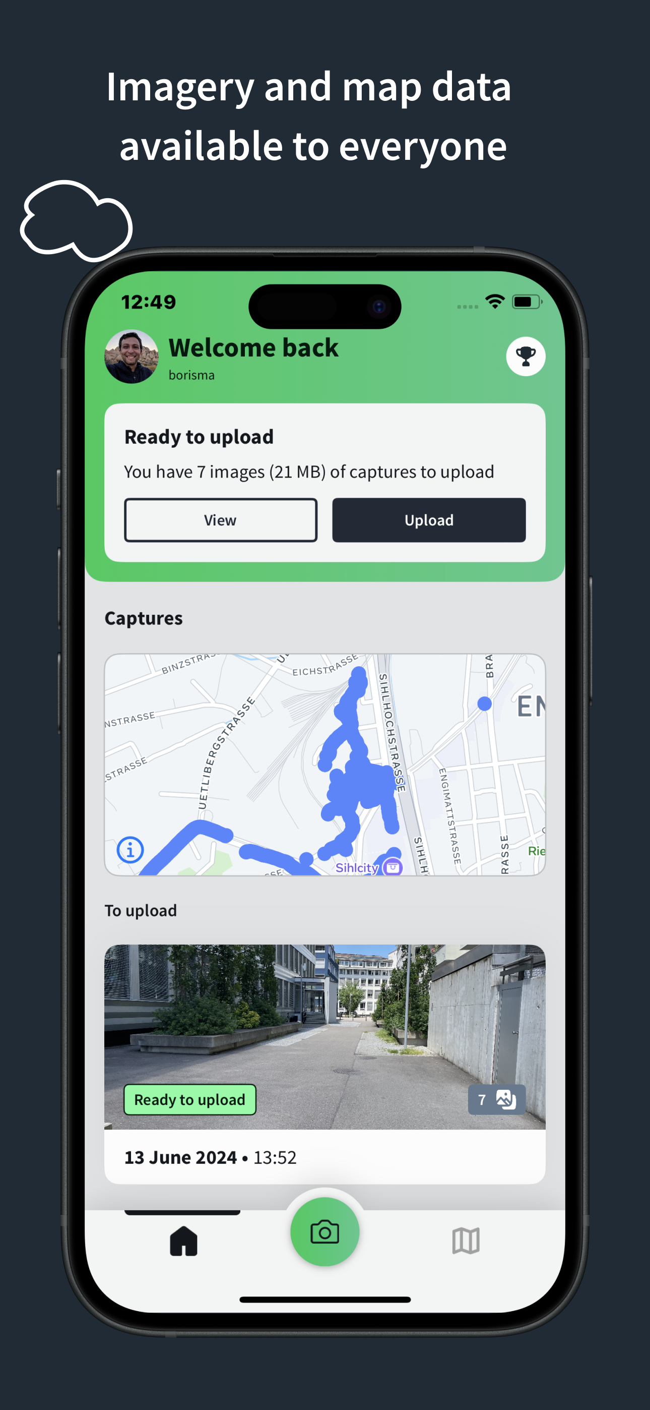
Mapillary is the street-level imagery platform that scales and automates mapping using collaboration, cameras, and computer vision.
Anyone can capture images of any place, as often as needed, with any camera—including smartphones. Mapillary combines all images into a collaborative street-level view of the world that’s available for anyone to explore and use for improving maps, cities, and mobility. Computer vision technology provides a smooth viewing experience and speeds up mapping through machine-extracted map data.
Capturing with the Mapillary mobile app is the easiest way to join our contributor network. Let’s get started!
CREATE YOUR OWN STREET-LEVEL VIEWS
You control when and where to capture to create the freshest street-level imagery. Mapillary’s technology combines all images into a navigable view and blurs faces and license plates for privacy.
ACCESS AND OPEN UP DATA
Mapillary contributors are people, organizations, companies, and governments in 190 countries. Millions of images are added to the dataset every week, which you can explore right here in the mobile app.
MAKE BETTER MAPS
Use imagery and machine-extracted data to add details to maps and geospatial datasets. Mapillary integrates with tools like OpenStreetMap iD editor and JOSM, HERE Map Creator, and ArcGIS. To access the available map data, go to mapillary.com/app.
Hide
Show More...
Anyone can capture images of any place, as often as needed, with any camera—including smartphones. Mapillary combines all images into a collaborative street-level view of the world that’s available for anyone to explore and use for improving maps, cities, and mobility. Computer vision technology provides a smooth viewing experience and speeds up mapping through machine-extracted map data.
Capturing with the Mapillary mobile app is the easiest way to join our contributor network. Let’s get started!
CREATE YOUR OWN STREET-LEVEL VIEWS
You control when and where to capture to create the freshest street-level imagery. Mapillary’s technology combines all images into a navigable view and blurs faces and license plates for privacy.
ACCESS AND OPEN UP DATA
Mapillary contributors are people, organizations, companies, and governments in 190 countries. Millions of images are added to the dataset every week, which you can explore right here in the mobile app.
MAKE BETTER MAPS
Use imagery and machine-extracted data to add details to maps and geospatial datasets. Mapillary integrates with tools like OpenStreetMap iD editor and JOSM, HERE Map Creator, and ArcGIS. To access the available map data, go to mapillary.com/app.
Screenshots


Mapillary FAQ
-
Is Mapillary free?
Yes, Mapillary is completely free and it doesn't have any in-app purchases or subscriptions.
-
Is Mapillary legit?
Not enough reviews to make a reliable assessment. The app needs more user feedback.
Thanks for the vote -
How much does Mapillary cost?
Mapillary is free.
-
What is Mapillary revenue?
To get estimated revenue of Mapillary app and other AppStore insights you can sign up to AppTail Mobile Analytics Platform.

User Rating
App is not rated in New Zealand yet.
Ratings History
Mapillary Reviews
No Reviews in New Zealand
App doesn't have any reviews in New Zealand yet.
Store Rankings
Ranking History
App Ranking History not available yet
Category Rankings
App is not ranked yet
Mapillary Competitors
| Name | Downloads (30d) | Monthly Revenue | Reviews | Ratings | Recent release | |
|---|---|---|---|---|---|---|

OsmAnd Maps Travel & Navigate
Top-rated mobile trip planner
|
View
|
View
|
4
|
|
4 days ago | |

Open GPX Tracker
No ads, no in-app purchases
|
View
|
View
|
0
|
|
1 year ago | |
OpenMaps - Topographic maps
Open source topographic maps
|
View
|
View
|
0
|
|
5 months ago | |

Organic Maps Offline Hike Bike
Trails, Travel, GPS Navigation
|
View
|
View
|
2
|
|
1 month ago | |

Street View - 3D Live Camera
GPS Route Finder & Navigation
|
View
|
View
|
0
|
|
1 year ago | |

ArcGIS Navigator
|
View
|
View
|
0
|
|
1 month ago | |

Street View 3D - 360° View
Street View - Maps & GPS
|
View
|
View
|
0
|
|
1 year ago | |

Every Door
OSM editor for POI & entrances
|
View
|
View
|
0
|
|
1 month ago | |

Street View Maps
Street Map Viewer
|
View
|
View
|
0
|
|
6 months ago | |

Mapply for Open Street Map
Street, Topo, Railway & Sea
|
View
|
View
|
0
|
|
7 months ago |
Mapillary Installs
Last 30 days
Mapillary Revenue
Last 30 daysMapillary Revenue and Downloads
Gain valuable insights into Mapillary performance with our analytics.
Sign up now to access downloads, revenue, and more.
Sign up now to access downloads, revenue, and more.
App Info
- Category
- Photo Video
- Publisher
- Mapillary
- Languages
- Arabic, Dutch, English, French, German, Hebrew (modern), Hindi, Hungarian, Indonesian, Italian, Japanese, Korean, Polish, Portuguese, Russian, Chinese, Spanish, Swedish, Thai, Chinese, Turkish, Ukrainian, Vietnamese
- Recent release
- 6.2.4 (2 weeks ago )
- Released on
- Nov 22, 2013 (11 years ago )
- Also available in
- United States, Austria, Australia, Ireland, Sweden, Mexico, Philippines, Peru, New Zealand, Norway, Netherlands, Nigeria, Malaysia, Portugal, Lebanon, Kazakhstan, Kuwait, South Korea, Pakistan, Poland, India, Romania, Russia, Saudi Arabia, Singapore, Thailand, Türkiye, Taiwan, Ukraine, Vietnam, South Africa, Algeria, Argentina, Azerbaijan, Belgium, Brazil, Belarus, Canada, Switzerland, Chile, Colombia, Czechia, Germany, Denmark, Dominican Republic, Japan, Ecuador, Egypt, Spain, Finland, France, United Kingdom, Greece, Hong Kong SAR China, Hungary, Indonesia, Israel, United Arab Emirates, Italy
- Last Updated
- 4 days ago
This page includes copyrighted content from third parties, shared solely for commentary and research in accordance with fair use under applicable copyright laws. All trademarks, including product, service, and company names or logos, remain the property of their respective owners. Their use here falls under nominative fair use as outlined by trademark laws and does not suggest any affiliation with or endorsement by the trademark holders.