
Memory-Map for All
Offline Mapping GPS Navigation
#1 Keyword Rankings
Today
Top 10 Rankings
Today
Top 30 Rankings
Today
Top 100 Rankings
Today
Description
Download maps for Offline GPS Navigation. No mobile data connection required.
Your favorite maps and charts from OS, Hema, NOAA, and many more.
Fully customizable map, data display and toolbar buttons.
Powerful overlay data management, using nested categories and GPX files
Backup and load maps from thumb drive.
Use the same maps and sync your overlay data to other mobile devices and desktop computers
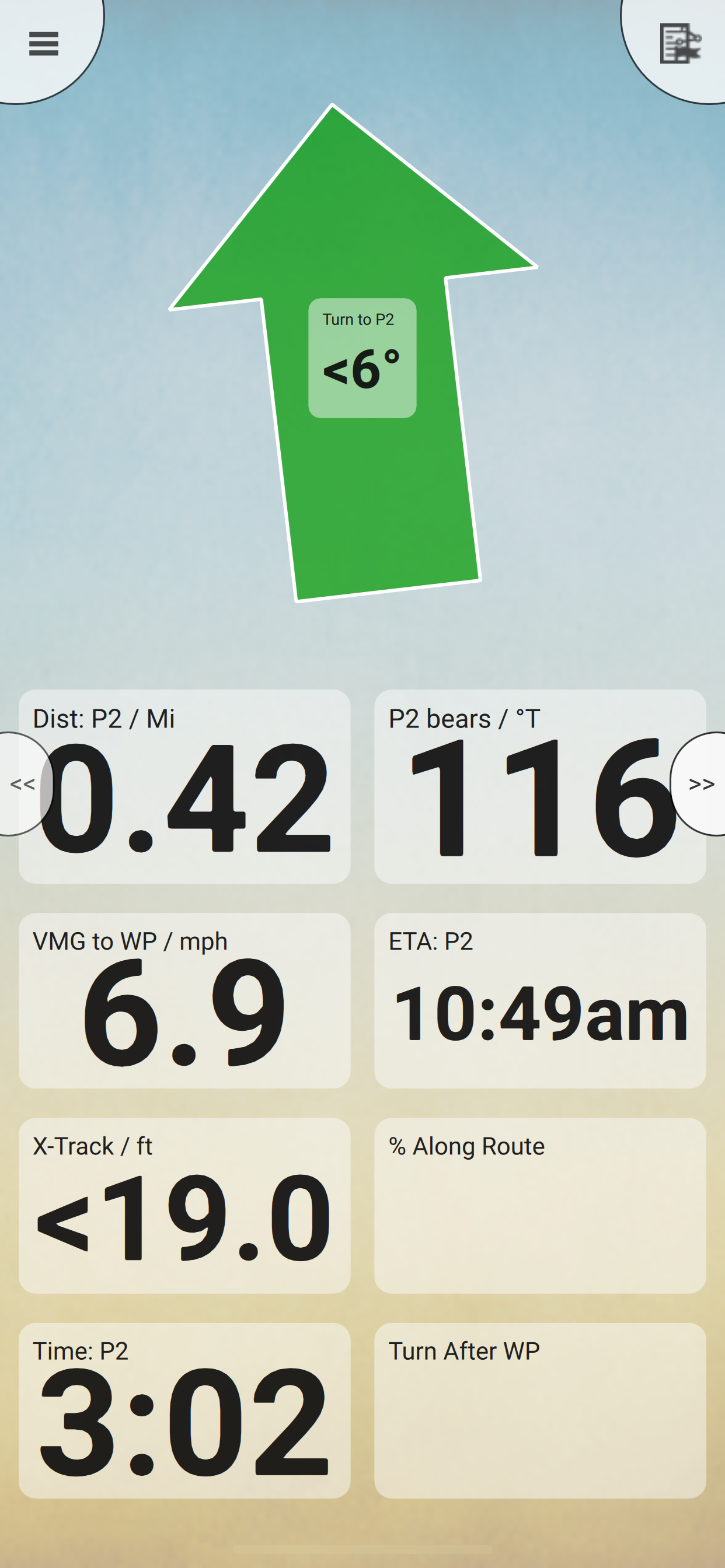
Interactive Route Profile showing terrain elevation
Track Altitude and Speed profile graphs
Show terrain ascent, descent, max elevation and estimated time for planned route
The Memory-Map for All app turns your phone or tablet into a full-featured Outdoor GPS or Marine Chart Plotter, and allows you to navigate with USGS Topo maps, NOAA Marine charts, and many other specialist maps, without needing a mobile internet signal.
Maps are downloaded on-the-fly and can be pre-loaded, so they are ready to be used offline. Once the app and maps are loaded to the phone or tablet, cellular network coverage or internet connection is not required for real time GPS navigation.
The Memory-Map for All app can be used as a standalone GPS navigator, but it can also be used in conjunction with the Windows PC or Mac app (free download) for planning, printing and loading up maps, waypoints and routes to the phone/tablet.
Memory-Map for All includes free access to 1:250,000 scale topographic maps and many other free maps around the world. More detailed maps are available for download and purchase with a free try-before-you-buy, time-limited demo option. Available maps include Ordnance Survey, Hema, USGS quads, NOAA, UKHO, and DeLorme. Maps can be used on your PC as well as your phone and tablet. The Cloud Sync feature allows you to keep the overlay data consistent on all your devices.
Features include:
Access a vast range of Worldwide maps and charts.
Automatically downloads a free map of your current location
Create and edit marks and routes.
Import and export marks, routes and tracks in the open GPX format
Interactive graphs of terrain elevation, GPS Altitude and Speed profile
Display; Position, Course, Speed, Heading, Altitude and averages
Position coordinates include Lat/Long, UTM, GB Grid, Irish Grid, Military Grid.
Units displayed in Statute, Nautical or Metric, with separate unit setting for Height
Support for GPS and Compass sensors, where available.
Placename search index can be used offline.
Moving map, lock GPS position and automatically scroll the map
Records breadcrumb trail / tracklogs.
Share position marks, routes and tracklogs as GPX files
Full marine instrumentation features, with AIS, DSC and Anchor alarm
NMEA data interface via WiFi
Barometer & relative altitude
Import custom icons for POI
Hide..
Show more..
Your favorite maps and charts from OS, Hema, NOAA, and many more.
Fully customizable map, data display and toolbar buttons.
Powerful overlay data management, using nested categories and GPX files
Backup and load maps from thumb drive.
Use the same maps and sync your overlay data to other mobile devices and desktop computers
Interactive Route Profile showing terrain elevation
Track Altitude and Speed profile graphs
Show terrain ascent, descent, max elevation and estimated time for planned route
The Memory-Map for All app turns your phone or tablet into a full-featured Outdoor GPS or Marine Chart Plotter, and allows you to navigate with USGS Topo maps, NOAA Marine charts, and many other specialist maps, without needing a mobile internet signal.
Maps are downloaded on-the-fly and can be pre-loaded, so they are ready to be used offline. Once the app and maps are loaded to the phone or tablet, cellular network coverage or internet connection is not required for real time GPS navigation.
The Memory-Map for All app can be used as a standalone GPS navigator, but it can also be used in conjunction with the Windows PC or Mac app (free download) for planning, printing and loading up maps, waypoints and routes to the phone/tablet.
Memory-Map for All includes free access to 1:250,000 scale topographic maps and many other free maps around the world. More detailed maps are available for download and purchase with a free try-before-you-buy, time-limited demo option. Available maps include Ordnance Survey, Hema, USGS quads, NOAA, UKHO, and DeLorme. Maps can be used on your PC as well as your phone and tablet. The Cloud Sync feature allows you to keep the overlay data consistent on all your devices.
Features include:
Access a vast range of Worldwide maps and charts.
Automatically downloads a free map of your current location
Create and edit marks and routes.
Import and export marks, routes and tracks in the open GPX format
Interactive graphs of terrain elevation, GPS Altitude and Speed profile
Display; Position, Course, Speed, Heading, Altitude and averages
Position coordinates include Lat/Long, UTM, GB Grid, Irish Grid, Military Grid.
Units displayed in Statute, Nautical or Metric, with separate unit setting for Height
Support for GPS and Compass sensors, where available.
Placename search index can be used offline.
Moving map, lock GPS position and automatically scroll the map
Records breadcrumb trail / tracklogs.
Share position marks, routes and tracklogs as GPX files
Full marine instrumentation features, with AIS, DSC and Anchor alarm
NMEA data interface via WiFi
Barometer & relative altitude
Import custom icons for POI
Screenshots


 User Rating
0 out of 5
0 ratings in Indonesia
Ratings History
Reviews
App doesn't have any reviews yet
Store Rankings
Ranking History
App Ranking History not available yet
Category Rankings
|
Chart
|
Category
|
Rank
|
|---|---|---|
|
Top Free
|

|
116
|
|
Top Free
|

|
243
|
|
Top Free
|

|
473
|
Keywords
Users may also like
| Name | Reviews | Recent release | |
|---|---|---|---|

Outside Maps
|
0
|
2 years ago | |

CamperMate Australia & NZ
Road trip map & campsite guide
|
1
|
1 month ago | |

4WD Maps - Offline Topo Maps
Offroad 4x4 GPS Navigation
|
0
|
1 year ago | |

OS Maps: Walk, Hike, Run, Bike
Route plan, map & GPS navigate
|
0
|
4 days ago | |

GPS OS Grid Reference
Great Britain and Ireland
|
0
|
2 years ago | |

BackCountry Navigator XE
Topo Maps and GPS for Outdoors
|
1
|
1 month ago | |

HiiKER: The Hiking Maps App
Hiking trails & walks near you
|
0
|
1 week ago | |

Raymarine
Mobile Companion for Raymarine
|
0
|
2 months ago | |

Tides Planner
|
2
|
6 months ago | |

Discover the Flinders Ranges
|
0
|
1 month ago |
Show More
Revenue and Downloads
Gain valuable insights into Memory-Map for All performance with our analytics. Sign up now
to
access downloads, revenue, and more.
App Info
- Category
- Navigation
- Publisher
- Memory-Map, Inc.
- Languages
- Recent version
- 1.3.1 (5 months ago )
- Released on
- May 26, 2022 (2 years ago )
- Also available in
- United Kingdom, Australia, United States, New Zealand, Austria, France, Canada, Switzerland, Germany, Malaysia, Philippines, Peru, Norway, Netherlands, Nigeria, Romania, Mexico, Lebanon, Kazakhstan, Kuwait, Pakistan, Poland, Portugal, India, Saudi Arabia, Sweden, Singapore, Thailand, Turkey, Taiwan, Ukraine, Vietnam, South Africa, Ecuador, Argentina, Azerbaijan, Belgium, Brazil, Chile, China, Colombia, Czechia, Denmark, Dominican Republic, Algeria, South Korea, Egypt, Spain, Finland, Greece, Hong Kong, Hungary, Indonesia, Ireland, Israel, United Arab Emirates, Italy, Russia, Japan
- Last updated
- 1 week ago