
Memory-Map
Topo Maps / Marine Charts
#1 Keyword Rankings
Today
Top 10 Rankings
Today
Top 30 Rankings
Today
Top 100 Rankings
Today
Description
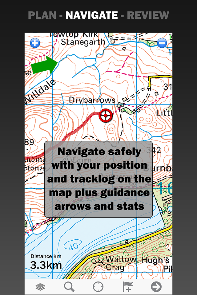
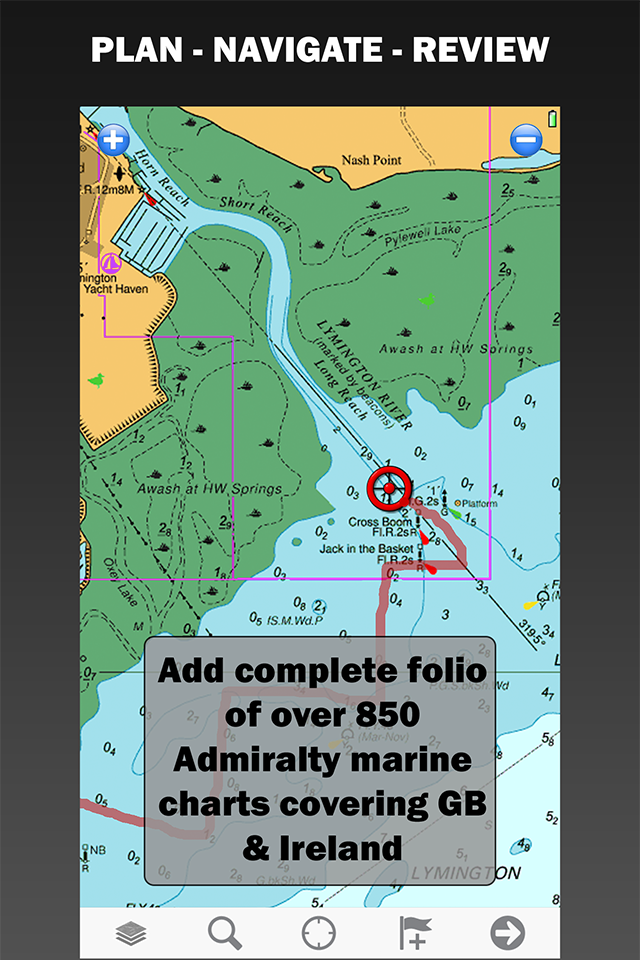
Turn your iPhone or iPad into an outdoor GPS or marine chart plotter, with the detailed Topo maps or NOAA marine charts needed for your activity. Maps are stored on the device for offline use, when you don't have any network connection. The GPS will show your location even where you have no mobile phone signal.
The app can be used standalone, but the maps and overlay data may also be used on your home PC or Mac for planning, and for printing maps on paper. Then upload everything to your phone or tablet and enjoy navigating outdoors with high quality maps.
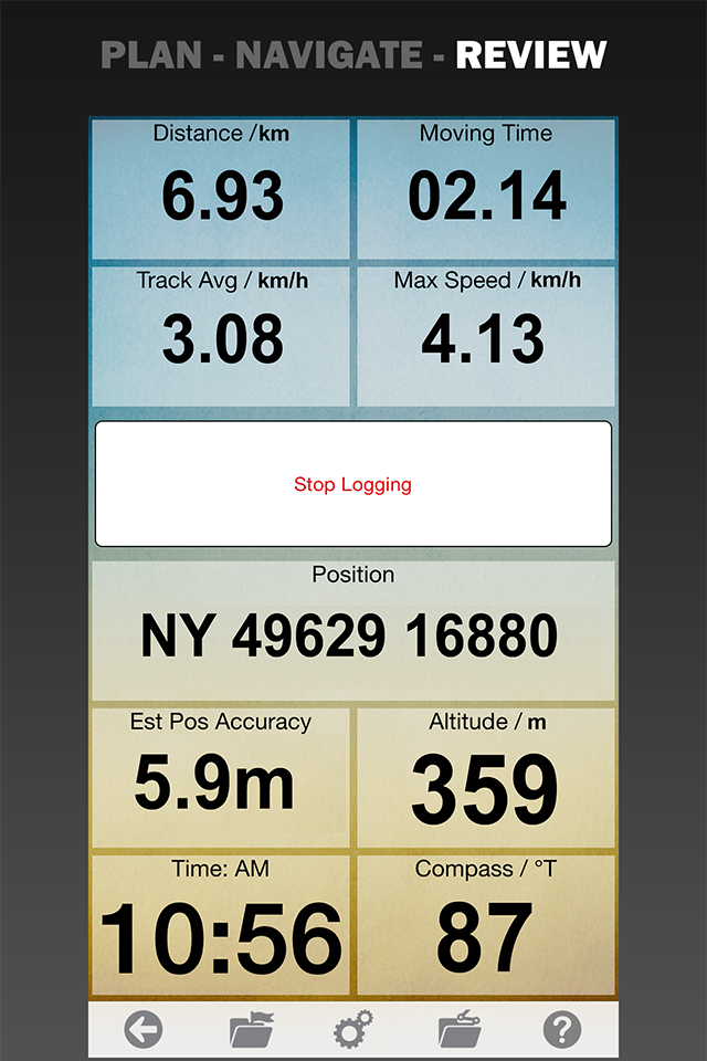
When you get home you can transfer your tracklog and points of interest back onto your computer, to see where you actually went, analyze your speed and elevation profile, and so on.
Whether you are fishing, paddling, backpacking, mountain biking or sailing, enjoy your time in the wilderness with Memory-Map. We have been developing mobile navigation apps since year 2000, and our products are trusted by mountain rescue teams, police and coast guard stations around the world.
Features:
+ Fast scrolling and zooming
+ Import and export GPX files
+ Screen lock to prevent accidental screen touches while recording a track
+ Shows speed and direction of travel, even while walking slowly
+ Support for GPS and Compass sensors, where available.
+ Placename index, works offline
+ Moving map, lock GPS position and automatically scroll the map
+ Records tracklogs with app running in the background
+ Create and edit marks, which may be linked to a web URL
+ Plan routes, measure distance and bearings
+ Routes snap to roads or trails, optimized for walking, cycling, or driving
+ Shows Altitude
+ Lat/Long, UTM, British National Grid and MGRS coordinate systems
+ Share position marks or tracklogs with other apps using GPX files
+ Connect to NMEA instruments and AIS via a WiFi gateway
+ AIS collision alarms, Anchor alarms and proximity alarms use notifications.
Battery Use Disclaimer: "Continued use of GPS running in the background can dramatically decrease battery life."
Hide..
Show more..
The app can be used standalone, but the maps and overlay data may also be used on your home PC or Mac for planning, and for printing maps on paper. Then upload everything to your phone or tablet and enjoy navigating outdoors with high quality maps.
When you get home you can transfer your tracklog and points of interest back onto your computer, to see where you actually went, analyze your speed and elevation profile, and so on.
Whether you are fishing, paddling, backpacking, mountain biking or sailing, enjoy your time in the wilderness with Memory-Map. We have been developing mobile navigation apps since year 2000, and our products are trusted by mountain rescue teams, police and coast guard stations around the world.
Features:
+ Fast scrolling and zooming
+ Import and export GPX files
+ Screen lock to prevent accidental screen touches while recording a track
+ Shows speed and direction of travel, even while walking slowly
+ Support for GPS and Compass sensors, where available.
+ Placename index, works offline
+ Moving map, lock GPS position and automatically scroll the map
+ Records tracklogs with app running in the background
+ Create and edit marks, which may be linked to a web URL
+ Plan routes, measure distance and bearings
+ Routes snap to roads or trails, optimized for walking, cycling, or driving
+ Shows Altitude
+ Lat/Long, UTM, British National Grid and MGRS coordinate systems
+ Share position marks or tracklogs with other apps using GPX files
+ Connect to NMEA instruments and AIS via a WiFi gateway
+ AIS collision alarms, Anchor alarms and proximity alarms use notifications.
Battery Use Disclaimer: "Continued use of GPS running in the background can dramatically decrease battery life."
In-Apps
- Norway Topo
- USD 27.99
- Stardard Sync
- USD 9.99
- OS StreetView 2015
- USD 16.99
- DeLorme Topo Map WY
- USD 19.99
- Professional Features
- USD 49.99
- UK Marine Charts 2014
- USD 35.99
- Classic Map Compatibility
- USD 19.99
- OS 1:50,000 Landranger topo map, 2015 edition
- USD 79.99
- OS 1:50,000 Landranger topo map, HD 2015 edition
- USD 94.99
- OS 1:50,000 Landranger topo map, HD 2016 edition
- USD 99.99
Screenshots


 User Rating
0 out of 5
0 ratings in Azerbaijan
Ratings History
Reviews
App doesn't have any reviews yet
Store Rankings
Ranking History
App Ranking History not available yet
Category Rankings
|
Chart
|
Category
|
Rank
|
|---|---|---|
|
Top Free
|

|
250
|
|
Top Free
|

|
291
|
|
Top Free
|

|
458
|
|
Top Free
|

|
468
|
Keywords
Users may also like
| Name | Reviews | Recent release | |
|---|---|---|---|

4WD Maps - Offline Topo Maps
Offroad 4x4 GPS Navigation
|
0
|
1 year ago | |

WikiCamps Australia
Find campsites & caravan parks
|
0
|
2 weeks ago | |

Camps Australia Wide
#1 Campsite & Caravan Park App
|
0
|
2 weeks ago | |

ExplorOz Traveller
Offroad Australia offline maps
|
0
|
3 weeks ago | |

NSW National Parks
Guides and maps for visitors
|
0
|
2 months ago | |

Anycamp
Find campsites in Australia
|
0
|
2 months ago | |

Billy Goat Offroad
4WD & Camping Map of Australia
|
0
|
2 weeks ago | |

4x4 Explorer
Hema Maps 4x4 Explorer
|
0
|
1 week ago | |

Dirt Map - Smart Outdoor Map
Topo app - 4x4, Hike, MTB, Run
|
0
|
5 months ago | |

Imray Navigator
|
0
|
1 year ago |
Show More
Revenue and Downloads
Gain valuable insights into Memory-Map performance with our analytics. Sign up now
to
access downloads, revenue, and more.
App Info
- Category
- Navigation
- Publisher
- Memory-Map, Inc.
- Languages
- English
- Recent version
- 2.4.0 (2 years ago )
- Released on
- Feb 10, 2010 (14 years ago )
- Also available in
- United Kingdom, Australia, New Zealand, United States, France, Ireland, Canada, Germany, Spain, Netherlands, Russia, Sweden, Denmark, Mexico, Portugal, Italy, Dominican Republic, China, Turkey, Switzerland, Taiwan, Brazil, Norway, Nigeria, Malaysia, Peru, Saudi Arabia, Philippines, Pakistan, Poland, Romania, India, Singapore, Thailand, Ukraine, Vietnam, South Africa, Finland, Argentina, Austria, Azerbaijan, Belgium, Belarus, Chile, Colombia, Czechia, Algeria, Ecuador, Egypt, Lebanon, Greece, Hong Kong, Hungary, Indonesia, Israel, United Arab Emirates, Japan, South Korea, Kuwait, Kazakhstan
- Last updated
- 1 month ago