
NRDS Mobile Mapping ('Āina)
Mapping & Data Collection
#1 Keyword Rankings
Today
Top 10 Rankings
Today
Top 30 Rankings
Today
Top 100 Rankings
Today
Description
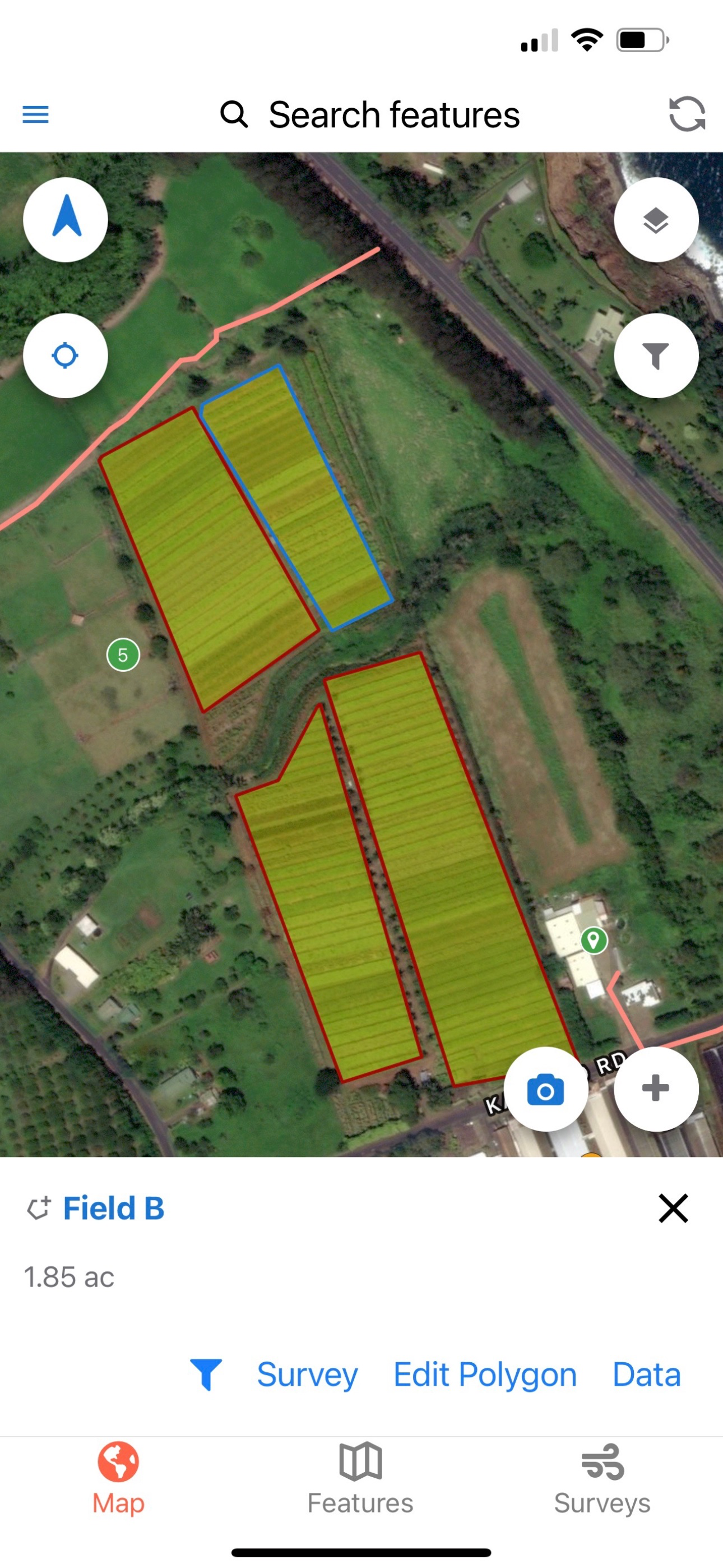
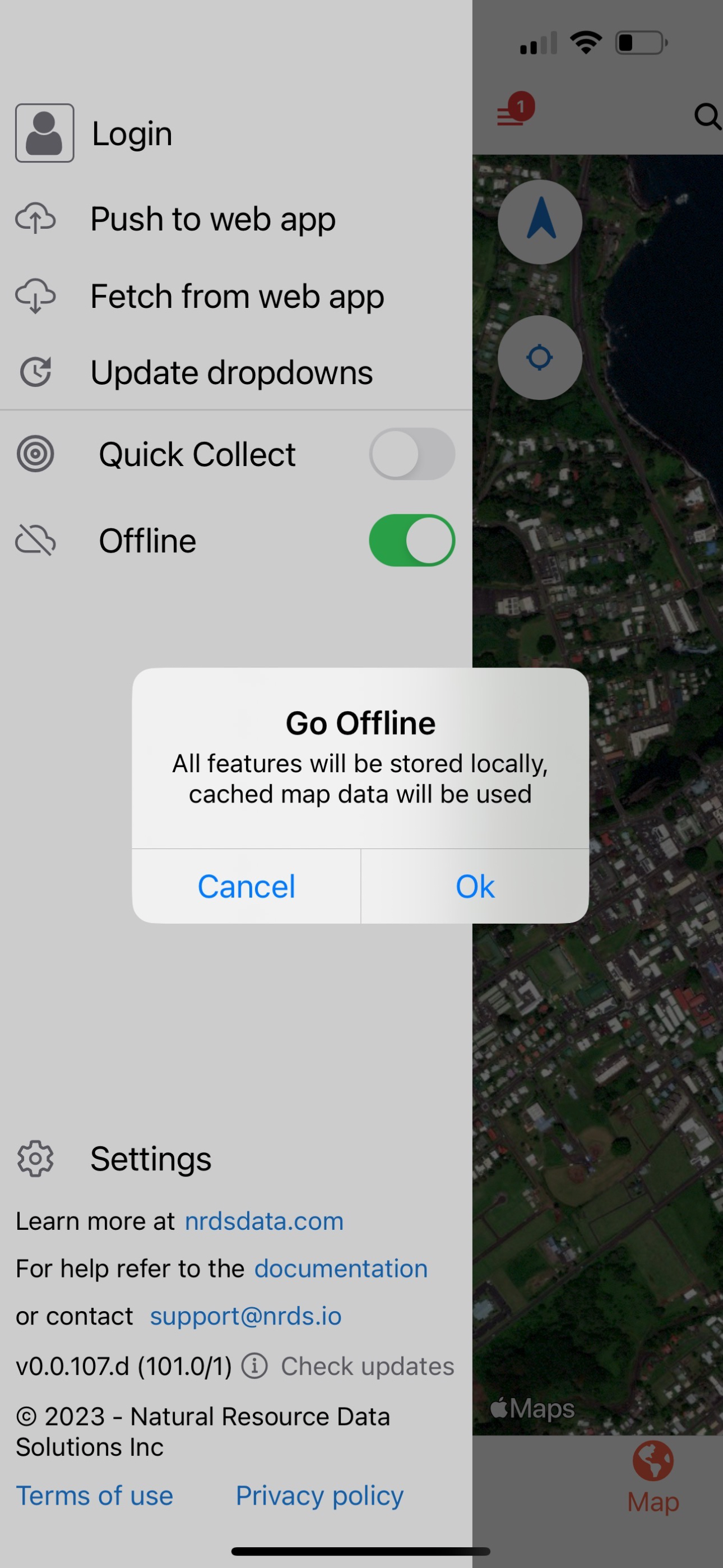
Mapping and data collection has never been more easy, accurate, and efficient. Geotag photos, record tracks, save waypoints, trace lines, draw polygons, and so much more with the NRDS app. Utilizing your device’s GPS, this mapping and data collection tool works both on and offline. Working in conservation or agriculture? Doing some surveying or hiking? This dependable app is designed for you.
ENHANCE YOUR NRDS CAPABILITIES
With credentials you can sync data to the nrds.io web platform and access features including but not limited to:
• Develop comprehensive reports
• Track work hours
• Share data between partners
• Bulk data uploads and exports
• Design downloadable surveys
• Organize your GIS features
• Manage users, teams, and contact lists
• Browse your photo gallery
• Build projections
Hide..
Show more..
ENHANCE YOUR NRDS CAPABILITIES
With credentials you can sync data to the nrds.io web platform and access features including but not limited to:
• Develop comprehensive reports
• Track work hours
• Share data between partners
• Bulk data uploads and exports
• Design downloadable surveys
• Organize your GIS features
• Manage users, teams, and contact lists
• Browse your photo gallery
• Build projections
Screenshots


 User Rating
0 out of 5
0 ratings in Canada
Ratings History
Reviews
App doesn't have any reviews yet
Store Rankings
Ranking History
App Ranking History not available yet
Category Rankings
App is not ranked yet
Keywords
Users may also like
| Name | Reviews | Recent release | |
|---|---|---|---|

Easy_GPS
|
1
|
1 year ago | |
MyGIS
Your Navigation Companion
|
0
|
6 months ago | |

Scuba Fish Hawaii
Fish ID for scuba divers
|
0
|
2 months ago | |
Ocean Alert
Be an ocean scientist!
|
0
|
2 years ago | |

Pro Altimeter - Barometric+GPS
Manual/GPS/METAR Calibration
|
1
|
4 months ago | |

GeoNames Map Explorer
Mapping and data collection
|
0
|
1 year ago | |

Palmyra Atoll Nature Guide
Fish Birds Crabs Coral Seaweed
|
1
|
2 years ago | |

The Kauai Bus Tracker
Moving Kauai With Aloha
|
0
|
2 years ago | |

Snorkel Fish Hawaii for iPhone
Fish ID for snorkelers
|
0
|
2 months ago | |

Ithaca Carshare
Unlock your local car share
|
0
|
3 months ago |
Show More
Revenue and Downloads
Gain valuable insights into NRDS Mobile Mapping ('Āina) performance with our analytics. Sign up now
to
access downloads, revenue, and more.
App Info
- Category
- Navigation
- Publisher
- Natural Resource Data Solutions Inc.
- Languages
- English
- Recent version
- 42 (2 months ago )
- Released on
- Jul 4, 2018 (6 years ago )
- Also available in
- United States, Russia, Poland, Hong Kong, Indonesia, Japan, Kuwait, Lebanon, Nigeria, Netherlands, Peru, Italy, Romania, Saudi Arabia, Singapore, Thailand, Ukraine, South Africa, Belarus, Canada, Switzerland, Chile, China, Colombia, Czechia, Germany, Dominican Republic, Algeria, Ecuador, Spain, Australia, Greece, Austria, Taiwan, Brazil, Mexico, Kazakhstan, South Korea, Argentina, France
- Last updated
- 1 week ago