
NRST
Descent Rate & Airport Finder
#1 Keyword Rankings
Today
Top 10 Rankings
Today
Top 30 Rankings
Today
Top 100 Rankings
Today
Description
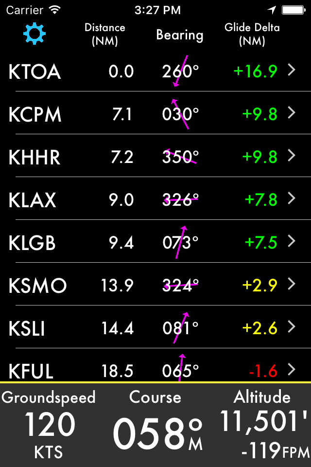
Don't miss your airport! Designed for pilots of any size aircraft, this app provides you with bearing and vertical speed required to nearby airports. The following information is shown for destinations:
• Distance from current location
• Field Elevation
• Descent rate required
• Time to Top of Descent (TOD)
• Bearing
• Frequencies
• Runways
• Glide distance delta
Additionally your current speed, course, altitude and vertical speed are displayed. Tapping on the information button, Time to TOD or Target Altitude allows you to customize the desired descent rate.
All data is updated in real time as you fly. You may choose a nearby airport or select an airport by identifier by scrolling down on the airport list. Filter by runway length and surface type and choose any of the following: airports, seaplane bases, heliports, balloon ports and closed airports.
You may optionally provide a glide ratio for your aircraft. The glide distance long or short of the selected airport is then displayed and is conveniently color coded. A positive, green glide delta indicates the glide distance has been estimated to exceed the distance to the airport with a 25% safety margin.
Runway headings, if known, are used to draw runways on the heading indicator. If the magenta arrow is pointed straight up and aligned with a runway then you are headed straight in.
Worldwide airport information is provided by multiple sources. Canada, Europe and all continents are covered! For more information go to ourairports.com/world.html. Database updates are performed daily.
Your location and altitude is provided by your device's location services. If location or altitude is not available that information will not be displayed however you can still search for an airport by identifier. Unfortunately external GPS devices are generally NOT compatible.
You must be moving for course information and the magenta relative bearing arrow to be displayed.
The Watch app has many of the same features and fits on your wrist. See distances to nearby airports or bearing to a selected airport. Frequencies and runway lengths can be seen with a swipe. A green glide icon or delta indicates glideability is likely.
Just like the iPhone and iPad app, the Watch app requires GPS information to locate nearby airports and relative bearing. Additionally, altitude is needed to calculate descent rates.
Feedback and feature requests are appreciated. Thanks!
Subscription Fine Print
----------------------
- 1 month FREE trial
- Database Subscription or Apple Watch Subscription is required for new users
- The subscription is for 1 year and updated data is available daily
- The annual subscription is $11.99/year or $17.99/year for Watch
- Payment will be charged to iTunes Account at confirmation of purchase
- Subscription automatically renews unless auto-renew is turned off at least 24-hours before the end of the current period
- Account will be charged for renewal within 24-hours prior to the end of the current period, and identify the cost of the renewal
- Subscriptions may be managed by the user and auto-renewal may be turned off by going to the user's Account Settings after purchase
- No cancellation of the current subscription is allowed during active subscription period
- Privacy policy and terms of use are located at: http://toonsy.net/privacy.html
- Any unused portion of a free trial period, if offered, will be forfeited when the user purchases a subscription to that publication.
Hide..
Show more..
• Distance from current location
• Field Elevation
• Descent rate required
• Time to Top of Descent (TOD)
• Bearing
• Frequencies
• Runways
• Glide distance delta
Additionally your current speed, course, altitude and vertical speed are displayed. Tapping on the information button, Time to TOD or Target Altitude allows you to customize the desired descent rate.
All data is updated in real time as you fly. You may choose a nearby airport or select an airport by identifier by scrolling down on the airport list. Filter by runway length and surface type and choose any of the following: airports, seaplane bases, heliports, balloon ports and closed airports.
You may optionally provide a glide ratio for your aircraft. The glide distance long or short of the selected airport is then displayed and is conveniently color coded. A positive, green glide delta indicates the glide distance has been estimated to exceed the distance to the airport with a 25% safety margin.
Runway headings, if known, are used to draw runways on the heading indicator. If the magenta arrow is pointed straight up and aligned with a runway then you are headed straight in.
Worldwide airport information is provided by multiple sources. Canada, Europe and all continents are covered! For more information go to ourairports.com/world.html. Database updates are performed daily.
Your location and altitude is provided by your device's location services. If location or altitude is not available that information will not be displayed however you can still search for an airport by identifier. Unfortunately external GPS devices are generally NOT compatible.
You must be moving for course information and the magenta relative bearing arrow to be displayed.
The Watch app has many of the same features and fits on your wrist. See distances to nearby airports or bearing to a selected airport. Frequencies and runway lengths can be seen with a swipe. A green glide icon or delta indicates glideability is likely.
Just like the iPhone and iPad app, the Watch app requires GPS information to locate nearby airports and relative bearing. Additionally, altitude is needed to calculate descent rates.
Feedback and feature requests are appreciated. Thanks!
Subscription Fine Print
----------------------
- 1 month FREE trial
- Database Subscription or Apple Watch Subscription is required for new users
- The subscription is for 1 year and updated data is available daily
- The annual subscription is $11.99/year or $17.99/year for Watch
- Payment will be charged to iTunes Account at confirmation of purchase
- Subscription automatically renews unless auto-renew is turned off at least 24-hours before the end of the current period
- Account will be charged for renewal within 24-hours prior to the end of the current period, and identify the cost of the renewal
- Subscriptions may be managed by the user and auto-renewal may be turned off by going to the user's Account Settings after purchase
- No cancellation of the current subscription is allowed during active subscription period
- Privacy policy and terms of use are located at: http://toonsy.net/privacy.html
- Any unused portion of a free trial period, if offered, will be forfeited when the user purchases a subscription to that publication.
In-Apps
- Device Only
- S/ 38.90
- Device and Watch
- S/ 57.90
- Early Adopter Device Subscription
- S/ 2.90
- Early Adopter Device and Watch Bronze
- S/ 6.50
Screenshots


 User Rating
0 out of 5
0 ratings in Peru
Ratings History
Reviews
App doesn't have any reviews yet
Store Rankings
Ranking History
App Ranking History not available yet
Category Rankings
|
Chart
|
Category
|
Rank
|
|---|---|---|
|
Top Grossing
|

|
94
|
Keywords
Users may also like
| Name | Reviews | Recent release | |
|---|---|---|---|

Levil Aviation
Digital Instrument Panel
|
0
|
1 month ago | |

SkyTimer
Flight Timer & Fuel Computer
|
0
|
6 months ago | |

Xavion
|
0
|
1 month ago | |

FlyGo Air Navigation
Aviation App for Pilots
|
0
|
1 month ago | |

PlaneWatcher
Flight Tracking on your Watch
|
0
|
3 years ago | |

SocialFlight
|
0
|
3 months ago | |

Sporty's E6B Flight Computer
Calculator for pilots
|
0
|
4 months ago | |

AltitudeAlert
Advanced Altitude Management
|
0
|
3 months ago | |

AOPA Mags
|
0
|
1 year ago | |

Stratus Horizon Pro
AHRS & Radio Transcription
|
0
|
3 months ago |
Show More
Revenue and Downloads
Gain valuable insights into NRST performance with our analytics. Sign up now
to
access downloads, revenue, and more.
App Info
- Category
- Navigation
- Publisher
- Toonsy Net
- Languages
- English
- Recent version
- 7.3 (5 months ago )
- Released on
- Mar 7, 2014 (10 years ago )
- Also available in
- United States, Germany, Australia, United Kingdom, Canada, Chile, Malaysia, Philippines, Peru, New Zealand, Norway, Netherlands, Nigeria, Romania, Mexico, Lebanon, Kazakhstan, Kuwait, South Korea, Pakistan, Poland, Portugal, India, Russia, Saudi Arabia, Sweden, Singapore, Thailand, Turkey, Taiwan, Ukraine, Vietnam, South Africa, Ecuador, Argentina, Austria, Azerbaijan, Belgium, Brazil, Belarus, Switzerland, China, Colombia, Czechia, Denmark, Dominican Republic, Algeria, Japan, Egypt, Spain, Finland, France, Greece, Hong Kong, Hungary, Indonesia, Ireland, Israel, United Arab Emirates, Italy
- Last updated
- 1 month ago