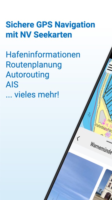
Enhance your navigation experience with a seamless navigation solution that provides up-to-date digital nautical charts, comprehensive harbour information, and a full suite of navigation features.
The charts can be downloaded for offline use and offer exceptional compatibility with the NV Charts paper charts with a similar chart design.
All currently valid editions of the NV Verlag / NV Charts nautical charts or inland charts | North Sea | Baltic Sea | Netherlands | Wadden Sea | Ijsselmeer | Sweden | Denmark | Germany | Norway | France | USA | Caribbean | Bahamas areas are compatible with the NV Charts App.
Enjoy the best of both worlds - paper and digital: A perfect match is our popular combination package of high-quality digital charts and cleverly designed paper charts. Alternatively, you can also purchase digital nautical charts directly via the app with a convenient annual subscription that renews automatically. The integrated update service keeps the charts up to date.
If it is not yet clear where the journey should go or no offline charts are activated, free online charts can be displayed for all NV Charts chart areas, even without a currently valid chart licence.
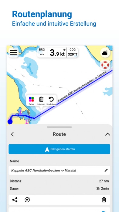
Detailed and relevant information is essential for navigating safely on the water. With the NV Charts App, you are part of the BoatView community yourself. You can mark harbours, anchorages and navigation warnings on the digital nautical chart and also add pictures of interesting places that go beyond navigation, such as restaurants or popular attractions, and share them with the community. Others can respond directly with comments. The continuously edited content can be downloaded directly to be available offline. To make all the information easily accessible, the app offers a search function. You can explore the surroundings and search directly for place names as well as anchorages, harbours, ramps, waypoints, cranes, fuel stations or tide stations. The app also offers fast and flexible auto-routing, allowing you to navigate directly to your destination and edit a route manually.
Navigation on board is even more fun together! You can share your tracks with friends or use the data outside the app and export it as a GPX file. You can easily share your favourite harbours and anchorages from the app via a link and coordinate your trip planning even better with everyone.
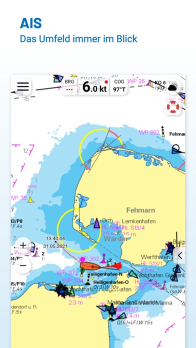
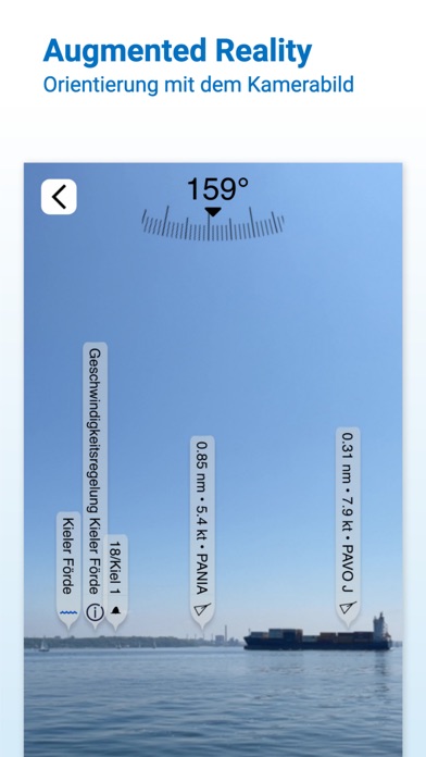
The AIS function in the NV Charts App allows you to keep an eye on AIS signals in real time. A WiFi AIS receiver can be connected to the NV Charts App for this purpose. The AIS Class A and B targets and aids to navigation (ATON), as well as MOB AIS SART transponder emergency transmitters, are displayed, and the traffic situation can be better assessed.
The NV Charts App can be installed and synchronized on multiple devices.
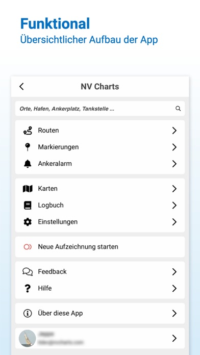
NV Charts App - Features:
+ Search function
+ Autorouting (Europe + other regions following soon)
+ Velocity Made Good (VMG)
+ Community Layer / Points of Interest(POI)
+ Free online boating charts preview for planning
+ In App Purchases of digital offline charts
+ Community Layer / Points of Interest(POI)
+ Reads all NV Chart chart areas
+ Easy download of the maps
+ Always the latest data
+ Seamless zoom and panning functions
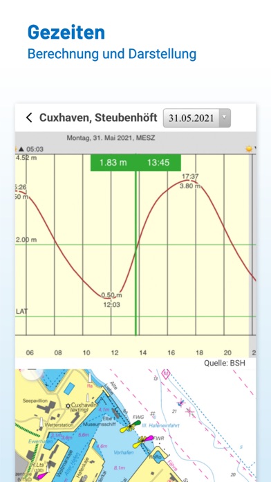
+ Tide Forecast
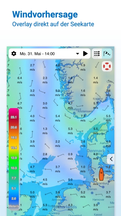
+ Online weather
+ AIS Wifi Support
+ AIS Sart Beacon
+ AIS CPA function
+ Night mode
+ Anchor alarm
+ Position with GPS
+ Intuitive route planning
+ Course markings, markings, bearing ruler
+ Port information
+ Display of instruments
+ Synchronizing devices
+ Live Position Sharing
+ Social sharing of routes, tracks, positions
Note:
Continued use of GPS in the background can significantly reduce battery life.
HideShow More...
In-Apps
Nordsee
CHF 51.00
Kroatien
CHF 51.00
Niederlande
CHF 51.00
Binnenreviere
CHF 51.00
Mittelmeer Ost
CHF 51.00
Mittelmeer West
CHF 51.00
Frankreich Atlantik
CHF 51.00
Karibik und Bermuda
CHF 51.00
Ostsee und Kattegat
CHF 51.00
Griechische Inseln und Küste
CHF 50.00
Screenshots
NV Charts GPS Navigation AIS FAQ
Is NV Charts GPS Navigation AIS free?
Yes, NV Charts GPS Navigation AIS is free to download, however it contains in-app purchases or subscription offerings.
Is NV Charts GPS Navigation AIS legit?
⚠️ The NV Charts GPS Navigation AIS app has poor ratings and negative feedback. Users seem unsatisfied with its performance or features.
Thanks for the vote
How much does NV Charts GPS Navigation AIS cost?
NV Charts GPS Navigation AIS has several in-app purchases/subscriptions, the average in-app price is CHF 50.90.
What is NV Charts GPS Navigation AIS revenue?
To get estimated revenue of NV Charts GPS Navigation AIS app and other AppStore insights you can sign up to AppTail Mobile Analytics Platform.
User Rating
4.39 out of 5
100 ratings in Switzerland
5 star
64
4 star
22
3 star
4
2 star
3
1 star
5
Ratings History
NV Charts GPS Navigation AIS Reviews
Code für digitale Nutzung der Karten wird nicht direkt zur Verfügung gestellt
Freischaltung der digital erworbenen Karte nicht möglich trotz Bezahlung, keine Antwort auf Email. App daher nicht nutzbar für mich. Ev. kommt der Code zum Freischalten auf dem Postweg, wenn die Papierversion geliefert wird. Sehr ärgerlich im Urlaub, da der Kauf des Kombipakets (Papier und digital) sinnlos war. Es sollte klar kommuniziert werden, dass das digitale Kartenmaterial nicht direkt nutzbar ist. Ich hätte sonst den Kauf sicher nicht durchgeführt, da ich die digitale Karte im Urlaub direkt nutzen wollte.
Immer instabiler
Die App ist prinzipiell sehr gut gemacht, ABER:
sie läuft zunehmend langsamer und stürzt inzwischen bei fast jedem Start ab. Der Support gab Empfehlungen, keine andere App parallel laufen zu lassen und das neueste iPhone einzusetzen. Das mache ich bereits mit dem iPhone meiner Frau ( iPhone 14). Trotzdem langsam und instabil.
Wenn die Entwickler bis nächstes Jahr nicht grundlegend etwas verbessern, werde ich auf Navionics umsteigen.
Adora
Super Sache
Sehr gute Infos
Die Karten sind sehr gut und informativ gestaltet. Die zusätzlichen Infoseiten zu den Häfen und den Sehenswürdigkeiten der entsprechenden Orte/Städte sind sehr gut und umfangreich. Bei den AIS-Angaben zu den Schiffen fehlt leider das Heimatland.
Karten
Die Navigationsgrundlage ist eine Papierkarte die beim einzoomen pixelig wird und keine ausreichende Informationstiefe insbesondere zu Tiefgang und anderer wichtiger Infos bietet. Nicht zu gebrauchen! Kein Testabo möglich, es werden direkt 40 Euro für ein Jahresabo der Offlinekarte fällig.
Schlechte Software
Ich will nichts gegen das Kartenmaterial sagen. Aber die Software ist einfach nur schlecht. iPhone 11 Pro: unbenutzbar, iPad Air 5 (M1) geht, aber nicht zuverlässig, iPhone 15 „zu wenig Arbeitsspeicher, kaufen Sie ein neues Gerät“ 🤦 Selbst auf meinem MacBook Pro, M1 Pro, 32 GB RAM läuft die App nicht so flüssig, wie sie sollte. Ist es mit QT nicht möglich, perfomante Software zu schreiben?
Lesbarkeit
Das Kartenbild ist wesentlich besser geworden. Variabele Schrift und Tonnengröße super 👍
software gaukelt hardwareprobleme vor
zu oft die Meldung, dass der Arbeitsspeicher nicht reicht. Mehr als mein tablet hat geht aber nicht
Zuerst begeistert am zweiten Tag absolut entsetzt
Ich habe die App gestern installiert und war begeistert von den Karten. Heute geht gar nix mehr. Erst wurden keine Karten mehr angezeigt, dann habe ich neu installiert aus dem AppStore. Jetzt meldet die dumme App keine Internetverbindung obwohl ich gerade ja die App runter geladen habe. Gestern ging Sie einwandfrei. Es gab kein Update also kann ich diesen Quatsch nicht erklären. Nicht mal das neu installieren hilft. Was ist das? Bloß gut das ich noch kein Abo abgeschlossen habe, das wird wohl auch so bleiben !
War mal besser
Seit dem Update Frühjahr 24 kein Autorouting mehr, nur noch Luftlinie. Ständig Warnungen wg. mangelndem Arbeitsspeicher. Immer wieder Abstürze. Egal, welches iOS Gerät. Für ernsthafte Navigation unbrauchbar.
Letztes Jahr lief die App auf älteren Geräten problemlos.
Schade, denn die Karten sind sehr gut. Support antwortet nicht und die FAQs helfen auch nicht weiter-> ein Kunde weniger. Leider wurde das Abo gerade erneuert, allerdings zum letzten Mal, wenn sich nichts ändert.