NV Charts GPS Navigation AIS
Marine Navigation and Boating
#1 Keyword Rankings
Today
Top 10 Rankings
Today
Top 30 Rankings
Today
Top 100 Rankings
Today

Description

Enhance your navigation experience with a seamless navigation solution that provides up-to-date digital nautical charts, comprehensive harbour information, and a full suite of navigation features.

The charts can be downloaded for offline use and offer exceptional compatibility with the NV Charts paper charts with a similar chart design.

All currently valid editions of the NV Verlag / NV Charts nautical charts or inland charts | North Sea | Baltic Sea | Netherlands | Wadden Sea | Ijsselmeer | Sweden | Denmark | Germany | Norway | France | USA | Caribbean | Bahamas areas are compatible with the NV Charts App.

Enjoy the best of both worlds - paper and digital: A perfect match is our popular combination package of high-quality digital charts and cleverly designed paper charts. Alternatively, you can also purchase digital nautical charts directly via the app with a convenient annual subscription that renews automatically. The integrated update service keeps the charts up to date.

If it is not yet clear where the journey should go or no offline charts are activated, free online charts can be displayed for all NV Charts chart areas, even without a currently valid chart licence.

Detailed and relevant information is essential for navigating safely on the water. With the NV Charts App, you are part of the BoatView community yourself. You can mark harbours, anchorages and navigation warnings on the digital nautical chart and also add pictures of interesting places that go beyond navigation, such as restaurants or popular attractions, and share them with the community. Others can respond directly with comments. The continuously edited content can be downloaded directly to be available offline. To make all the information easily accessible, the app offers a search function. You can explore the surroundings and search directly for place names as well as anchorages, harbours, ramps, waypoints, cranes, fuel stations or tide stations. The app also offers fast and flexible auto-routing, allowing you to navigate directly to your destination and edit a route manually.

Navigation on board is even more fun together! You can share your tracks with friends or use the data outside the app and export it as a GPX file. You can easily share your favourite harbours and anchorages from the app via a link and coordinate your trip planning even better with everyone.

The AIS function in the NV Charts App allows you to keep an eye on AIS signals in real time. A WiFi AIS receiver can be connected to the NV Charts App for this purpose. The AIS Class A and B targets and aids to navigation (ATON), as well as MOB AIS SART transponder emergency transmitters, are displayed, and the traffic situation can be better assessed.

The NV Charts App can be installed and synchronized on multiple devices.

NV Charts App - Features:
+ Search function
+ Autorouting (Europe + other regions following soon)
+ Velocity Made Good (VMG)
+ Community Layer / Points of Interest(POI)
+ Free online boating charts preview for planning
+ In App Purchases of digital offline charts
+ Community Layer / Points of Interest(POI)
+ Reads all NV Chart chart areas
+ Easy download of the maps
+ Always the latest data
+ Seamless zoom and panning functions
+ Tide Forecast
+ Online weather
+ AIS Wifi Support
+ AIS Sart Beacon
+ AIS CPA function
+ Night mode
+ Anchor alarm
+ Position with GPS
+ Intuitive route planning
+ Course markings, markings, bearing ruler
+ Port information
+ Display of instruments
+ Synchronizing devices
+ Live Position Sharing
+ Social sharing of routes, tracks, positions

Note:
Continued use of GPS in the background can significantly reduce battery life.
Hide.. Show more..

In-Apps

Northsea
£43.99
UK South
£43.99
Netherlands
£43.99
France Atlantik
£43.99
Atlantic Islands
£43.99
Mediterranean East
£43.99
Mediterranean West
£43.99
Florida and Bahamas
£43.99
Caribbean and Bermuda
£43.99
Baltic Sea and Kattegat
£43.99

Screenshots

User Rating

4.31 out of 5

52 ratings in United Kingdom

5 star
32
4 star
14
3 star
1
2 star
0
1 star
5

Ratings History

Reviews

Not a great experience

Perfect specimen on

Every time I try to use it it seems to take forever to load data.

Useful navigation tool

MeHonestly on

I like the fact it ties in with paper books of charts of areas.

Slow and not accurate

Petkue on

Not usable on an iPad. Too slow and bad coverage as well

Poor value considering how out of date the charts are

regattaguru on

Charts of poor resolution that are three years out of date are pretty poor value at £43.99 star when I can get fully updated full ENC charts for the same area for a comparable amount from official providers. The erratic and confusing interface also is not conducive to safe and efficient use.

Really good resource

saltybazz on

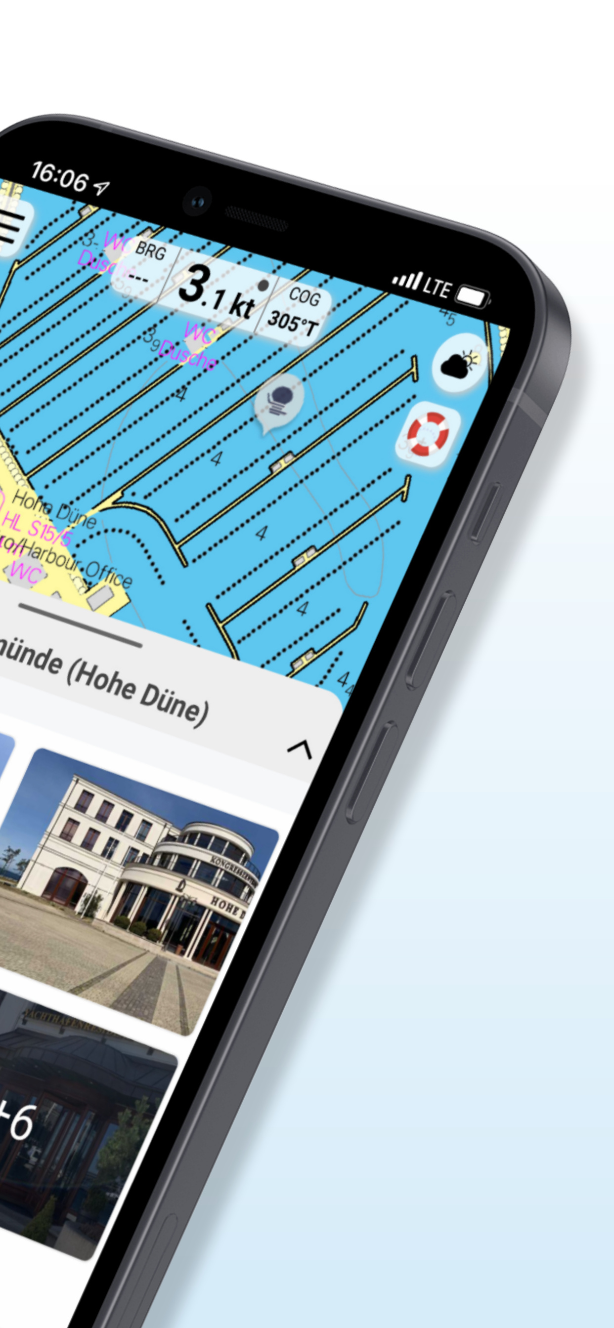
Easy to use paper and electronic charts, with good detail in most areas

Good companion to paper charts

kshillyer on

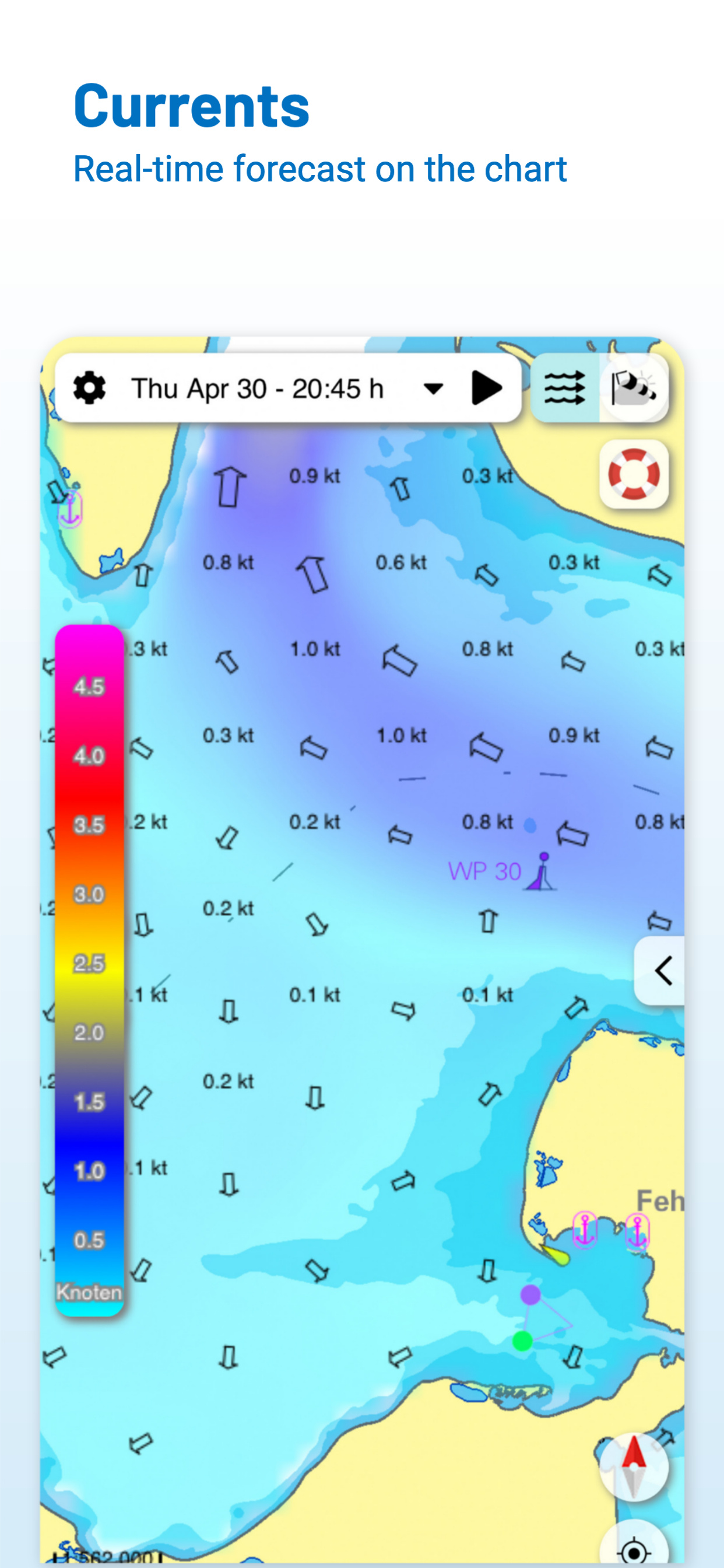
I like the wind forecast overlay, very useful.

Store Rankings

Ranking History

App Ranking History not available yet

Category Rankings

Chart
Category
Rank
Top Grossing
20
Top Grossing
25
Top Grossing
35
Top Grossing
41
Top Grossing
42

Keywords

Users may also like

Name
Waterkaarten: Boat Navigation
Routeplanner, AIS & Waterways
NavShip - Waterway Routing
Your waterway route assistant
Water Map Live - Holland
Routing, Sailing, Meteo, AIS
Aqua Map Boating
Marine navigation and fishing
Anchor Alarm / Watch
The anchor watch for your boat
WinGPS Marine
mySea
Yacht Navigator|Kartenplotter
Plotter für Sportbootkarten
Open Sea OpenSeaMap Browser
ADAC Skipper
Marina-Suche für Skipper
Show More

Revenue and Downloads

Gain valuable insights into NV Charts GPS Navigation AIS performance with our analytics. Sign up now to access downloads, revenue, and more.

App Info

Category
Navigation
Languages
German
Recent version
2.744.232 (3 weeks ago )
Released on
Jun 17, 2013 (11 years ago )
Last updated
16 hours ago