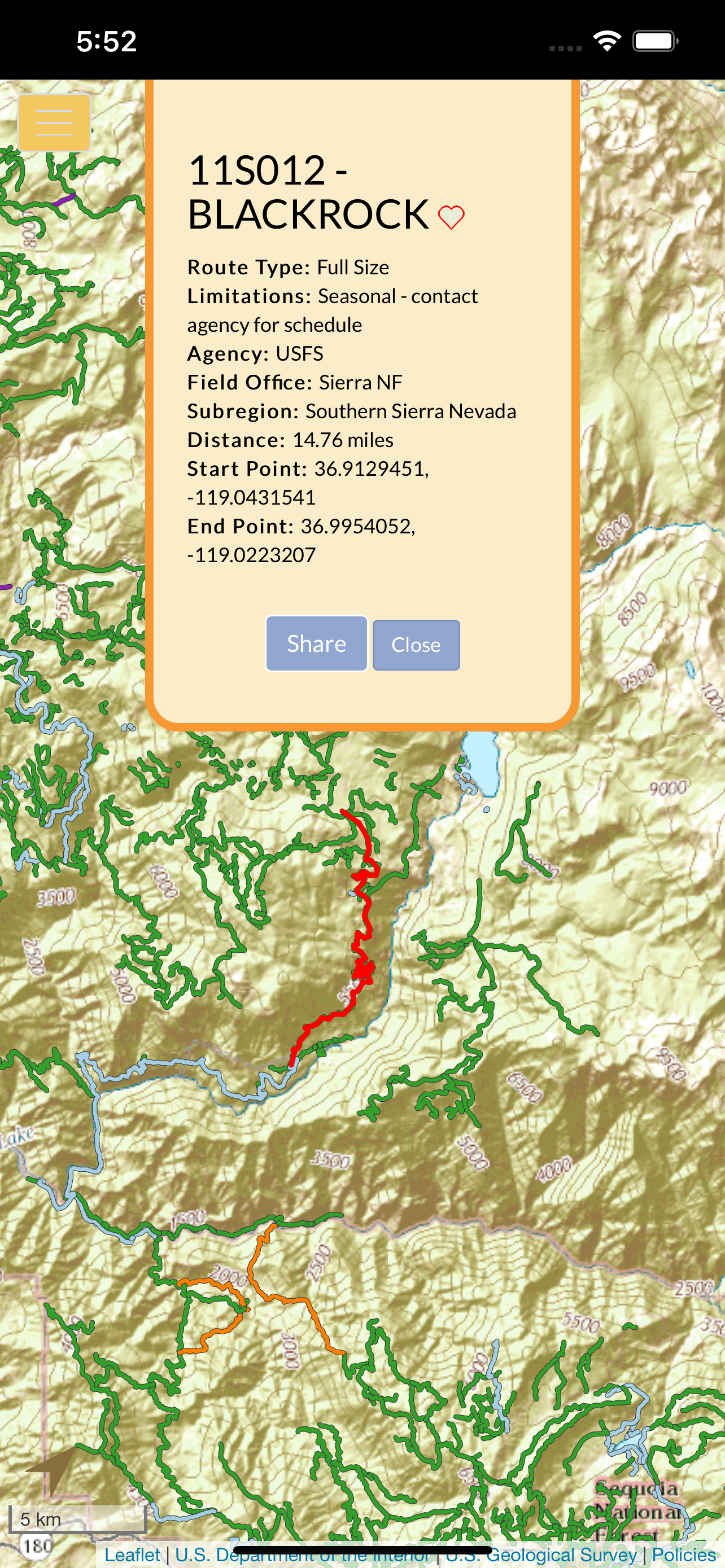
The OwlsheadGPS OHV Trails app depicts the designated OHV route networks of participating pubic land management agencies in California. We’ve acquired their official OHV route data and combined them into a mobile app that is designed for you -- the outdoor enthusiast. Remember, when you navigate California's backcountry dirt roads and trails using your motor vehicle, you must only drive on the routes that are officially designated and signed open for motorized use. Other OHV apps feature route data supplied by users and non-agency sources and may depict routes that are not actually legal for motorized use.
The OwlsheadGPS app includes more than 37,000 OHV and other motorized routes across lands managed by the Bureau of Land Management, US Forest Service, National Park Service, California Department of State Parks and Recreation, and other agencies throughout the State of California.
The OwlsheadGPS app allows you to:
√ Download trails and maps for any or all of seven regions to explore new and exciting areas outside the range of wifi and cell service,
√ Zoom and scroll across the map,
√ Display and update your location (iPhones and cellular iPads only),
√ View your location on the map whether moving or stationary,
√ Record and view saved tracks with My Rides,
√ Like and share with Favorite Trails,
√ Manage the display of data layers for wilderness, national monuments, military lands, park lands and other special status areas.
Please note that in order to use the OwlsheadGPS app offline, you will need to download large amounts of data. The first region that you download will contain data that pertains to all regions. Additional data sets will be smaller and take less time to download. The downloading of trail and map data for offline use is most successful across very fast internet connections, and when your device is awake and the OwlsheadGPS app is open. You will see a confirmation alert message when a data set has been successfully downloaded and is ready to use offline. If you do not receive this confirmation alert, please try your download again.
Location Services must be on to display and update your location on the map, or to record your tracks.
Hide..Show more..
Screenshots
User Rating
2.54 out of 5
13 ratings
in United States
5 star
4
4 star
1
3 star
0
2 star
1
1 star
7
Ratings History
Reviews
Maps never complete downloading
Iphone se 2nd gen. App downloaded fast but the maps didn’t. Tried to to download one map. Left the app open and phone awake/unlocked for over 5 hours and the it never finished some parts went to 100% but others never past 53% or 25%.
Can’t remove this abomination quickly enough
Great idea, truly awful implementation.
Doesn’t scroll vertically, and in spite of the app’s name, doesn’t seem to make use of the GPS.
Great database
It took me a while to download the offline maps. During that time I did not experience any kind of delays or hangups. As the app states at the beginning of the map download, the initial time is lengthy due to it downloading 80% of the data. After that it is much quicker. For me, the first time took about an hour, but I used most of my data allotment from HughesNet which is a satellite isp. My second down load took 15 min.
I hope that the program update will receive satellite imaging.
How to download
Had the download stop like others have said. Cancelled it, turned off cellular data and restarted download and it worked fine. As they say, it takes at least 30 minutes for the first download, then the rest are faster. Very cool app and even better that it's free. Thank you to the dev.
Doesn’t work
I really wanted this to work because it would be great to have offline maps of OHV trails but it doesn’t. It starts to download but never finishes. I know it’s not my internet speed because I have pretty fast internet.
Doesn’t work -
Never completes any downloads,even after deleting and re-loading the program.
Glad it’s free, ‘cause it’s worthless!
Deleting again…
Giving it one star, since you can’t give zeros.
Doesn't work
I would love to use this app but it doesn't download the maps offline. All it does is hang no matter how long i leave it on.
Doesn’t work
Have tried for months to get this to work .. I can not get it to download and off line maps ... it will start to download and then never finishes
Would really love to love this app since the idea is great