
Description
With Rivercast™ you get:
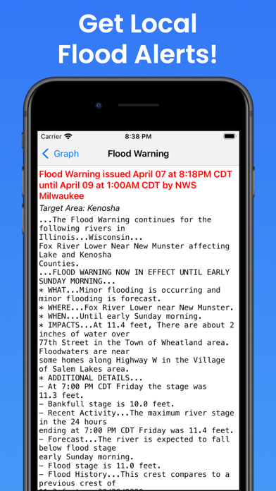
• Official Flood Warnings & other alerts from the National Weather Service
• River stage height in Feet
• River flow rate in CFS (when available)
• Indications that a river is at or approaching flood stage
• Current observations and recent history
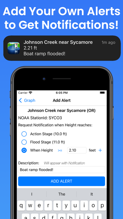
• Custom Push Notification Alerts for when river reaches levels of concern to you
• NOAA river forecasts (when available)
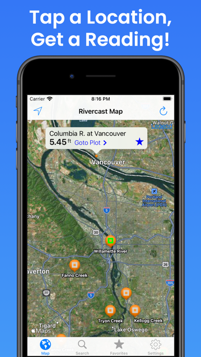
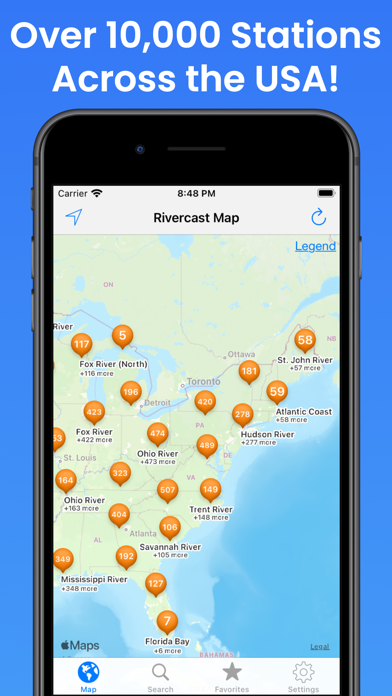
• Map interface that shows where river gauges are located geographically
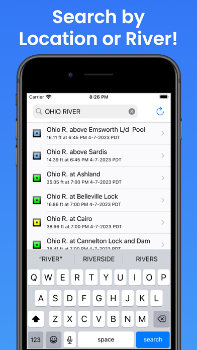
• Search interface to find river gauges by waterway name, state, or NOAA 5 digit station ID
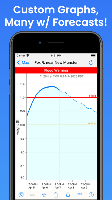
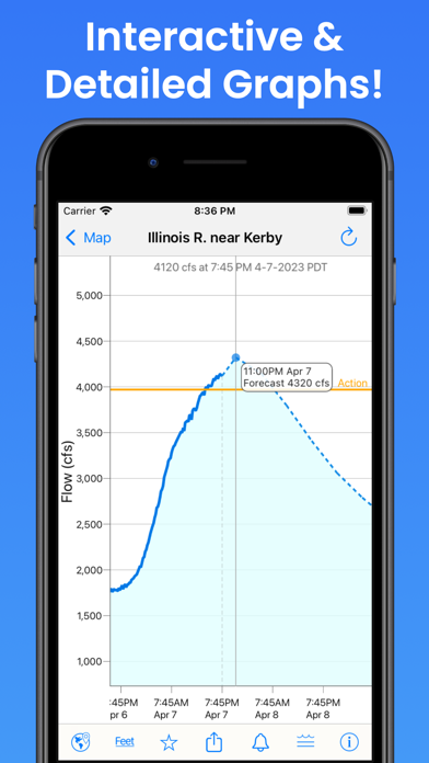
• Interactive graphs that you can zoom in, zoom out, or pan
• Customize your graphs by adding river levels that are relevant to you
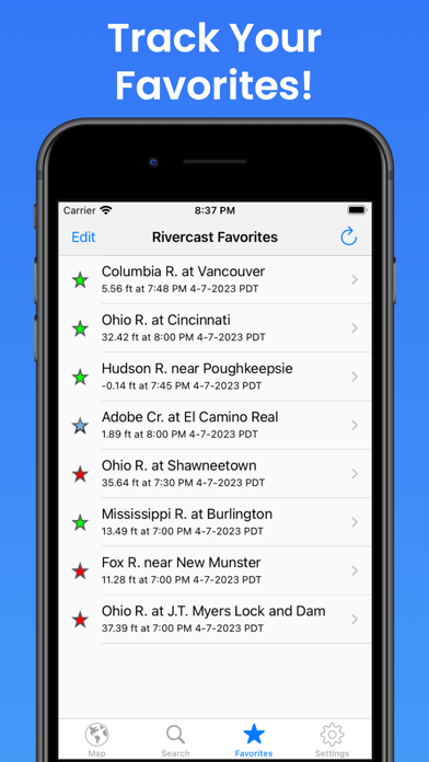
• Favorites list for locations you care about the most
• Share your graphs via iMessage, Email, Facebook, or Twitter
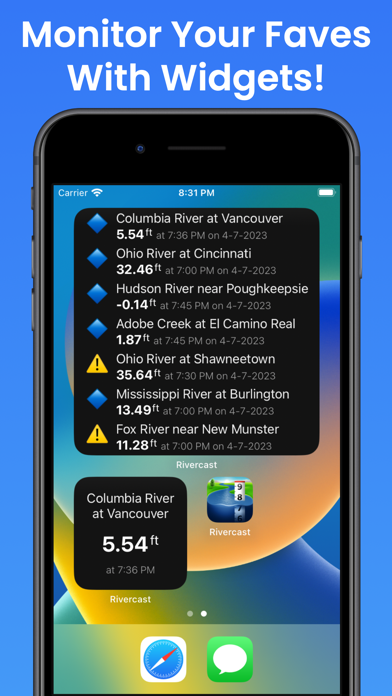
• Home Screen and Desktop Widgets to monitor your favorites
• Lock Screen & StandBy Mode Widgets to monitor your favorites
Rivercast's map not only shows you where the stations are, but color codes them when it can to give you an indication whether the location is at normal levels, approaching flood levels, or above flood stage.
You can get the latest observations from the map, search, or favorites. With an additional tap of your finger you can get a detailed interactive hydrograph. You can zoom in, zoom out, or pan with your fingers to find the exact information you need. If you "tap and hold" on the graph you can view the crosshair "bubble" text to assist you further.
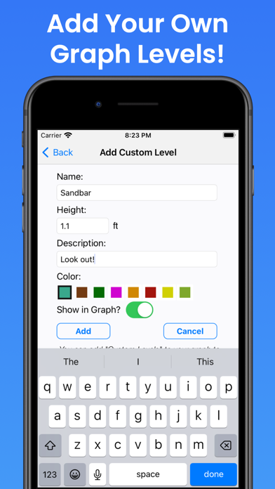
To customize your graphs for what's important to you, you can add your own level lines to mark things like sandbars, rocks, bridges, safe conditions, or whatever you would like.
And you can add the streams or rivers that you would like to regularly monitor to your Favorites list for easy "at a glance" viewing.
Rivercast™ uses the latest observation and forecast data available, and requires an Internet connection for use.
Favorites, Map "Instant Observations", Widget, and Hydrograph data is viewable in feet or cfs (when available).
All observation and forecast data is in your local time for your convenience.
A handy tool for boaters, fishermen, property owners, paddlers, scientists, marine professionals, and the curious.
River gauges reported are USA only.
* * * * * * * * * * * * * * * * * * * * * * *
Some Frequently Asked Questions:
Where does Rivercast™ get its data?
• This app uses NOAA sources for its raw data for our custom graphing and mapping solutions. There are some locations that are available via other government agencies (including USGS) that are not available via this app.
Why does Rivercast™ sometimes show slightly different flow data (CFS) than USGS?
• CFS is a calculated estimate derived from stage height. NOAA and USGS estimates may sometimes slightly vary due to using different data models. Variances are usually within a few percent, but can sometimes be larger. Stage height should always be identical between USGS and NOAA. Designated flood stages are based on stage height in feet in the USA.
Why does Rivercast™ only show observations, but not forecasts, for my river?
• NOAA issues forecasts for many, but not all, rivers it monitors. Sometimes forecasts are only issued seasonally, or during times of flooding or high water.
My river gauge was there yesterday, but its gone today?
• River gauges have a hard life. They occasionally have technical problems transmitting their data, or can even get washed out during extreme flooding. And some are seasonal. NOAA is usually pretty good about fixing them in a few days.
For more information about Rivercast™, please visit our website at www.RivercastApp.com!
We take our accuracy seriously!
Terms of Use: https://www.apple.com/legal/internet-services/itunes/dev/stdeula/
In-Apps
- Rivercast Premium Plus
- $8.99
Screenshots
Rivercast FAQ
-
Is Rivercast free?
Yes, Rivercast is free to download, however it contains in-app purchases or subscription offerings.
-
Is Rivercast legit?
Not enough reviews to make a reliable assessment. The app needs more user feedback.
Thanks for the vote -
How much does Rivercast cost?
Rivercast has several in-app purchases/subscriptions, the average in-app price is $8.99.
-
What is Rivercast revenue?
To get estimated revenue of Rivercast app and other AppStore insights you can sign up to AppTail Mobile Analytics Platform.

4.69 out of 5
9,338 ratings in United States
Rivercast Reviews
Store Rankings
|
Chart
|
Category
|
Rank
|
|---|---|---|
|
Top Free
|
|
138
|
|
Top Free
|

|
361
|
Keywords
Rivercast Competitors
| Name | Downloads (30d) | Monthly Revenue | Reviews | Ratings | Recent release | |
|---|---|---|---|---|---|---|

Solunar Best Hunting Times
Feeding and Hunt Time Calendar
|
Unlock
|
Unlock
|
20
|
|
2 months ago | |

Tide Alert (NOAA) - Tide Chart
NOAA Ocean tide table & charts
|
Unlock
|
Unlock
|
0
|
|
1 month ago | |

NOAA Marine Weather
Wind, swell and wave forecast
|
Unlock
|
Unlock
|
0
|
|
3 months ago | |

Buoycast: Marine Weather
NOAA Forecast, Wind, Tides
|
Unlock
|
Unlock
|
0
|
|
2 months ago | |

DeerCast-Prep, Predict, Pursue
Forecast movement. Map. Track.
|
Unlock
|
Unlock
|
20
|
|
2 weeks ago | |

RiverApp - River levels
Real-time river conditions
|
Unlock
|
Unlock
|
20
|
|
3 months ago | |

River Levels & Flows
USGS River Levels & Flows
|
Unlock
|
Unlock
|
20
|
|
7 months ago | |

FloodWatch
Monitor US river conditions
|
Unlock
|
Unlock
|
0
|
|
3 months ago | |

rivers.run
|
Unlock
|
Unlock
|
0
|
|
2 months ago | |

River Reports
Real-time river flows
|
Unlock
|
Unlock
|
0
|
|
1 year ago |
Rivercast Installs
Last 30 days
Rivercast Revenue
Last 30 daysRivercast Revenue and Downloads
Sign up now to access downloads, revenue, and more.
App Info
- Category
- Weather
- Publisher
-
Juggernaut Technology
- Languages
- English
- Recent release
- 5.13 (1 month ago )
- Released on
- Nov 17, 2012 (12 years ago )
- Also available in
- United States , Canada , Mexico , Australia , Czechia , Germany , France , United Kingdom , Italy , Malaysia , Philippines , Poland , Russia , Türkiye
- Last Updated
- 2 weeks ago