rivers.run
River info at your fingertips
#1 Keyword Rankings
Today
Top 10 Rankings
Today
Top 30 Rankings
Today
Top 100 Rankings
Today

Description

Rivers.run provides water levels, water temperature, and other information, using data collected from over 12,000 gauges. It matches this information with crowdsourced paddling expertise to tell you what a river height actually means, and to provide skill level estimates.

You can use GPS coordinates to find rivers near you, and search rivers by water levels, skill, name, and rating, as well as user provided tags and dam releases, helping you find whitewater (or flatwater) rivers that you want to paddle.

You can also use rivers.run maps to find rivers in an area, and to assist with navigation. Clicking on any point shows all the information rivers.run has about the river - flow, temperature, and other information. If you're interested in weather, you can also enable the weather view to get a good idea of where rain is currently falling.

River flow levels are currently sourced from USGS (United States Geological Survey), NWS (National Weather Service), and the Meterological Service of Canada. Additional sources for gauges are planned for the future.

Information on rivers.run is crowdsourced - so if your favorite river is not available, is missing information on runnable levels, or has other issues, you can help improve it. Just go to the FAQ page in app to find directions on how to get started. If you need any assistance, you can send an email to [email protected].

NOTE: Rivers.run does work offline, however needs to connect at least once in order to download river information. Attempting to use rivers.run offline before it has downloaded information may result in a launch screen freeze. The data being downloaded is ~1MB in size, and highly compressed.
Hide.. Show more..

Screenshots

User Rating

5 out of 5

11 ratings in United States

5 star
11
4 star
0
3 star
0
2 star
0
1 star
0

Ratings History

Reviews

Rivers.run

WOR Actual on

This app is exactly what white water paddlers have been looking for. Fantastic compilation of data sources. Carefully built, beautifully displayed. A keeper.

This might be the best whitewater river app

Smithandwesson21 on

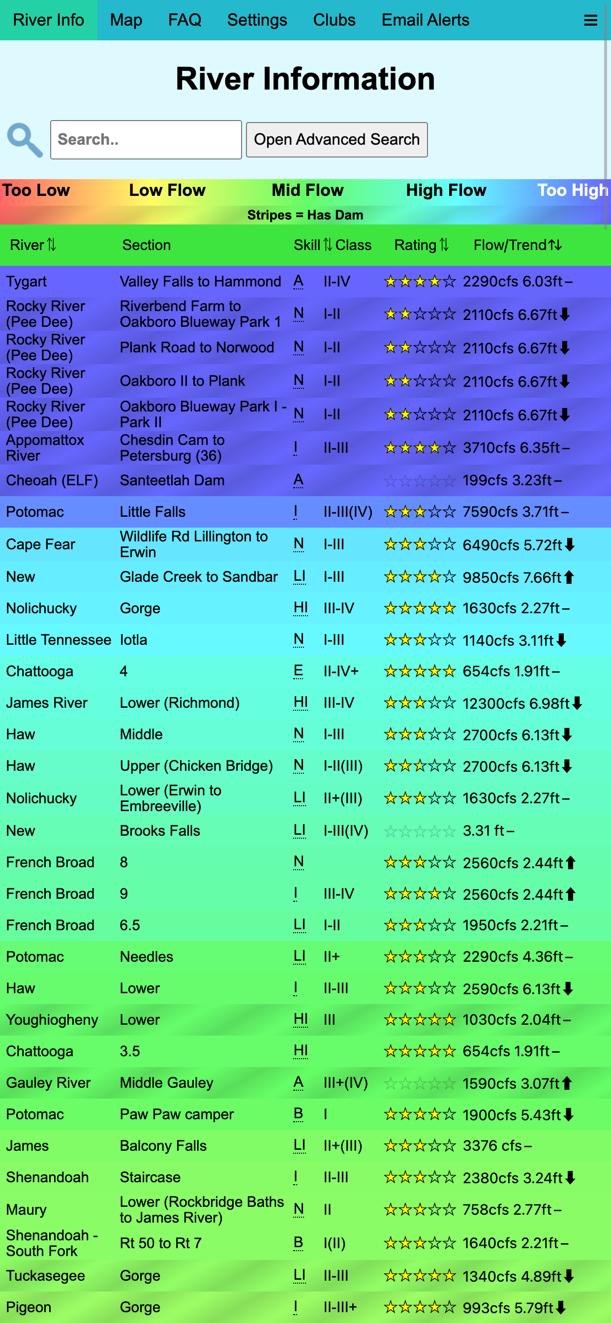
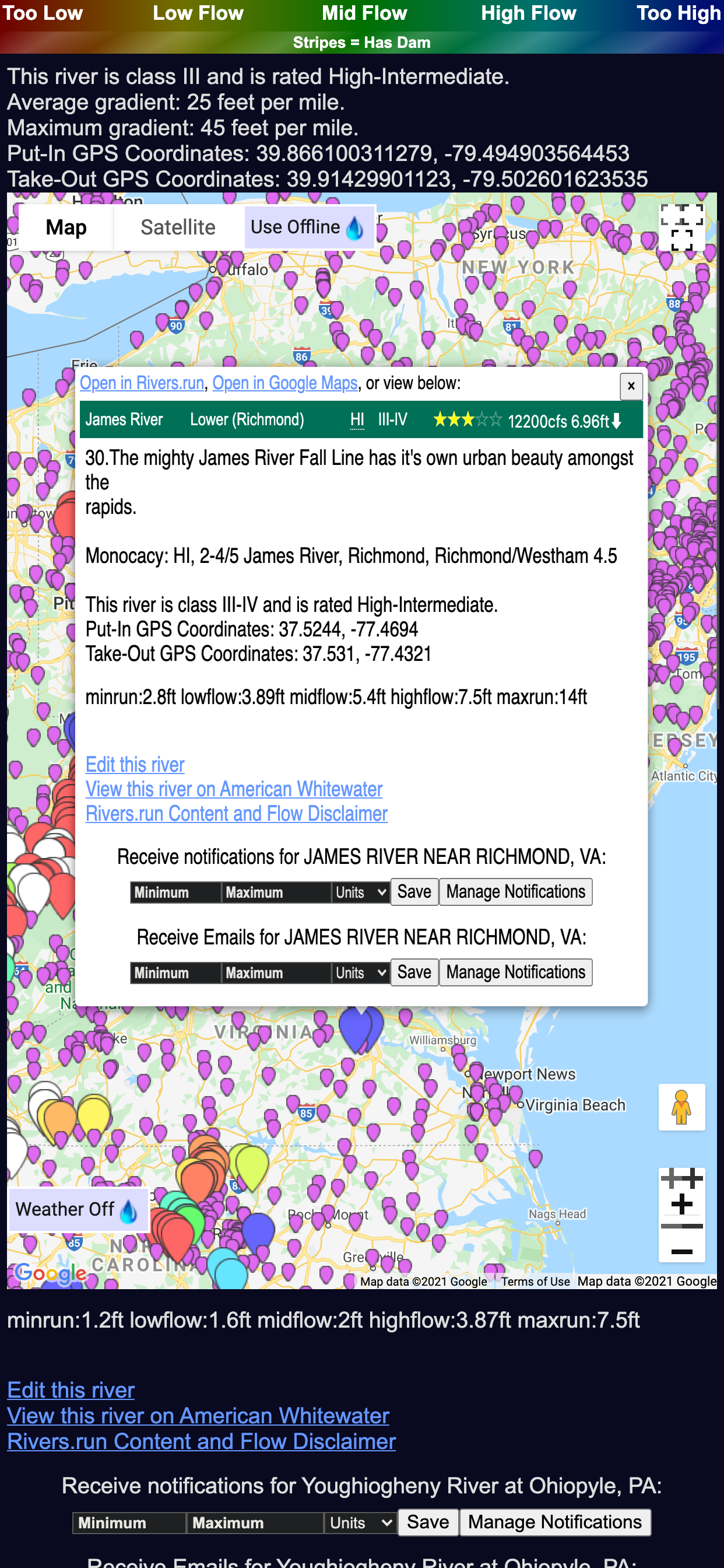
This app is specifically written for whitewater rivers. It includes a map with a pin for every river gage in US and Canada. Whatever you want in a whitewater river app, it probably already exists in this app. And there is a link for each river for you to submit suggestions to the developer.

Rivers.run

Having fun now! on

Amazing resource for paddlers! It has everything you would want and things you did not think of - River levels, gauges, gps coordinates, directions and maps to put in and take out, searches of your favorites you can share with friends. Very intuitive and user friendly. This will be so helpful as I branch out to new rivers in my area and across the country.

Store Rankings

Ranking History

Category Rankings

Chart
Category
Rank
Top Free
180

Keywords

Users may also like

Name
Rivercast - Levels & Forecasts
USA River Levels and Forecasts
Solunar Best Fishing Times
Fish Hunting Calendar
RiverApp - River levels
Real-time river conditions
River Levels & Flows
USGS River Levels & Flows
FloodWatch
Monitor US river conditions
Epicenter - Global Earthquakes
Worldwide USGS & EMSC Data
River Reports
Real-time river flows
River Data
Best app for USGS river data!
Riffle: River Levels & Weather
River Levels & Weather
Blue Liner Flows
USGS River Flow Information
Show More

Revenue and Downloads

Gain valuable insights into rivers.run performance with our analytics. Sign up now to access downloads, revenue, and more.

App Info

Category
Weather
Publisher
Tucker Willenborg
Languages
English
Recent version
2.0 (2 years ago )
Released on
Feb 11, 2021 (3 years ago )
Last updated
1 month ago