
Valleseco Hiking Trails
#1 Keyword Rankings
Today
Top 10 Rankings
Today
Top 30 Rankings
Today
Top 100 Rankings
Today
Description
The municipality of Valleseco is located in the interior and northern area of the island of Gran Canaria, just 7 kms from Teror. Despite its name (dry valley), it is a humid area which formed part of the large extension of laurel forest that used to occupy the whole of the inner region. One of the characteristics of the municipality is its lush vegetation. In fact, 80 % of its territory is a Protected Region. Visitors have a wide range of tracks to see its most beautiful spots.
You can use this application and its maps without any connection to internet to walk through the Network of Paths of Valleseco.
Continued use of GPS running in the background can dramatically decrease battery life.
Hide..
Show more..
You can use this application and its maps without any connection to internet to walk through the Network of Paths of Valleseco.
Continued use of GPS running in the background can dramatically decrease battery life.
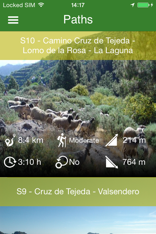
Screenshots

 User Rating
0 out of 5
0 ratings in United States
Ratings History
Reviews
App doesn't have any reviews yet
Store Rankings
Ranking History
App Ranking History not available yet
Category Rankings
App is not ranked yet
Keywords
Users may also like
| Name | Reviews | Recent release | |
|---|---|---|---|

WalkMe | Walking in Madeira
#1 Walking app of Madeira!
|
9
|
2 weeks ago | |

bergfex: hiking & tracking
Tour planner & GPS navigation
|
7
|
1 week ago | |

OpenMaps - Topographic maps
Open source topographic maps
|
7
|
3 weeks ago | |

WeGoTrip Audio Tours & Guide
City & Museum Travel Planner
|
18
|
4 days ago | |

Hika - Hiking trails and maps
Hike and walk with GPS routes
|
1
|
1 month ago | |

GuaguasGLOBAL
|
0
|
9 months ago | |

Caminos Naturales
|
0
|
4 months ago | |

La Cueva de Valporquero
|
0
|
2 years ago | |

Camino Santiago entre volcanes
Camino de Santiago Canarias
|
0
|
1 year ago | |

Summit, Hiking Log Peakhunter
Logbook with Topo Maps
|
22
|
1 year ago |
Show More
Revenue and Downloads
Gain valuable insights into Senderos de Valleseco performance with our analytics. Sign up now
to
access downloads, revenue, and more.
App Info
- Category
- Travel
- Publisher
- Aboratec S.C.P
- Languages
- Spanish, German, English
- Recent version
- 1.0.6 (8 years ago )
- Released on
- Feb 2, 2016 (8 years ago )
- Also available in
- Spain, Pakistan, Italy, Japan, South Korea, Kuwait, Kazakhstan, Lebanon, Mexico, Malaysia, Nigeria, Netherlands, New Zealand, Peru, Philippines, India, Poland, Portugal, Romania, Russia, Saudi Arabia, Sweden, Singapore, Thailand, Turkey, Taiwan, Ukraine, United States, Vietnam, South Africa, Denmark, Argentina, Australia, Azerbaijan, Belgium, Brazil, Belarus, Canada, Switzerland, Chile, China, Colombia, Czechia, Germany, United Arab Emirates, Dominican Republic, Algeria, Ecuador, Egypt, Finland, United Kingdom, Greece, Hong Kong, Hungary, Indonesia, Ireland, Israel, Norway, France, Austria
- Last updated
- 1 month ago