
Description
Modo oscuro exclusivo.
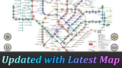
El sistema MRT de Singapur se está extendiendo. Para 2030, el sistema MRT será más complejo de lo que te imaginas. Es bueno para todos los residentes de nuestra encantadora isla. Pero también será un problema porque no sabemos cómo viajar más rápido cuando cambiamos de estación.
Singapore MRT Map Route está diseñado para permitir a los usuarios obtener la mejor ruta en un segundo. Te ayudará a ahorrar mucho tiempo a lo largo de los años.
- Ver el último mapa MRT de Singapur
- Mostrar la mejor ruta entre dos estaciones
- Calcular automáticamente el tiempo de viaje estimado
- No requiere conexión a internet.
Actualizado al último sistema MRT:
Downtown Line(Azul)
Bukit Panjang, Cashew, Hillview, Beauty World, King Albert Park, Sixth Avenue, Tan Kah Kee, Botanic Gardens, Stevens, Newton, Little India, Rochor, Bugis, Promenade, Bayfront, Downtown, Telok Ayer, Chinatown
Circle Line(Amarillo)
Dhoby Ghaut, Bras Basah, Esplanade, Promenade, Nicoll Highway[C], Stadium, Mountbatten, Dakota, Paya Lebar, MacPherson, Tai Seng, Bartley, Serangoon, Lorong Chuan, Bishan, Marymount, Caldecott, Botanic Gardens, Farrer Road, Holland Village. Buona Vista, one-north, Kent Ridge, Haw Par Villa, Pasir Panjang, Labrador Park, Telok Blangah, HarbourFront
East West Line (Verde)
Pasir Ris, Tampines, Simei, Tanah Merah, Bedok, Kembangan, Eunos, Paya Lebar, Aljunied, Kallang, Lavender, Bugis, City Hall, Raffles Place, Tanjong Pagar, Outram Park, Tiong Bahru, Redhill, Queenstown, Commonwealth, Buona Vista, Dover, Clementi, Jurong East, Chinese Garden, Lakeside, Boon Lay, Pioneer, Joo Koon, Expo,
Changi Airport
North South Line (Rojo)
Jurong East, Bukit Batok, Bukit Gombak, Choa Chu Kang, Yew Tee, Kranji, Marsiling, Woodlands, Admiralty, Sembawang, Canberra, Yishun, Khatib, Yio Chu Kang, Ang Mo Kio, Bishan, Braddell, Toa Payoh, Novena, Newton, Orchard, Somerset, Dhoby Ghaut, City Hall, Raffles Place, Marina Bay, Marina South Pier
North East Line (Púrpura)
HarbourFront, Outram Park, Chinatown, Clarke Quay, Dhoby Ghaut, Little India, Farrer Park, Boon Keng, Potong Pasir, Woodleigh, Serangoon, Kovan, Hougang, Buangkok, Sengkang, Punggol
Screenshots


Singapore MRT Map Route(Pro) FAQ
-
Is Singapore MRT Map Route(Pro) free?
Singapore MRT Map Route(Pro) is not free (it costs 2.99), however it doesn't contain in-app purchases or subscriptions.
-
Is Singapore MRT Map Route(Pro) legit?
Not enough reviews to make a reliable assessment. The app needs more user feedback.
Thanks for the vote -
How much does Singapore MRT Map Route(Pro) cost?
The price of Singapore MRT Map Route(Pro) is 2.99.
-
What is Singapore MRT Map Route(Pro) revenue?
To get estimated revenue of Singapore MRT Map Route(Pro) app and other AppStore insights you can sign up to AppTail Mobile Analytics Platform.

3 out of 5
2 ratings in Canada
Singapore MRT Map Route(Pro) Reviews
Store Rankings
|
Chart
|
Category
|
Rank
|
|---|---|---|
|
Top Paid
|

|
1
|
|
Top Paid
|
|
4
|
|
Top Paid
|

|
23
|
|
Top Paid
|

|
24
|
|
Top Grossing
|
|
28
|
Singapore MRT Map Route(Pro) Competitors
| Name | Downloads (30d) | Monthly Revenue | Reviews | Ratings | Recent release | |
|---|---|---|---|---|---|---|

SG-BUS (Real Time)
|
Unlock
|
Unlock
|
0
|
|
2 years ago | |

Singapore Train Route Planner
|
Unlock
|
Unlock
|
0
|
|
1 year ago | |

Hong Kong Taxi Cards
Translate address in Chinese
|
Unlock
|
Unlock
|
0
|
|
1 year ago | |

BEIDO MAP-Satellite Streetview
Satellite maps and street view
|
Unlock
|
Unlock
|
0
|
|
1 year ago | |

Changi Airport (SIN) + Radar
|
Unlock
|
Unlock
|
0
|
|
3 years ago | |

Jakarta Airport (CGK) + Radar
CGK Live Arrivals/Departures
|
Unlock
|
Unlock
|
0
|
|
3 years ago | |

Train Island
Live Activities for SG MRT
|
Unlock
|
Unlock
|
0
|
|
3 days ago | |

Sakura Navi - Forecast in 2024
Cherry Blossom spots in Japan
|
Unlock
|
Unlock
|
0
|
|
10 months ago | |

Next Station
Navigate the MRT better
|
Unlock
|
Unlock
|
0
|
|
2 months ago | |

Speech Translator: Be Heard
Speak And Understand Anywhere
|
Unlock
|
Unlock
|
0
|
|
8 months ago |
Singapore MRT Map Route(Pro) Installs
Last 30 days
Singapore MRT Map Route(Pro) Revenue
Last 30 daysSingapore MRT Map Route(Pro) Revenue and Downloads
Sign up now to access downloads, revenue, and more.
App Info
- Category
- Navigation
- Publisher
- Wan Peng
- Languages
- English
- Recent release
- 2.5.1 (6 months ago )
- Released on
- Nov 2, 2011 (13 years ago )
- Also available in
- Singapore , Indonesia , United States , Vietnam , United Kingdom , Taiwan , Japan , Malaysia , Netherlands , China , Norway , South Korea , Canada , Egypt , South Africa , France , Greece , Hong Kong SAR China , India , Belgium , Germany , Brazil , Thailand , Italy , Romania , Nigeria , Ukraine , Türkiye , Nepal , Tunisia , New Zealand , Peru , Philippines , Slovenia , Sweden , Saudi Arabia , Pakistan , Poland , Russia , Portugal , Dominican Republic , Argentina , Austria , Australia , Azerbaijan , Bulgaria , Brunei , Belarus , Switzerland , Chile , Colombia , Czechia , Denmark , Mexico , Algeria , Ecuador , Spain , Finland , Hungary , Ireland , Israel , United Arab Emirates , Kuwait , Kazakhstan , Lebanon , North Macedonia
- Last Updated
- 1 week ago