Singapore MRT Map Route(Pro)

Subway, Metro Transport

Published by: Wan Peng

Description

Updated Thomson-East Coast Line (TE1 Woodlands North to Gardens by the Bay) to the subway system.
Exclusive Dark Mode.
Singapore's MRT system is extending. By 2030, the MRT system will be more complex than you could image. It's good for all residents on our lovely island. But also will be a problem because we don't know how to travel the fastest when transfering stations.
Singapore MRT Map Route is designed to allows user to get the best route within a second. It will help you save a lot of time over years.
- View lastest Singapore MRT map
- Display the best route between two stations
- Automatically calculate estimated travel time
- Require no internet connection.
Updated to latest MRT system:
Downtown Line(Blue)
Bukit Panjang, Cashew, Hillview, Beauty World, King Albert Park, Sixth Avenue, Tan Kah Kee, Botanic Gardens, Stevens, Newton, Little India, Rochor, Bugis, Promenade, Bayfront, Downtown, Telok Ayer, Chinatown
Circle Line(Yellow)
Dhoby Ghaut, Bras Basah, Esplanade, Promenade, Nicoll Highway[C], Stadium, Mountbatten, Dakota, Paya Lebar, MacPherson, Tai Seng, Bartley, Serangoon, Lorong Chuan, Bishan, Marymount, Caldecott, Botanic Gardens, Farrer Road, Holland Village. Buona Vista, one-north, Kent Ridge, Haw Par Villa, Pasir Panjang, Labrador Park, Telok Blangah, HarbourFront
East West Line (Green)
Pasir Ris ,Tampines , Simei , Tanah Merah , Bedok , Kembangan , Eunos , Paya Lebar , Aljunied , Kallang , Lavender , Bugis , City Hall , Raffles Place , Tanjong Pagar , Outram Park , Tiong Bahru , Redhill , Queenstown , Commonwealth , Buona Vista , Dover ,Clementi , Jurong East , Chinese Garden , Lakeside , Boon Lay , Pioneer , Joo Koon, Expo,
Changi Airport
North South Line (Red)
Jurong East, Bukit Batok, Bukit Gombak, Choa Chu Kang, Yew Tee, Kranji, Marsiling, Woodlands, Admiralty, Sembawang, Canberra, Yishun, Khatib, Yio Chu Kang, Ang Mo Kio, Bishan, Braddell, Toa Payoh, Novena, Newton, Orchard, Somerset, Dhoby Ghaut, City Hall, Raffles Place, Marina Bay, Marina South Pier
North East Line (Purple)
HarbourFront, Outram Park, Chinatown, Clarke Quay, Dhoby Ghaut, Little India, Farrer Park, Boon Keng, Potong Pasir, Woodleigh, Serangoon, Kovan, Hougang, Buangkok, Sengkang, Punggol
Hide Show More...

Screenshots

Singapore MRT Map Route(Pro) FAQ

  • Is Singapore MRT Map Route(Pro) free?

    Yes, Singapore MRT Map Route(Pro) is completely free and it doesn't have any in-app purchases or subscriptions.

  • Is Singapore MRT Map Route(Pro) legit?

    🤔 The Singapore MRT Map Route(Pro) app's quality is mixed. Some users are satisfied, while others report issues. Consider reading individual reviews for more context.

    Thanks for the vote

  • How much does Singapore MRT Map Route(Pro) cost?

    Singapore MRT Map Route(Pro) is free.

  • What is Singapore MRT Map Route(Pro) revenue?

    To get estimated revenue of Singapore MRT Map Route(Pro) app and other AppStore insights you can sign up to AppTail Mobile Analytics Platform.

User Rating

4 out of 5

1 ratings in Egypt

5 star
0
4 star
1
3 star
0
2 star
0
1 star
0
Ratings History

Singapore MRT Map Route(Pro) Reviews

Need further improvement

Bhdlee on

Singapore

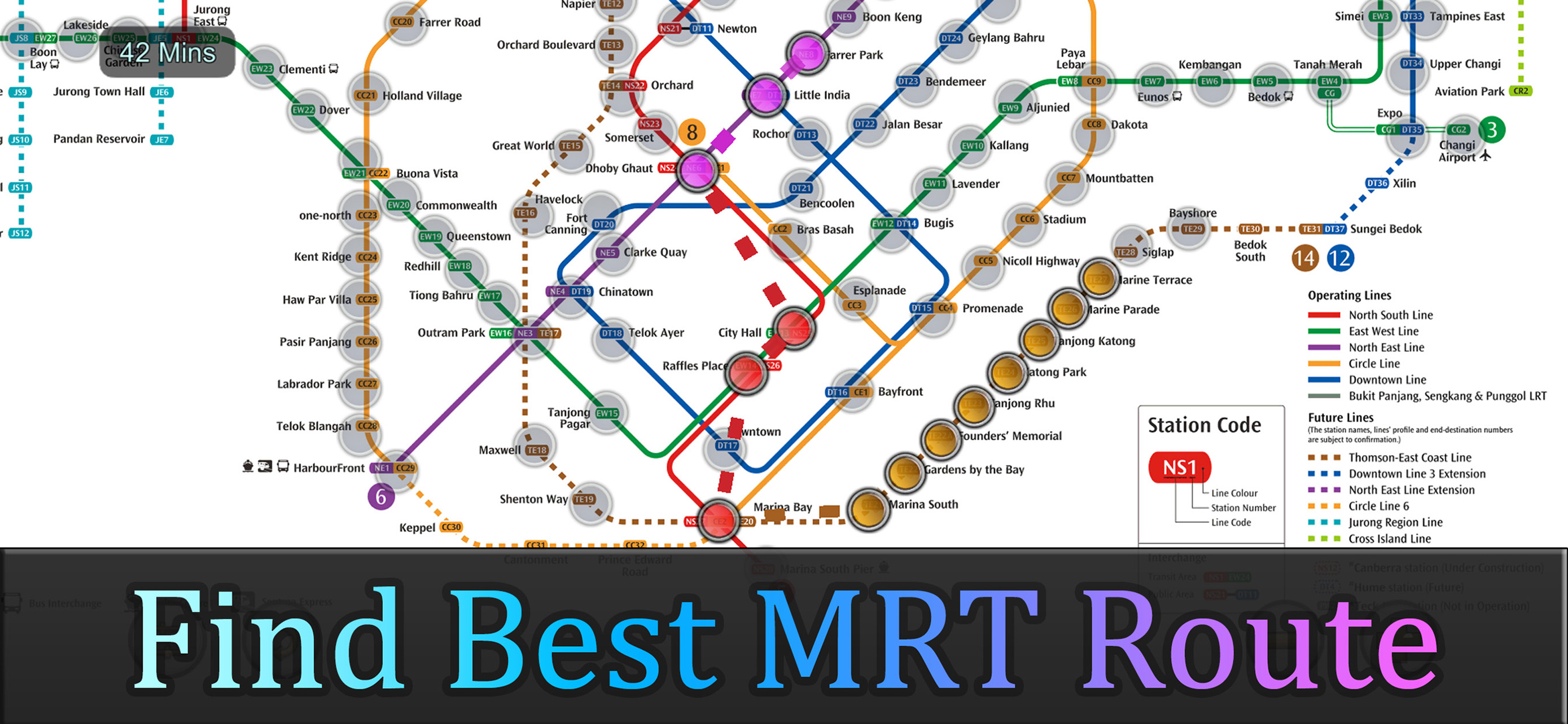
So far, the IU platform is very interactive. One thing that can be improved further is that you could add in more MRT routes from Point A to Point B. For now, it doesn’t have this such.

Excellent App

Nepz777 on

Singapore

Need To Update Latest Map And Stations

Executive

sunamitakoyaki on

Singapore

Excellent

Superb

Wanisrafsgp on

Singapore

Best, gave me the best route to which mrt i want to go. I would suggest if you able to show us the estimate the first and last train for each station that will be super helpful. Other than that its a great app!

Requires update for new lines

Bappa82B on

Singapore

Good design, please update the new lines

Good for mrt commute

Gotten jester on

Singapore

I have paid pro version but i hope the developers the rating box. It keep showing everytime I launch it.

Timing between Interchange

Joshua-300T on

Singapore

I have noticed that timing on the estimated arrival timing will be totally be far from the arrival timing specially if a person done crossing between few interchanges….Hope that there is also an additional estimated walking timing within those station at least timing of estimated arrival time will not be far from the actual arrival time or else the purpose of the Your apps will be defeated specially these issue will applies for those time conscious people who are rushing to work soecially in the morning

Excellent

Stanlrythsoh on

Singapore

Very useful love it

MRT PRO

Kelim28 on

Singapore

Ok

Not intuitive

Upset Resident on

Singapore

Lousy app. Not intuitive to allow different routes to reach same destination for more choices. Too fixated. Needs alot of improvement. If the app is not flexible we don’t need this at all coz no difference from checking the 2D print map. Also, the timing is not accurate and did not include LRTs as well. The future lines are running but still stated as ‘future’. I want my money back…

Store Rankings

Ranking History
App Ranking History not available yet
Category Rankings
Chart
Category
Rank
Top Paid
1
Top Paid
4
Top Paid
6
Top Paid
11
Top Grossing
16

Singapore MRT Map Route(Pro) Competitors

Singapore MRT Map Route(Pro) Installs

Last 30 days

Singapore MRT Map Route(Pro) Revenue

Last 30 days

Singapore MRT Map Route(Pro) Revenue and Downloads

Gain valuable insights into Singapore MRT Map Route(Pro) performance with our analytics.
Sign up now to access downloads, revenue, and more.
This page includes copyrighted content from third parties, shared solely for commentary and research in accordance with fair use under applicable copyright laws. All trademarks, including product, service, and company names or logos, remain the property of their respective owners. Their use here falls under nominative fair use as outlined by trademark laws and does not suggest any affiliation with or endorsement by the trademark holders.