
SityTrail
Hiking Trail GPS Offline Maps
#1 Keyword Rankings
Today
Top 10 Rankings
Today
Top 30 Rankings
Today
Top 100 Rankings
Today
Description
GO AND DISCOVER ALL THE PATHS AROUND THE WORLD FOR FREE
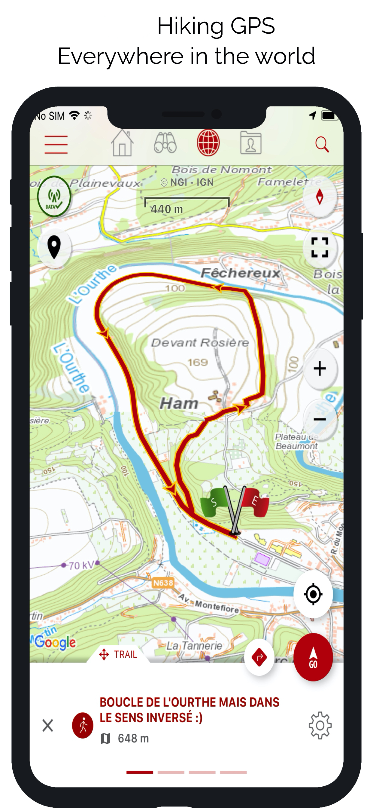
• Record your trails while taking HD and geo-tagged pictures of your adventures.
• Travelled distance, Km-effort, average speed, calories burned, etc.
• Accurate altimeter, height differences computing and elevation profile displaying your current location.
• Alarm when you go off the path of the trail being followed. No more need to backtrack!
• Automatic triggering of points of interest with text-to-speech.
• Create a free account and all your data will be available everywhere on every device.
• With our online editor, create your own trails using a Web browser on your PC/Mac and then access them directly from your iPhone to experience them on the ground.
• Sort and classify your trails and points of interest in your own lists.
GO FURTHER AND BECOME A PREMIUM USER!
• Download world topographic maps for offline use.
• Add topographic maps of your choice, from IGN France, IGN / NGI Belgium, IGN Spain, swisstopo, Austria, USA (USGS topographic mapping), Canada (Toporama).
• Discover GR hiking paths, European hiking routes, Santiago de Compostela routes for pilgrims, etc.
• You can also discover all cycling networks: Greenway network in France, Ravel in Belgium, European cycling routes, knot points networks in Flanders and the Netherlands.
• And in winter, discover all the ski slopes with their names.
• Access the public catalogue of trails from SityTrail members and communities.
• Advanced tracking and guiding features with calculation of the remaining distance and time and vocal instructions at intersections.
• Go further and transform your favourite trails into real multimedia guides with text, photos, video links, and share them with the SityTrail community.
• Create your own hiker communities and manage your members and newsfeeds.
• Create trails with our advanced features for trail editing via our website.
• Print trails in PDF format with QR codes. (A4, A3).
• Access geotagged Wikipedia articles from our SityTrip module.
HEALTH KIT INTEGRATION
The application is now compatible with Health Kit : you can add your activity (trail following or recording) to the "Health" app.
AVAILABLE ON APPLE WATCH
Find all the features of SityTrail app on your Apple Watch: follow a trail, record a trail, map, voice guidance, vibrations, alarm when you go off the path, elevation profile, compass, etc.
IMPORTANT INFORMATION
• Some features need an internet connection.
• The prolonged use of GPS can reduce battery levels.
• Our privacy policy is available here: https://connect.geolives.com/j8w7fb0dxb6oqm677674/privacy_policy.html
• Our terms of use are available here: https://www.sitytrail.com/en/wiki/?page=help&content=Terms_Of_Use
INFORMATION FOR IN-APP PURCHASES
• Payment will be charged to your iTunes Account on confirmation of purchase.
• Subscription automatically renews unless auto-renew is turned off at least 24-hours before the end of the current period.
• Your account will be charged for renewal within 24-hours of the end of the current period. The cost of the renewal will be the same as the cost of your initial transaction.
• You can manage your subscriptions and auto-renewal may be turned off by going to your Account Settings after purchase.
Hide..
Show more..
• Record your trails while taking HD and geo-tagged pictures of your adventures.
• Travelled distance, Km-effort, average speed, calories burned, etc.
• Accurate altimeter, height differences computing and elevation profile displaying your current location.
• Alarm when you go off the path of the trail being followed. No more need to backtrack!
• Automatic triggering of points of interest with text-to-speech.
• Create a free account and all your data will be available everywhere on every device.
• With our online editor, create your own trails using a Web browser on your PC/Mac and then access them directly from your iPhone to experience them on the ground.
• Sort and classify your trails and points of interest in your own lists.
GO FURTHER AND BECOME A PREMIUM USER!
• Download world topographic maps for offline use.
• Add topographic maps of your choice, from IGN France, IGN / NGI Belgium, IGN Spain, swisstopo, Austria, USA (USGS topographic mapping), Canada (Toporama).
• Discover GR hiking paths, European hiking routes, Santiago de Compostela routes for pilgrims, etc.
• You can also discover all cycling networks: Greenway network in France, Ravel in Belgium, European cycling routes, knot points networks in Flanders and the Netherlands.
• And in winter, discover all the ski slopes with their names.
• Access the public catalogue of trails from SityTrail members and communities.
• Advanced tracking and guiding features with calculation of the remaining distance and time and vocal instructions at intersections.
• Go further and transform your favourite trails into real multimedia guides with text, photos, video links, and share them with the SityTrail community.
• Create your own hiker communities and manage your members and newsfeeds.
• Create trails with our advanced features for trail editing via our website.
• Print trails in PDF format with QR codes. (A4, A3).
• Access geotagged Wikipedia articles from our SityTrip module.
HEALTH KIT INTEGRATION
The application is now compatible with Health Kit : you can add your activity (trail following or recording) to the "Health" app.
AVAILABLE ON APPLE WATCH
Find all the features of SityTrail app on your Apple Watch: follow a trail, record a trail, map, voice guidance, vibrations, alarm when you go off the path, elevation profile, compass, etc.
IMPORTANT INFORMATION
• Some features need an internet connection.
• The prolonged use of GPS can reduce battery levels.
• Our privacy policy is available here: https://connect.geolives.com/j8w7fb0dxb6oqm677674/privacy_policy.html
• Our terms of use are available here: https://www.sitytrail.com/en/wiki/?page=help&content=Terms_Of_Use
INFORMATION FOR IN-APP PURCHASES
• Payment will be charged to your iTunes Account on confirmation of purchase.
• Subscription automatically renews unless auto-renew is turned off at least 24-hours before the end of the current period.
• Your account will be charged for renewal within 24-hours of the end of the current period. The cost of the renewal will be the same as the cost of your initial transaction.
• You can manage your subscriptions and auto-renewal may be turned off by going to your Account Settings after purchase.
In-Apps
- Premium Czech Republic
- ¥168.00
- SityTrail Premium Japan
- ¥168.00
- SityTrail Premium Norway
- ¥148.00
- SityTrail Premium Croatia
- ¥168.00
- SityTrail Premium Denmark
- ¥168.00
- SityTrail Premium Estonia
- ¥168.00
- SityTrail Premium Germany
- ¥143.00
- SityTrail Premium Slovakia
- ¥168.00
- SityTrail Premium Slovenia
- ¥168.00
- SityTrail Premium New Zealand
- ¥168.00
Screenshots


 User Rating
0 out of 5
0 ratings in China
Ratings History
Reviews
App doesn't have any reviews yet
Store Rankings
Ranking History
App Ranking History not available yet
Category Rankings
|
Chart
|
Category
|
Rank
|
|---|---|---|
|
Top Grossing
|

|
6
|
|
Top Grossing
|

|
16
|
|
Top Free
|
|
319
|
Keywords
Users may also like
| Name | Reviews | Recent release | |
|---|---|---|---|

Iphigénie | The Hiking Map App
IGN maps, hiking, outdoor
|
0
|
1 month ago | |
OutDoors GPS France - IGN Maps
Plan Hiking & Biking Routes
|
0
|
10 months ago | |
Visorando Walking Routes
Outdoor GPS working offline
|
0
|
17 hours ago | |

IGNrando' – France hiking maps
Hiking & cycling with IGN maps
|
0
|
4 days ago | |

GPX viewer
The paper map reinvented
|
0
|
10 months ago | |

Hika - Hiking trails and maps
Hike and walk with GPS routes
|
0
|
1 month ago | |

Wandelknooppunt
Our map, your path
|
0
|
8 months ago | |

Cirkwi
|
0
|
1 year ago | |
Cartes IGN
Découvrez la France autrement
|
0
|
3 weeks ago | |

MaRando – FFRandonnée
Sentiers, promenades, GR, GPS
|
0
|
2 months ago |
Show More
Revenue and Downloads
Gain valuable insights into SityTrail performance with our analytics. Sign up now
to
access downloads, revenue, and more.
App Info
- Category
- Travel
- Publisher
- Geolives Belgium S.P.R.L.
- Languages
- Dutch, German, English, French, Italian, Spanish
- Recent version
- 12.14.7 (2 weeks ago )
- Released on
- Mar 21, 2011 (13 years ago )
- Also available in
- France, Belgium, Netherlands, Switzerland, United Kingdom, United States, Germany, India, Canada, Japan, Italy, Israel, Sweden, Brazil, Portugal, Nigeria, Malaysia, Norway, New Zealand, Peru, Mexico, Lebanon, Philippines, Pakistan, Poland, South Africa, Romania, Russia, Saudi Arabia, Singapore, Thailand, Turkey, Taiwan, Ukraine, Vietnam, United Arab Emirates, Algeria, Argentina, Austria, Australia, Azerbaijan, Belarus, Chile, China, Colombia, Czechia, Denmark, Dominican Republic, Kazakhstan, Ecuador, Egypt, Spain, Finland, Greece, Hong Kong, Hungary, Indonesia, Ireland, South Korea, Kuwait
- Last updated
- 2 weeks ago