
GPX viewer
The paper map reinvented
#1 Keyword Rankings
Today
Top 10 Rankings
Today
Top 30 Rankings
Today
Top 100 Rankings
Today
Description
Import your routes in GPX format (tracks or routes) into the application.
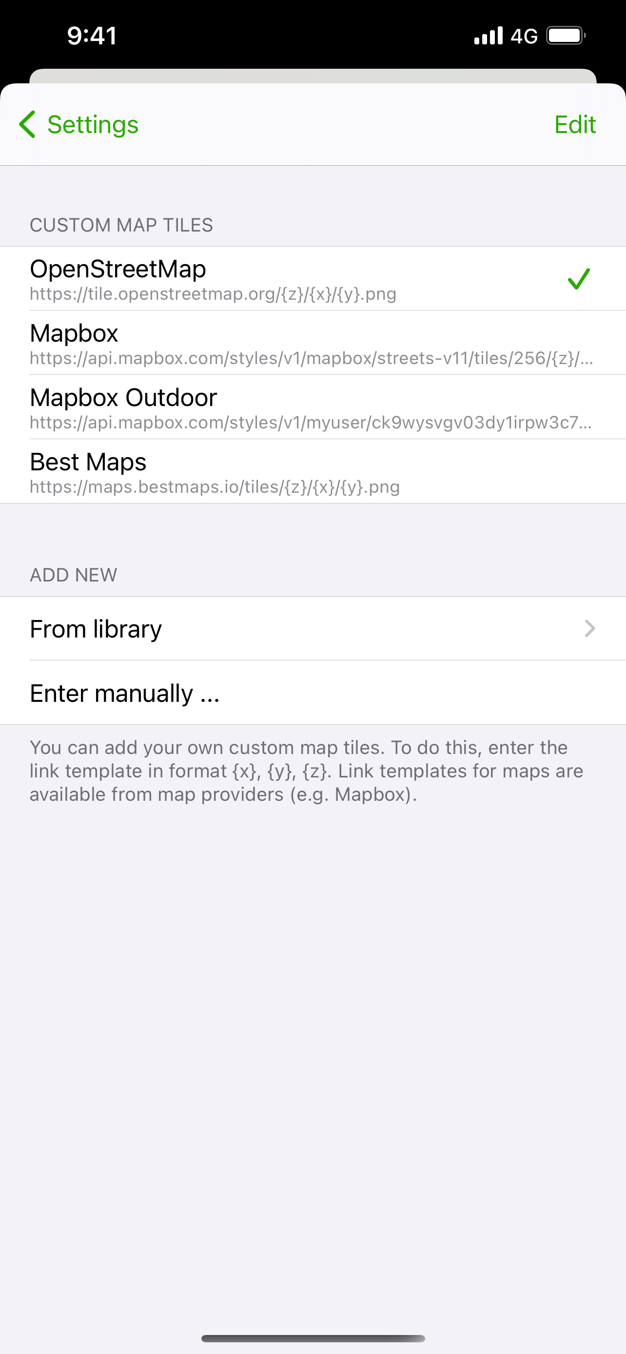
Display them on different preset maps (plan, satellite, OpenStreetMap, OpenTopoMap, Swisstopo, IGN) or on your own custom maps.
Display an elevation graph to evaluate their difficulty. And check out all of their information.
Follow your position along the route during your ride. You can also display points of interest from GPX.
All what you need to go hiking and follow your route. All for free and without ads. The only in-app purchases are tips for few other features, take a look.
Features details:
- Import of GPX files via file or web link
- Management of imported GPX (library)
- Display GPX track on the map (track and route)
- Several base maps: map, hybrid, satellite 3D, OpenStreetMap, OpenTopoMap, Swisstopo
- Possibility to set your own custom maps from a library or manually
- Possibility to download maps for offline use
- Displayed on the map: current position, start and end of the route, points of interest along the route, scale, route direction
- Choice of color and size of the route
- Locking of screen standby to better follow the route
- Map cache system
- Display of GPX details: name, description, longitudinal profile, elevation differences, distance, image gallery, link, points of interest
- Display details of a point of interest: name, description, image gallery, links
- Access to the route via Maps, Google Maps or Waze
- Sharing a GPX
- GPX editor
- Speedometer
Note: If the application cannot open a GPX file, contact me by sending me the file.
Hide..
Show more..
Display them on different preset maps (plan, satellite, OpenStreetMap, OpenTopoMap, Swisstopo, IGN) or on your own custom maps.
Display an elevation graph to evaluate their difficulty. And check out all of their information.
Follow your position along the route during your ride. You can also display points of interest from GPX.
All what you need to go hiking and follow your route. All for free and without ads. The only in-app purchases are tips for few other features, take a look.
Features details:
- Import of GPX files via file or web link
- Management of imported GPX (library)
- Display GPX track on the map (track and route)
- Several base maps: map, hybrid, satellite 3D, OpenStreetMap, OpenTopoMap, Swisstopo
- Possibility to set your own custom maps from a library or manually
- Possibility to download maps for offline use
- Displayed on the map: current position, start and end of the route, points of interest along the route, scale, route direction
- Choice of color and size of the route
- Locking of screen standby to better follow the route
- Map cache system
- Display of GPX details: name, description, longitudinal profile, elevation differences, distance, image gallery, link, points of interest
- Display details of a point of interest: name, description, image gallery, links
- Access to the route via Maps, Google Maps or Waze
- Sharing a GPX
- GPX editor
- Speedometer
Note: If the application cannot open a GPX file, contact me by sending me the file.
In-Apps
- A burger
- ¥58.00
- A coffee
- ¥28.00
- Hiking equipment
- ¥148.00
Screenshots


 User Rating
0 out of 5
0 ratings in China
Ratings History
Reviews
App doesn't have any reviews yet
Store Rankings
Ranking History
App Ranking History not available yet
Category Rankings
|
Chart
|
Category
|
Rank
|
|---|---|---|
|
Top Free
|

|
22
|
|
Top Free
|

|
44
|
|
Top Free
|

|
44
|
|
Top Grossing
|

|
49
|
|
Top Grossing
|
|
51
|
Keywords
Users may also like
| Name | Reviews | Recent release | |
|---|---|---|---|

Iphigénie | The Hiking Map App
IGN maps, hiking, outdoor
|
0
|
1 month ago | |

GPS Tracks
GPS Tracker and Offline Maps
|
8
|
1 week ago | |

Wikiloc户外导航仪
一个探索的世界
|
12
|
2 weeks ago | |

Topo GPS - Topographic maps
Plan and follow gpx routes
|
1
|
6 days ago | |

Routiq, Outdoor routes
Find, Create & Navigate routes
|
0
|
2 months ago | |

OsmAnd Maps Travel & Navigate
Offline maps for travel
|
8
|
1 month ago | |

Visorando Walking Routes
Outdoor GPS working offline
|
0
|
2 days ago | |

Open GPX Tracker
No ads, no in-app purchases
|
3
|
1 year ago | |

IGNrando' – France hiking maps
Hiking & cycling with IGN maps
|
0
|
2 months ago | |

Fietsknoop bike and hiking app
Use all bike and hike nodes
|
0
|
1 month ago |
Show More
Revenue and Downloads
Gain valuable insights into GPX viewer performance with our analytics. Sign up now
to
access downloads, revenue, and more.
App Info
- Category
- Navigation
- Publisher
- Jonathan Gander
- Languages
- English, French
- Recent version
- 1.3.10 (9 months ago )
- Released on
- May 6, 2020 (4 years ago )
- Also available in
- France, Germany, Netherlands, Switzerland, Belgium, Russia, United Kingdom, Italy, Spain, United States, Hungary, Australia, Brazil, Sweden, Mexico, Poland, Austria, Portugal, Ukraine, Canada, Vietnam, Israel, Indonesia, India, Thailand, Turkey, South Africa, Argentina, Finland, Denmark, Egypt, Pakistan, Peru, Algeria, Dominican Republic, Romania, Saudi Arabia, Czechia, Singapore, Colombia, China, Taiwan, Chile, Belarus, Azerbaijan, Philippines, Hong Kong, New Zealand, Norway, Ecuador, Nigeria, Malaysia, Lebanon, Kazakhstan, Kuwait, South Korea, Japan, United Arab Emirates, Greece, Ireland
- Last updated
- 2 weeks ago