Description
衛星から土地、道路、公園、国、湖などを測定します。 距離、エリア、および周長を計算します。
このアプリケーションは、多くの競合他社がしないことを提供する機能:
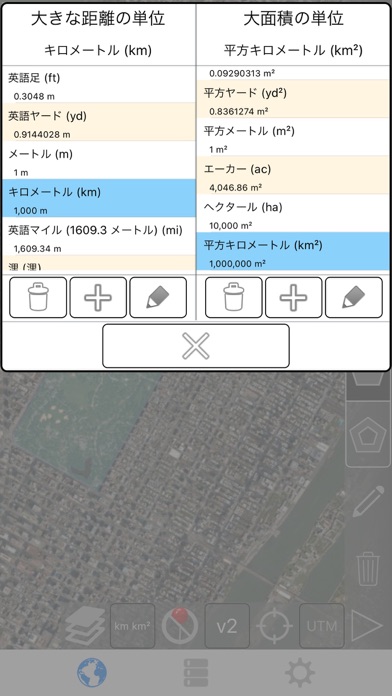
- カスタムの距離と面積の単位を追加します。
- 内部多角形を描画します。 たとえば、土地面積を削除水の体を持つ。
- パスの中間にポイントを追加 (のみのパスの末尾に追加することができます)、パスの末尾に追加するをタップ。 長いパスの中間に追加するキーを押します。
- パスまたはポリゴンの 2 つのポイントをスワップします。
- GPS 受信機から、現在の場所を追加します。
機能:
- 3 のマップ レイヤー オプション
- 輸出し、輸入の Dropbox、iCloud、電子メールなどを介して .kml ファイル
- ピンはドラッグ可能で手動で編集可能です
- 名前、ノート、および色の各パスとポリゴンのフィールド
- 電子メールやテキスト メッセージのパスとポリゴン データ
- 4 つの冗長モード。 見たい情報だけを参照してください。
- 郵便番号、市、住所などで検索します。
- 取得アドレス マップ上の近点
4 描画モード:
- パス
- ポリゴン
- 中空スペース内部でポリゴン
- (誤って編集しないように)-編集モード
パスに表示される値:
- 総距離
- 各ウェイ ポイント増分距離
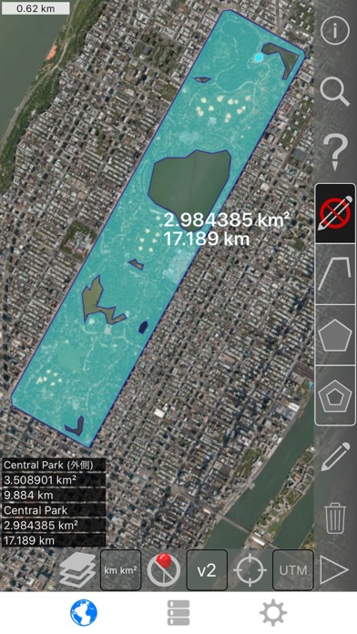
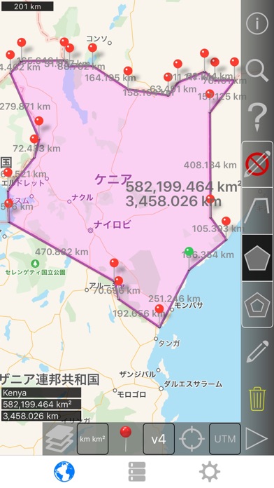
多角形の表示される値:
- 地域
- 境界
- 各側面のための距離
パスまたは 4 つの方法の 1 のポリゴンにポイントを追加します。
- 地図上をタップします。
- ● 現在の場所を使用します。
- 座標を手動で入力します。
- インポート .kml ファイル
既定の距離単位を含めます。
- メートル
- フィート
- ヤード
- キロ
- マイル
- 海里
デフォルトの面積単位を含めます。
- 平方メートル
- 平方フィート
- 平方ヤード
- 平方キロメートル
- 平方マイル
- 正方形の海里
- 正方形のエーカー
- 平方ヘクタール
座標の形式。
- 度
- 度、分
- 度、分、秒表示
- UTM / UPS (ユニバーサル横メルカトル) / (ユニバーサル極ステレオグラフィック)
- MGRS (ミリタリーグリッドリファレンスシステム)
English:
Measure land, roads, parks, countries, lakes, etc from a satellite view. Calculates distances, areas, and perimeters.
Features that this application offers that most competitors do not:
- Add custom distance and area units.
- Draw interior polygons. For example, land area with bodies of water removed.
- Add a point to the middle of a path (Most only allow you to add to the end of the path) Tap to add to the end of a path. Long press to add to the middle of a path.
- Swap two points in a path or polygon.
- Add your current location from GPS receiver.
Features:
- 3 map layer options
- Export and import .kml files via Dropbox, iCloud, email, etc
- Pins are draggable and manually editable
- Name, notes, and color fields for each path and polygon
- Email or text message path and polygon data
- 4 verbosity modes. See only the information that you want to see
- Search by postal code, city, address, etc
- Get addresses near point on map
4 drawing modes:
- Path
- Polygon
- Polygon with hollow spaces inside
- No edit mode (to prevent accidental edits)
Values displayed for paths:
- Total distance
- Incremental distance for each waypoint
Values displayed for polygons:
- Area
- Perimeter
- Distance for each side
Add points to a path or polygon in 1 of 4 ways:
- Tap on the map
- Use current location
- Enter coordinates manually
- Import .kml file
Default distance units include:
- Meter
- Foot
- Yard
- Kilometer
- Mile
- Nautical mile
Default area units include:
- Square meter
- Square foot
- Square yard
- Square kilometer
- Square mile
- Square nautical mile
- Square acre
- Square hectare
Coordinate formats:
- Degrees
- Degrees, minutes
- Degrees, minutes, seconds
- UTM / UPS (Universal Transverse Mercator) / (Universal Polar Stereographic)
- MGRS (Military Grid Reference System)
Hide
Show More...
このアプリケーションは、多くの競合他社がしないことを提供する機能:
- カスタムの距離と面積の単位を追加します。
- 内部多角形を描画します。 たとえば、土地面積を削除水の体を持つ。
- パスの中間にポイントを追加 (のみのパスの末尾に追加することができます)、パスの末尾に追加するをタップ。 長いパスの中間に追加するキーを押します。
- パスまたはポリゴンの 2 つのポイントをスワップします。
- GPS 受信機から、現在の場所を追加します。
機能:
- 3 のマップ レイヤー オプション
- 輸出し、輸入の Dropbox、iCloud、電子メールなどを介して .kml ファイル
- ピンはドラッグ可能で手動で編集可能です
- 名前、ノート、および色の各パスとポリゴンのフィールド
- 電子メールやテキスト メッセージのパスとポリゴン データ
- 4 つの冗長モード。 見たい情報だけを参照してください。
- 郵便番号、市、住所などで検索します。
- 取得アドレス マップ上の近点
4 描画モード:
- パス
- ポリゴン
- 中空スペース内部でポリゴン
- (誤って編集しないように)-編集モード
パスに表示される値:
- 総距離
- 各ウェイ ポイント増分距離
多角形の表示される値:
- 地域
- 境界
- 各側面のための距離
パスまたは 4 つの方法の 1 のポリゴンにポイントを追加します。
- 地図上をタップします。
- ● 現在の場所を使用します。
- 座標を手動で入力します。
- インポート .kml ファイル
既定の距離単位を含めます。
- メートル
- フィート
- ヤード
- キロ
- マイル
- 海里
デフォルトの面積単位を含めます。
- 平方メートル
- 平方フィート
- 平方ヤード
- 平方キロメートル
- 平方マイル
- 正方形の海里
- 正方形のエーカー
- 平方ヘクタール
座標の形式。
- 度
- 度、分
- 度、分、秒表示
- UTM / UPS (ユニバーサル横メルカトル) / (ユニバーサル極ステレオグラフィック)
- MGRS (ミリタリーグリッドリファレンスシステム)
English:
Measure land, roads, parks, countries, lakes, etc from a satellite view. Calculates distances, areas, and perimeters.
Features that this application offers that most competitors do not:
- Add custom distance and area units.
- Draw interior polygons. For example, land area with bodies of water removed.
- Add a point to the middle of a path (Most only allow you to add to the end of the path) Tap to add to the end of a path. Long press to add to the middle of a path.
- Swap two points in a path or polygon.
- Add your current location from GPS receiver.
Features:
- 3 map layer options
- Export and import .kml files via Dropbox, iCloud, email, etc
- Pins are draggable and manually editable
- Name, notes, and color fields for each path and polygon
- Email or text message path and polygon data
- 4 verbosity modes. See only the information that you want to see
- Search by postal code, city, address, etc
- Get addresses near point on map
4 drawing modes:
- Path
- Polygon
- Polygon with hollow spaces inside
- No edit mode (to prevent accidental edits)
Values displayed for paths:
- Total distance
- Incremental distance for each waypoint
Values displayed for polygons:
- Area
- Perimeter
- Distance for each side
Add points to a path or polygon in 1 of 4 ways:
- Tap on the map
- Use current location
- Enter coordinates manually
- Import .kml file
Default distance units include:
- Meter
- Foot
- Yard
- Kilometer
- Mile
- Nautical mile
Default area units include:
- Square meter
- Square foot
- Square yard
- Square kilometer
- Square mile
- Square nautical mile
- Square acre
- Square hectare
Coordinate formats:
- Degrees
- Degrees, minutes
- Degrees, minutes, seconds
- UTM / UPS (Universal Transverse Mercator) / (Universal Polar Stereographic)
- MGRS (Military Grid Reference System)
Screenshots

距離と面積の測定 FAQ
-
Is 距離と面積の測定 free?
距離と面積の測定 is not free (it costs 1300.00), however it doesn't contain in-app purchases or subscriptions.
-
Is 距離と面積の測定 legit?
Not enough reviews to make a reliable assessment. The app needs more user feedback.
Thanks for the vote -
How much does 距離と面積の測定 cost?
The price of 距離と面積の測定 is 1300.00.
-
What is 距離と面積の測定 revenue?
To get estimated revenue of 距離と面積の測定 app and other AppStore insights you can sign up to AppTail Mobile Analytics Platform.

User Rating
App is not rated in Japan yet.
Ratings History
距離と面積の測定 Reviews
Store Rankings
Ranking History
App Ranking History not available yet
Category Rankings
|
Chart
|
Category
|
Rank
|
|---|---|---|
|
Top Paid
|

|
60
|
|
Top Paid
|

|
70
|
|
Top Paid
|

|
75
|
|
Top Paid
|

|
85
|
|
Top Paid
|

|
98
|
Keywords
距離と面積の測定 Competitors
| Name | Downloads (30d) | Monthly Revenue | Reviews | Ratings | Recent release | |
|---|---|---|---|---|---|---|

面積計 地図上に GPS フィールド距離や面積を測定
地図上の面、距離、角度、周囲長、緯度、経度、土地測量
|
Unlock
|
Unlock
|
0
|
|
3 months ago | |

Gas-main
Gas pipeline calculation
|
Unlock
|
Unlock
|
0
|
|
1 year ago | |

PhytechPlanner
|
Unlock
|
Unlock
|
0
|
|
3 months ago | |

LidarCad
Professional Cad Solution
|
Unlock
|
Unlock
|
0
|
|
2 years ago | |

Phytech Frost
Phytech LTD
|
Unlock
|
Unlock
|
0
|
|
3 months ago | |

Construction+
Asphalt,Concrete,Drywall,Roofs
|
Unlock
|
Unlock
|
0
|
|
9 months ago | |

Bayes' calculator
Calculate Bayes Theorem
|
Unlock
|
Unlock
|
0
|
|
1 year ago | |
topoArea
|
Unlock
|
Unlock
|
0
|
|
3 years ago | |

iMapIt Pro
Measure lands with GPS
|
Unlock
|
Unlock
|
0
|
|
3 years ago | |

Structural Engineering Calc.
58 engineering calculators
|
Unlock
|
Unlock
|
0
|
|
2 days ago |
Távolság és területmérés Installs
Last 30 days
Távolság és területmérés Revenue
Last 30 days距離と面積の測定 Revenue and Downloads
Gain valuable insights into Távolság és területmérés performance with our analytics.
Sign up now to access downloads, revenue, and more.
Sign up now to access downloads, revenue, and more.
App Info
- Category
- Productivity
- Publisher
-
TappiApps

- Languages
- Czech, Danish, Dutch, English, Finnish, French, German, Greek (modern), Hungarian, Indonesian, Italian, Japanese, Korean, Malay, Norwegian Bokmål, Polish, Portuguese, Romanian, Russian, Chinese, Slovak, Spanish, Swedish, Thai, Chinese, Turkish, Ukrainian, Vietnamese
- Recent release
- 2.6 (2 years ago )
- Released on
- Aug 4, 2015 (9 years ago )
- Also available in
- Hungary , Argentina , Ukraine , Thailand , Madagascar , Nepal , Norway , Netherlands , Nigeria , Malaysia , Mexico , Malta , North Macedonia , Peru , Latvia , Sri Lanka , Lebanon , Kazakhstan , Kuwait , South Korea , New Zealand , Italy , Philippines , Pakistan , Poland , Portugal , Romania , Russia , Saudi Arabia , Sweden , Singapore , Taiwan , United States , Uzbekistan , Vietnam , South Africa , Switzerland , Dominican Republic , Denmark , Germany , Czechia , Cyprus , Colombia , China , Chile , Algeria , Canada , Belarus , Belgium , Azerbaijan , Australia , Austria , Armenia , Japan , Ecuador , Egypt , Spain , Finland , France , United Kingdom , Greece , Hong Kong SAR China , Croatia , Indonesia , Ireland , Israel , India , Iceland , United Arab Emirates
- Last Updated
- 3 days ago
This page includes copyrighted content from third parties, shared solely for commentary and research in accordance with fair use under applicable copyright laws. All trademarks, including product, service, and company names or logos, remain the property of their respective owners. Their use here falls under nominative fair use as outlined by trademark laws and does not suggest any affiliation with or endorsement by the trademark holders.