
Odległość i pomiar powierzchni
Distance and Area Measure
#1 Keyword Rankings
Today
Top 10 Rankings
Today
Top 30 Rankings
Today
Top 100 Rankings
Today
Description
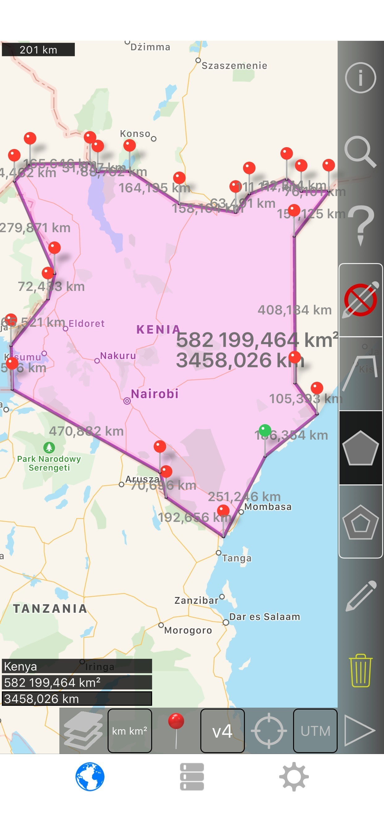
Mierz ziemię, drogi, parki, kraje, jeziora itp. Oblicza odległości, obszary i obwody.
Funkcje, które ta aplikacja oferuje, że większość konkurentów nie:
- Dodać niestandardowe jednostki odległości i powierzchni.
- Rysowanie wielokątów wnętrza. Na przykład obszar lądowy z wody usuwane.
- Dodać punkt na środku ścieżki (większość tylko umożliwiają dodawanie do końca ścieżki) Naciśnij, aby dodać na końcu ścieżki. Naciśnij długo, aby dodać w środku ścieżki.
- Zamienić dwa punkty w ścieżkę lub Wielokąt.
- Dodać bieżącą z odbiornika GPS.
Funkcje:
- 3 opcji warstwy mapy
- Eksport i import plików .kml za pośrednictwem Dropbox, iCloud, e-mail, itp
- Piny można przeciągać i edytować ręcznie
- Nazwa, zauważa, a kolor pola dla każdej ścieżki i Wielokąt
- Wysłał lub dane tekstowe wiadomości ścieżki i Wielokąt
- 4 tryby szczegółowości. Wyświetlić tylko te informacje, które chcesz zobaczyć
- Wyszukiwanie po kod pocztowy, miasto, adres, itp
- Get adresy w pobliżu point na mapie
4 tryby rysunek:
- Ścieżka
- Wielokąt
- Wielokąt z pustych miejsc wewnątrz
- Brak trybu edycji (aby zapobiec przypadkowej zmiany)
Wartości wyświetlane dla ścieżki:
- Całkowita odległość
- Odległość dla każdej trasy
Wartości wyświetlane dla wielokątów:
- Obszar
- Obwód
- Odległość dla każdej strony
Dodać punkty do ścieżkę lub Wielokąt w 1 4 sposoby:
- Dotknij na mapie
- Użyj bieżącej lokalizacji
- Ręcznie wprowadzić współrzędne
- Plik Importuj .kml
Domyślne jednostki odległości obejmują:
- Miernik
- Stopa
- Stoczni
- Kilometr
- Mile
- Mil
Domyślnymi jednostkami obszaru obejmują:
- Metrowy
- Metrową
- Jard kwadratowy
- Km²
- Square mile
- Square mile morskie
- Akr kwadrat
- Ha kwadrat
Formatów współrzędnych:
- Stopnie
- Stopnie, minuty
- Stopnie, minuty, sekundy
- UTM/UPS (uniwersalny Transverse Mercator)/(Universal Polar stereograficzny)
- MGRS (wojskowy system referencyjny siatki)
English:
Measure land, roads, parks, countries, lakes, etc from a satellite view. Calculates distances, areas, and perimeters.
Features that this application offers that most competitors do not:
- Add custom distance and area units.
- Draw interior polygons. For example, land area with bodies of water removed.
- Add a point to the middle of a path (Most only allow you to add to the end of the path) Tap to add to the end of a path. Long press to add to the middle of a path.
- Swap two points in a path or polygon.
- Add your current location from GPS receiver.
Features:
- 3 map layer options
- Export and import .kml files via Dropbox, iCloud, email, etc
- Pins are draggable and manually editable
- Name, notes, and color fields for each path and polygon
- Email or text message path and polygon data
- 4 verbosity modes. See only the information that you want to see
- Search by postal code, city, address, etc
- Get addresses near point on map
4 drawing modes:
- Path
- Polygon
- Polygon with hollow spaces inside
- No edit mode (to prevent accidental edits)
Values displayed for paths:
- Total distance
- Incremental distance for each waypoint
Values displayed for polygons:
- Area
- Perimeter
- Distance for each side
Add points to a path or polygon in 1 of 4 ways:
- Tap on the map
- Use current location
- Enter coordinates manually
- Import .kml file
Default distance units include:
- Meter
- Foot
- Yard
- Kilometer
- Mile
- Nautical mile
Default area units include:
- Square meter
- Square foot
- Square yard
- Square kilometer
- Square mile
- Square nautical mile
- Square acre
- Square hectare
Coordinate formats:
- Degrees
- Degrees, minutes
- Degrees, minutes, seconds
- UTM / UPS (Universal Transverse Mercator) / (Universal Polar Stereographic)
- MGRS (Military Grid Reference System)
Hide..
Show more..
Funkcje, które ta aplikacja oferuje, że większość konkurentów nie:
- Dodać niestandardowe jednostki odległości i powierzchni.
- Rysowanie wielokątów wnętrza. Na przykład obszar lądowy z wody usuwane.
- Dodać punkt na środku ścieżki (większość tylko umożliwiają dodawanie do końca ścieżki) Naciśnij, aby dodać na końcu ścieżki. Naciśnij długo, aby dodać w środku ścieżki.
- Zamienić dwa punkty w ścieżkę lub Wielokąt.
- Dodać bieżącą z odbiornika GPS.
Funkcje:
- 3 opcji warstwy mapy
- Eksport i import plików .kml za pośrednictwem Dropbox, iCloud, e-mail, itp
- Piny można przeciągać i edytować ręcznie
- Nazwa, zauważa, a kolor pola dla każdej ścieżki i Wielokąt
- Wysłał lub dane tekstowe wiadomości ścieżki i Wielokąt
- 4 tryby szczegółowości. Wyświetlić tylko te informacje, które chcesz zobaczyć
- Wyszukiwanie po kod pocztowy, miasto, adres, itp
- Get adresy w pobliżu point na mapie
4 tryby rysunek:
- Ścieżka
- Wielokąt
- Wielokąt z pustych miejsc wewnątrz
- Brak trybu edycji (aby zapobiec przypadkowej zmiany)
Wartości wyświetlane dla ścieżki:
- Całkowita odległość
- Odległość dla każdej trasy
Wartości wyświetlane dla wielokątów:
- Obszar
- Obwód
- Odległość dla każdej strony
Dodać punkty do ścieżkę lub Wielokąt w 1 4 sposoby:
- Dotknij na mapie
- Użyj bieżącej lokalizacji
- Ręcznie wprowadzić współrzędne
- Plik Importuj .kml
Domyślne jednostki odległości obejmują:
- Miernik
- Stopa
- Stoczni
- Kilometr
- Mile
- Mil
Domyślnymi jednostkami obszaru obejmują:
- Metrowy
- Metrową
- Jard kwadratowy
- Km²
- Square mile
- Square mile morskie
- Akr kwadrat
- Ha kwadrat
Formatów współrzędnych:
- Stopnie
- Stopnie, minuty
- Stopnie, minuty, sekundy
- UTM/UPS (uniwersalny Transverse Mercator)/(Universal Polar stereograficzny)
- MGRS (wojskowy system referencyjny siatki)
English:
Measure land, roads, parks, countries, lakes, etc from a satellite view. Calculates distances, areas, and perimeters.
Features that this application offers that most competitors do not:
- Add custom distance and area units.
- Draw interior polygons. For example, land area with bodies of water removed.
- Add a point to the middle of a path (Most only allow you to add to the end of the path) Tap to add to the end of a path. Long press to add to the middle of a path.
- Swap two points in a path or polygon.
- Add your current location from GPS receiver.
Features:
- 3 map layer options
- Export and import .kml files via Dropbox, iCloud, email, etc
- Pins are draggable and manually editable
- Name, notes, and color fields for each path and polygon
- Email or text message path and polygon data
- 4 verbosity modes. See only the information that you want to see
- Search by postal code, city, address, etc
- Get addresses near point on map
4 drawing modes:
- Path
- Polygon
- Polygon with hollow spaces inside
- No edit mode (to prevent accidental edits)
Values displayed for paths:
- Total distance
- Incremental distance for each waypoint
Values displayed for polygons:
- Area
- Perimeter
- Distance for each side
Add points to a path or polygon in 1 of 4 ways:
- Tap on the map
- Use current location
- Enter coordinates manually
- Import .kml file
Default distance units include:
- Meter
- Foot
- Yard
- Kilometer
- Mile
- Nautical mile
Default area units include:
- Square meter
- Square foot
- Square yard
- Square kilometer
- Square mile
- Square nautical mile
- Square acre
- Square hectare
Coordinate formats:
- Degrees
- Degrees, minutes
- Degrees, minutes, seconds
- UTM / UPS (Universal Transverse Mercator) / (Universal Polar Stereographic)
- MGRS (Military Grid Reference System)
Screenshots


 User Rating
0 out of 5
0 ratings in Poland
Ratings History
Reviews
App doesn't have any reviews yet
Store Rankings
Ranking History
App Ranking History not available yet
Category Rankings
|
Chart
|
Category
|
Rank
|
|---|---|---|
|
Top Paid
|

|
12
|
|
Top Paid
|

|
15
|
|
Top Paid
|

|
22
|
|
Top Paid
|

|
56
|
|
Top Paid
|

|
59
|
Keywords
Users may also like
| Name | Reviews | Recent release | |
|---|---|---|---|

Planimetr GPS Pomiar obszaru
linijka do map i geodezja
|
1
|
4 months ago | |

Planimeter 2 GPS area measure
field area, land survey on map
|
0
|
6 months ago | |

SpotOnSite
|
0
|
3 weeks ago | |

Bayes' calculator
Calculate Bayes Theorem
|
0
|
11 months ago | |

topoArea
|
0
|
3 years ago | |

i41CX+
RPN Calc with Printer and CAS
|
0
|
2 months ago | |

iMapIt Pro
Measure lands with GPS
|
0
|
2 years ago | |

Medium Voltage Calculations
Medium voltage installations
|
0
|
3 months ago | |
Kalkulator prostokąta¡
Oblicz szybko obszary
|
0
|
3 years ago | |

Area - Distance
|
0
|
4 months ago |
Show More
Revenue and Downloads
Gain valuable insights into Távolság és területmérés performance with our analytics. Sign up now
to
access downloads, revenue, and more.
App Info
- Category
- Productivity
- Publisher
- Kevin Willett
- Languages
- Spanish, German, Czech, Chinese, Korean, Danish, Slovak, Finnish, French, Greek (modern), Hungarian, Indonesian, English, Italian, Japanese, Malay, Dutch, Norwegian Bokmål, Polish, Portuguese, Romanian, Russian, Swedish, Thai, Turkish, Ukrainian, Vietnamese
- Recent version
- 2.6 (1 year ago )
- Released on
- Aug 4, 2015 (8 years ago )
- Also available in
- Hungary, Argentina, Thailand, Ukraine, Kuwait, South Korea, Kazakhstan, South Africa, Japan, Lebanon, Mexico, Malaysia, Nigeria, Netherlands, Norway, New Zealand, Peru, Philippines, Pakistan, Poland, Portugal, Romania, Russia, Saudi Arabia, Sweden, Singapore, Taiwan, United States, Vietnam, United Arab Emirates, Dominican Republic, Austria, Australia, Azerbaijan, Belgium, Belarus, Canada, Switzerland, Chile, China, Colombia, Czechia, Germany, Denmark, Italy, Algeria, Ecuador, Egypt, Spain, Finland, France, United Kingdom, Greece, Hong Kong, Indonesia, Ireland, Israel, India
- Last updated
- 2 weeks ago