Trails · Outdoor GPS Logbook
Hiking, Running, Cycling,…
#1 Keyword Rankings
Today
Top 10 Rankings
Today
Top 30 Rankings
Today
Top 100 Rankings
Today

Description

Record all your outdoor activities be it hiking, jogging, cycling, or canoeing, and observe real-time statistics on your Apple Watch.

Trails records and displays your geo coordinates along with comprehensive statistics including duration, distance, altitude, ascent/descent, speed, pace, step count (iPhone 5S and newer), and many more. Capture photos, mark waypoints and create segments along your path to complete your recording. No login required, no automatic uploads or data sharing, no ads!

Import tracks from GPX files, let Trails guide you along imported or self-recorded tracks and see your progress along the way. Topographic maps display elevation lines, ski slopes, lifts, and other relevant landscape information. Get Trails Pro to unlock imports, routing, offline topographic maps, and more.

◉ Your Logbook

• Dashboard: View and filter activity summaries across multiple tracks
• Tags: Organize and filter your tracks
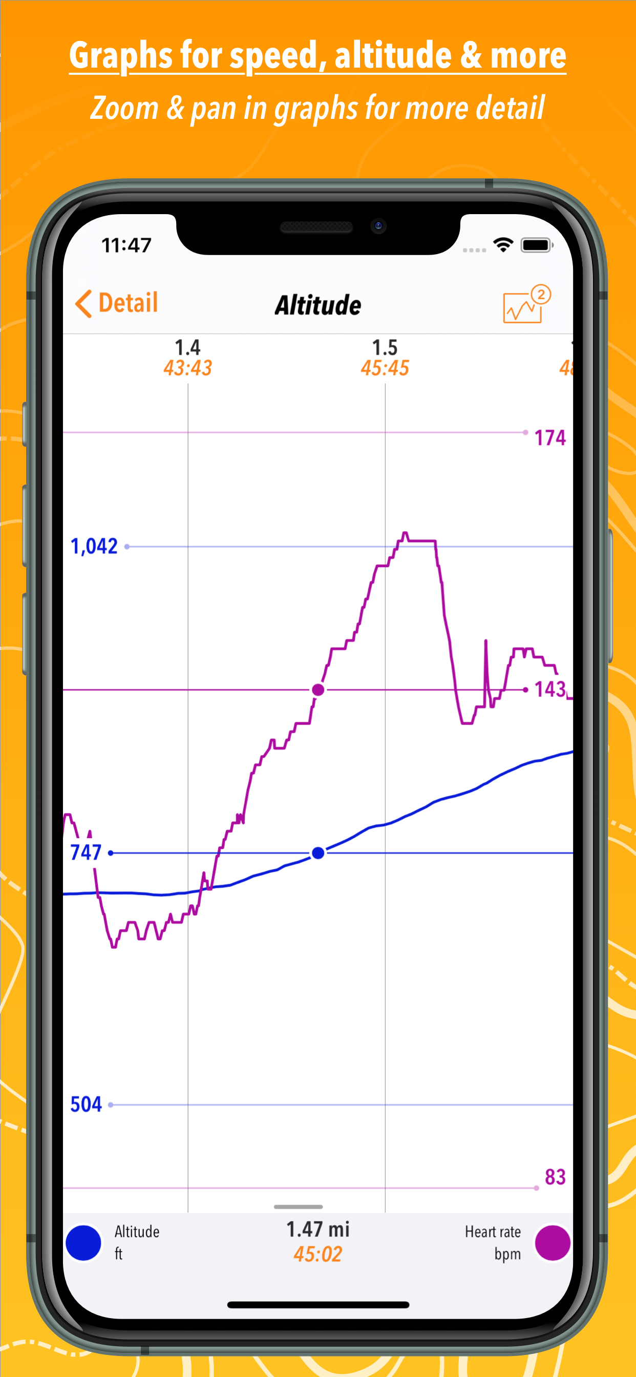
• Track analysis: Compare any two graphable statistics in zoomable, interactive graphs
• Heatmaps: Spot peaks at a glance
• Editing: Split and cut segments, insert waypoints

◉ Apple Watch Support

• Start and stop recordings, see live statistics, track your active energy & heart rate
• Apple Watch Series 2: Record GPS tracks without your phone

◉ Tightly Integrated

• Health & Activity app: Save track summaries to your Health database
• Today Widget: Start/stop recordings & see live statistics
• Siri: Start, stop, and resume recordings
• Spotlight (system search): Find existing tracks, waypoints and photos, or start recording from Spotlight
• 3D Touch on the homescreen: Access your last track or start recording immediately
• Bluetooth accessories: Pair external heart rate monitors and bike computers (cycling speed & cadence)

◉ Privacy-Focussed Sharing

• Wi-Fi sharing: View your tracks on a bigger screen without uploading them to the internet
• Export: Share tracks as GPX files, upload them directly to supported services, or create a weblink via Trails.io (see https://trails.io/s/2xal4g/ for an example)
• No login required, no automatic uploads or data sharing, no ads

◉ Trails Pro Features

• GPX file import via AirDrop, email attachment, weblink, or file provider extension (e.g., iCloud Drive or Dropbox)
• Offline topographic maps in various styles (powered by the OpenStreetMap community)
• Routing: Follow a track or a set of waypoints
• Unlimited recordings: Record as many tracks as your device can store
• Alerts: Audible alerts remind you in configurable intervals and read out one or more statistics

You can try out all other features and keep up to five tracks without Trails Pro. Record more tracks by deleting older recordings.

Trails Pro is available as a 3, 6, or 12 month subscription via in-app purchase. The subscription is non-recurring: It will end automatically after 3, 6, or 12 months respectively. No automatic re-billing, no hidden fees.

◉ Notes:

If you have any question about Trails, please don't hesitate to ask us! ([email protected])

Trails supports recording your location in the background. Please understand that continued use of location services can decrease battery life.
Hide.. Show more..

Screenshots

User Rating

3.13 out of 5

30 ratings in United States

5 star
10
4 star
5
3 star
3
2 star
3
1 star
9

Ratings History

Reviews

Amazing abandoned app

Lycestra on

Without a very affordable subscription, this app has limited utility. Abandoned, but still not outdated. Wish it had lasted longer. RIP

No Server? Abandoned? …Was Favorite Trail App

TravelKing92 on

(February 8th, ‘24) I Would give a full 5-Star review if it still…worked? Never had an app I loved and used so often take such a nosedive. I have used, and Greatly enjoyed this app for years. But the development team seemed to vanish or simply abandon their app. I am a software developer myself, and It does make me slightly angry to be honest. At this point, the app should obviously be taken down, but there in lies the problem…I have over 3 years worth of trails, maps, recordings, special and memorable trips, etc. and more within the app’s Servers. (Which on the app, it has said for well over a year now…that, “The servers can not be accessed: Check your internet connection and try again, or email for support” -_- It would be really unfortunate to lose all that acquired Data. PLEASE RESPOND OR PROVIDE A WAY TO TRANSFER MY DATA TO LITERALLY ANYTHHING ELSE. The App seems to still be “functioning”(ish)…but no access to servers and no help when requested. Do not download this app! Unless there is an update that’s NEW, or I will be the first one to update my review if anything changes. Come on guys, not cool to just disappear without so much as even an e-mail or notice that the money you’ve accepted from me isn’t going to truly get me anything. Feeling a bit scammed. Either way, its odd.

Won’t allow renewal of Trails Pro

TWC65 on

My one year subscription expired in February, and although I tried to renew it, it tells me it can’t connect to the server. Has this app been completely abandoned by its developer? Seems so.

Wish I could purchase Pro…

Mike 535 on

…but it’s not available from within the app. The section where it’s supposed to be just shows an error message that says to contact support. So I did and it’s been 12 hours now without a response on a weekday. The other good reviews are spot on, but they’re all using Pro features. If that’s what you’re aiming for, look elsewhere because you can’t buy Pro anymore.

Abandoned by developer?

Axomus on

I’ve used this app many, many times for recording hikes, mountain bike rides and walks. It’s great as a logbook for outdoor activities. For whatever reason, it’s be difficult to find a good outdoor GPS recording app, and this one so far has been the best. My favorite feature is automatically stopping the recording when you get back to your start spot. Simple, but so incredibly useful. That all being said, it’s been a VERY long time since the app has received any updates. As a paid subscriber, it’s starting to make me wonder what I’m paying for. I’m hoping they do another release in the near future incorporating new iOS 13 features, like dark mode. If there isn’t anything new soon, I’ll have to find an alternative.

Thank you for making this amazing app available.

Willem Andree on

I have been using the pro version of this app for more than 5 years without any issues on my iPhones. For those of you that complained about the subscription fees was unbelievable. For less than a cup of coffee you get all the pro features for an entire year and if your worried about updates, all I can say is if it ain’t broken, you don’t need to fix it. Thank you. Awesome app.

Lots to like here!

Pmenconi on

I found a lot to like with this app. I wanted a tracking app so I could geotag my photos: adding GPS coordinates to my travel photos so I would know where they were taken. Trails allows me to export the track file (email, Dropbox, iCloud…) so I can import it to my computer. Using a separate app (Lightroom) I can use the date and time from each photo, and the track log, to geotag the photos. I can also import the track into Google’s MyMaps to have a permanent record of that trip (hiking, biking, or by car). Trails also imports biking distances directly into the iPhone health app, so I can see how far I rode each week, months, etc. Yeah. Very useful.

Charges for everything

MarciAxsor on

Terrible!

NOT FREE- BE WARNED

swiftparticular on

This App is not free after the first month or so. After that you can’t use it, which is a shame, because it’s a nice program. Oh well.

Good for me

E7JAREHEAD on

I've tried just about every app like this and thought I found a couple. The time, milage, speed are right close to my watch. I like the interface I enjoy riding (which I'vr done a great deal). Not a racer but not one that rides a few mikes either. For medical issues I was homebond for 20 months. Ny encoligest last month recommended riding in s stationary bike. Told her no way was I peddling know where. Didn't want je on a two wheel as my boned are brittle. Mentioned a recumbent trike, she like thst idea so I brought one. aI want to lose the weight gained. Added to that I moved to because of the dr I was given(VA), so I'm not real familiar with the area. Won't ride main Streets, so anther issue. THIS app gived me speed(graft) distance, heart rate (graft), average speed, distance. I understand many others do basically the same but this is presented grafically in a way thst others are not. This is the first time I was able to set a pace and better abke to manage it without looking at my watch witch is a distraction at times. This will be the first app of its type that I will contribute to the Dev. Remember we have different needs, this app meets MY needs, then some

Store Rankings

Ranking History

App Ranking History not available yet

Category Rankings

App is not ranked yet

Keywords

Users may also like

Name
Cyclemeter Cycling Tracker
Road & Mountain Biking GPS
OutDoors GPS – Offline OS Maps
Plan Hiking & Biking Routes
Map My Tracks: ride run walk
GPS sport & outdoor tracker
Maps 3D - Hike & Bike
Routeplanner, navigation& maps
komoot - hike, bike & run
Your all-in-one route planner
Bike Ride Tracker: Bicycle GPS
Track distance & map routes
Map My Tracks: walking tracker
GPS walking and hiking tracker
Cairn: The Trail Safety App
Alerts, maps & cell coverage
MiCycle
Cycling Tracker with Analytics
Bike GPX
Show More

Revenue and Downloads

Gain valuable insights into Trails · Outdoor GPS Logbook performance with our analytics. Sign up now to access downloads, revenue, and more.

App Info

Publisher
iosphere GmbH
Languages
English, French, German, Kashmiri, Spanish
Recent version
4.09 (3 years ago )
Released on
Oct 16, 2014 (9 years ago )
Last updated
1 week ago