Very good app
Very good app


Yes, Yorkshire Three Peaks is completely free and it doesn't have any in-app purchases or subscriptions.
⚠️ The Yorkshire Three Peaks app has poor ratings and negative feedback. Users seem unsatisfied with its performance or features.
Yorkshire Three Peaks is free.
To get estimated revenue of Yorkshire Three Peaks app and other AppStore insights you can sign up to AppTail Mobile Analytics Platform.

Very good app
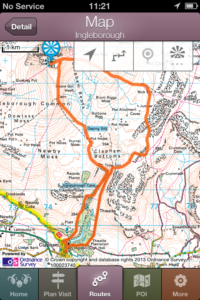
The app is a great way to support the Three Peaks routes. Does more than I thought it would. Minor issues: Features - North and distance markers / grid not shown on maps Content - Ingleton is no where near the Horton-in Ribblesdale railway station as mentioned on the Inglebrough walk
So I did the Ingleborough route today, and it was correct. The directions are OK, and it is not the app developer’s fault the arrow has fallen off the crucial path signpost where Horton and Clapham walkers part company on the way down. I thought I had overshot the turning, and it was only in hindsight using Viewranger that I had definitely gone the correct way. If the route stated the footpath joined the Pennine Bridleway I wouldn’t have felt lost for so long. The app is a bit odd: -The graphics/buttons are from the iPod touch 2nd generation era. The use of buttons to link back to previous pages is inconsistent. -The Feedback button opens a box and lets you type, but you can’t submit it as it contains “invalid arguments”. -I don’t know what “Layar” is, but that doesn’t work either - it generates a security error message on a third party website. -The GPS functionality DEFINITELY isn’t in there. I’m running 12.4 on an SE. The arrowhead button on the map legend does nothing, and there is no entry for the app in Location Services. I had 4G reception almost all the way round too. -Once you click “Start” on the route instructions page you are taken to the map. It’s a nice touch that there is a stopwatch function, but 1)The distance doesn’t change (because the GPS isn’t there), and 2)If you want to toggle back to the text instructions you have to abandon your timing, which then resets when you “Start” again. It’s worth £2.99 at the moment, just. It NEEDS to be brought up to date, to match the website.
Downloaded ios version for iPad. Simply doesn't work. Just presents as small window in middle of screen and will not enlarge to full screen. Shame on Yorkshire Dales NP for promoting it. Waste of money
It would appear that whatever bugs were causing problems for the previous reviewer are no longer an issue, at least not on my iPhone which is currently running iOS 11.4.1
Do not waste youur time and money with this app - it just doesn't work! How did it even end up on the App Store?? In case people aren't fully aware, 1 star = I hate it.
App won't run. Blank pages
No maps, no gps, useless. Absolute waste of £2.99. attempts made to contact the developer with no response.
This app required wifi to work, which there is non on the trail so you won't be able to use it on the day. Mine has now broken completely and only shows white blank pages on any selected buttons from the bottom. Can't even leave feedback whilst in the app as it keeps saying error. Payed £2.99 for it. Doesn't work. Don't bother using.
looks good when first installed,, planned my route,,turned up at horton,, opend the app to follow 3 peaks route,, didnt work,,, no location services workin ,, was as much use as doin the walk in a welding mask,
|
Chart
|
Category
|
Rank
|
|---|---|---|
|
Top Paid
|
|
6
|
|
Top Grossing
|
|
99
|
|
Top Paid
|

|
152
|
|
Top Paid
|

|
161
|
|
Top Paid
|
|
188
|
| Name | Downloads (30d) | Monthly Revenue | Reviews | Ratings | Recent release | |
|---|---|---|---|---|---|---|

Hill Lists
Munros, Wainwrights and more
|
Unlock
|
Unlock
|
0
|
|
1 month ago | |
MalvernsWalks
|
Unlock
|
Unlock
|
0
|
|
8 months ago | |

Stockeld Park
Get the most from your day out
|
Unlock
|
Unlock
|
0
|
|
1 month ago | |

Llwybrau'r Wyddfa
Yr Wyddfa walking routes
|
Unlock
|
Unlock
|
0
|
|
6 months ago | |

Derbyshire Walks
200+ Walks in Derbyshire
|
Unlock
|
Unlock
|
0
|
|
1 year ago | |
Peak District Map
National Park Topo Map
|
Unlock
|
Unlock
|
0
|
|
3 years ago | |
Yorkshire Dales Map
|
Unlock
|
Unlock
|
0
|
|
3 years ago | |

Parcio Eryri Parking Snowdonia
|
Unlock
|
Unlock
|
0
|
|
4 months ago | |

Muncaster
|
Unlock
|
Unlock
|
0
|
|
2 years ago | |

Scafell Pike Offline Map
Cheaper and Simpler!
|
Unlock
|
Unlock
|
0
|
|
1 year ago |
