Battery draining
Even after force closing the app is draining my battery. Fix this fast!!


Ja, LeadNav GPS ist kostenlos herunterzuladen, enthält jedoch In-App-Käufe oder Abonnements.
🤔 Die Qualität der LeadNav GPS-App ist gemischt. Einige Nutzer sind zufrieden, während andere Probleme melden. Ziehen Sie in Betracht, einzelne Bewertungen für mehr Kontext zu lesen.
LeadNav GPS bietet mehrere In-App-Käufe/Abonnements, der durchschnittliche In-App-Preis beträgt €113.55.
Um geschätzte Einnahmen der LeadNav GPS-App und weitere AppStore-Einblicke zu erhalten, können Sie sich bei der AppTail Mobile Analytics Platform anmelden.

Even after force closing the app is draining my battery. Fix this fast!!
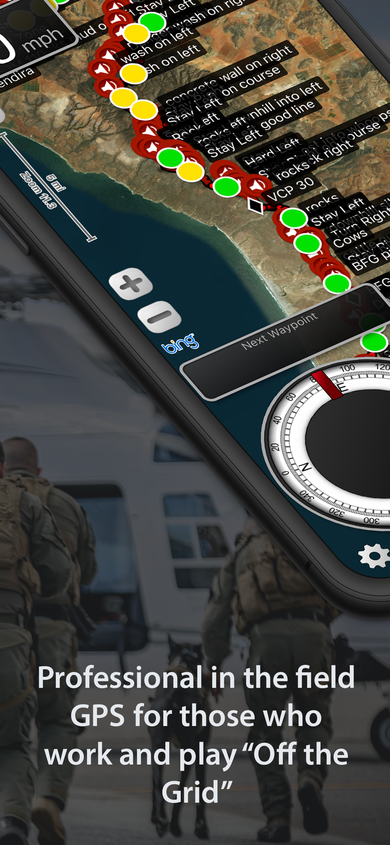
LeadNav is the ultimate iOS gps app. Nothing from Racing in Baja to the weekender UTV guy in the desert. The versatility and in app upgrades set it apart, if you are serious about you mapping and navigating offroad this is the ONLY app you need.
I’ve been using LeadNav for about 4 years now and it’s become an indispensable asset for off-road racing and navigation. While many seem to have jumped on the bandwagon of new apps because of their baked in routes, it’s nowhere near the functionality of LeadNav. I love the route creation feature and the audio cues are a complete game changer for me as a moto racer. Keep up the good work Damien!
How is it 2022 almost 2023 and all the files are not alphabetical order. I have over 100 maps and takes forever to pick the correct one. Also make it so we can call out way points in advance. Once you go through all that it’s an ok program. Once that is fixed I’ll pay for the high package.
I bought a military humvee from the gov auction…like an idiot. It showed up new and so incredibly awesome. I have no experience and no experience, also I don’t know what I am doing. But this machine is so capable it just takes me everywhere. I am too wide for the UTV trails so I get caught in washes and slot canyons. I needed something and started digging around. This software is not only preferred by the hardcore racing teams I know, my new fabricator uses it on his toys, but surprising I was in contact with another gps system developer that uses the same GPS puck thing and they admitted LEADNAV has really provided the best option for in the field off-road route acquisition. It’s insane how even more capable I am now. I had to buy an iPad and learn from level zero, even just simple iPad buttons, but this system has completely changed my quality life. With this software now, We can leave from the house and search out historical landmarks, from plane wrecks to mines, to public hunting cabins. We can load up the kids to search out wildlife tanks, desert springs, Native American grinding pots that I had no idea were all within a 2 hour radius and plan the route in my new humvee to get there. So easy it’s actually fun to do. Lots of online training available, but you could figure it out on your own. AND I have reached out to the developer and received personal replies answering my question fully and guiding me to a more efficient tip, which he didn’t need to do. If you don’t have this software you are doing it wrong. I need to screen shot my master map with like 100 markers and 20 routes that reaches about 50 mile radius. This is a mush have for anyone camping or off-roading. You have no idea what cool stuff is just around the corner. And you can import all the other app trails and overlay them on these maps. This is a game changer. And once set up you don,t need a signal. On a side note: A camping iPad was not really a priority of mine, but now that I have it, I am not mad about that either. It runs my lights and dash cam. Runs my offline stereo library. Has a few movies for road trips or the 3 and 5 yr old to do puzzles on while in the RV. Cant do that on a garmin or fish finder thingy which I also looked into. I bought it for this software but really everything is better once I committed to LEADNAV.
Wasn’t totally clear that the 5 seat license claimed by the PRO level licensing is through Apple’s account licensing so be aware that you have to have all of your devices tied to the same appleid in order to use them. Additionally, when the automatic download of apps put the app on my iPad (after I installed it first on my iPhone), it did not recognize the license even if I tried to restore purchases. This might be a bug or quirk with the app getting auto installed on the iPad before I purchased the license. Deleting the app from the iPad and installing it again seems to have fixed the issue in case others run into the same thing. FYI on this nuance for the developer and appreciate they responded to my initial review after a few days so I’ve revised my original post.
We bought this app on recommendation from a company we rented a doonbuggy from for a ride in the desert. We were told it worked on satellite so even if we lost cell reception the app would still guide our way. We followed the map for 1hr into the Sonoran desert when we lost the signal. At this point we were without Satellite GPS, we had no cell service and were completely lost in the middle of the desert in 104 degree heat. Our only option was to retrace our path and find our way back to the main road as we had not passed a single person on our entire journey. To say this app was more than a waste of $20 is an understatement!! The stress we experienced on this excursion is beyond ridiculous.
I have been using lead nav for years and loved it. Now they want $250 for off line maps! Nope.
I paid the $20 to be able to upload my own GPX maps and now they’ve taken that ability away and want $250 per year to be able to do what I originally paid for. Not cool. I will be seeking a refund.
I’m a co driver for KOH, BITD, and SCORE and this is the only GPS system I use. Easy to use and mark hazards and VCP’s. If you are racing this is a must use. Plus every time I’ve had a question it get answer pretty quick via Instagram. Thank you keep up the great work!
|
Diagramm
|
Kategorie
|
Rang
|
|---|---|---|
|
Top Bezahlt
|

|
4
|
|
Top Bezahlt
|

|
8
|
|
Top Bezahlt
|

|
15
|
|
Top Bezahlt
|

|
17
|
|
Top Bezahlt
|

|
21
|
| Name | Rezensionen | Bewertungen | Letzte Veröffentlichung | |
|---|---|---|---|---|

GPX-Viewer
View GPX files
|
2
|
1
|
vor 3 Wochen | |

ARA GPX Viewer
|
3
|
|
vor 2 Jahren | |

Lowrance: app para pescadores
Las mejores cartas pesqueras
|
14
|
3
|
vor 1 Woche | |

GPX Viewer PRO
GPS tracks y waypoints
|
3
|
|
vor 1 Monat | |

Trails Offroad
4WD Offroad / Overland Trails
|
0
|
|
vor 3 Wochen | |

SonsOfSmokey
Wilderness Defense
|
0
|
|
vor 1 Jahr | |

Rally Roadbook Reader
Rally Navigator Mobile App
|
1
|
|
vor 1 Jahr | |

Mob Armor GPS
|
0
|
|
vor 1 Jahr | |
MAP E32
|
0
|
|
vor 2 Jahren | |

Tread®
|
13
|
2
|
vor 1 Monat |
