
Marine Navigation Lite
Beschreibung
RELIABLE. EASY. YOURS FOREVER.
Marine Navigation is the GPS chartplotter designed for sailors, fishermen, and sea lovers who want freedom and full control, even offline.
Tired of expensive annual subscriptions just to navigate? Marine Navigation is the GPS chartplotter you buy once and own forever.
With the revolutionary PRO feature, you can photograph your personal charts, import satellite images, and navigate with them. No more paid maps.
Whether you are sailing offshore, anchoring in a hidden bay, or fishing in your secret spot, Marine Navigation is the tool that goes wherever you go. Even without an internet connection.
---
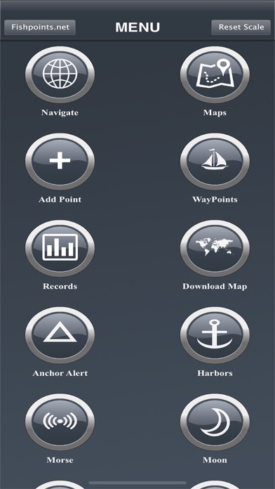
HOW OUR ECOSYSTEM WORKS
1. Try it for free: Search for “Marine Navigation Lite” to explore the basic features.
2. Buy the Full Version (this app): A complete, offline GPS chartplotter that is yours forever.
3. Unlock the power of PRO (optional): Activate a subscription for advanced features not found elsewhere.
---
WHAT IS INCLUDED IN THE FULL VERSION
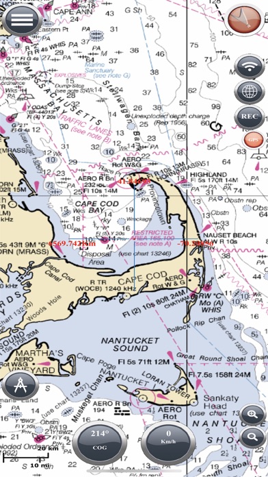
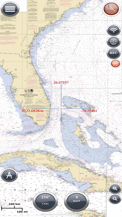
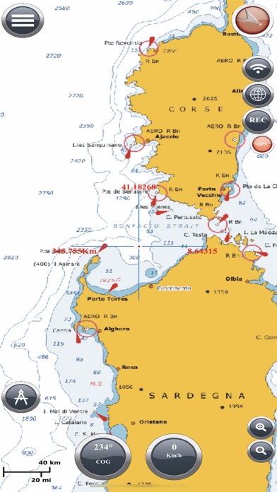
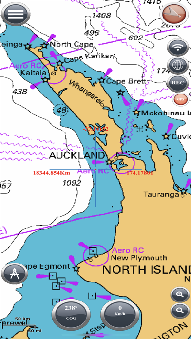
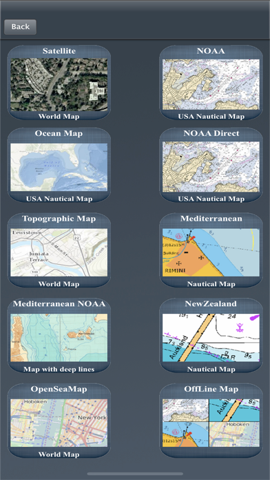
OFFLINE NAUTICAL CHARTS
Access detailed worldwide marine maps directly on your device, no internet required.
Choose from multiple layers including:
- NOAA Raster and ENC: Official U.S. nautical charts
- OpenSeaMap: Global coverage with navigational aids, buoys, and lights
- ESRI Satellite: Detailed imagery for coastlines and inland areas
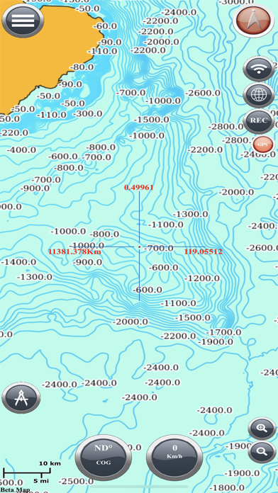
- Bathymetric Maps: Depth contours and underwater terrain
- Marine Navigation BETA Layer: Our exclusive experimental chart for advanced exploration.
*Preview all maps at: www.fishpoints.net/mapsview*
CUSTOM MAP IMPORT (WITH LIMITATIONS)
Already in the Full Version, you can try our exclusive image-to-map tool.
Import one custom image (up to 1280x1280 pixels) and navigate with it offline in an area up to 5x5 kilometers.
Use any image: A photo of a paper chart, a fishing map found online, or a satellite snapshot of your favorite bay.
Align it using 3 matching reference points to link your map to real-world GPS positions.
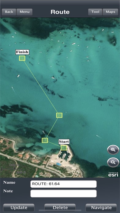
COMPLETE GPS NAVIGATION
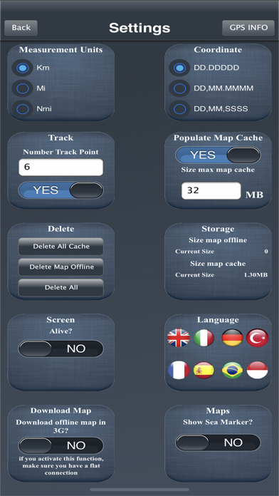
Routes, tracks, unlimited waypoints, compass (true or magnetic), anchor alarm, speed, and direction.
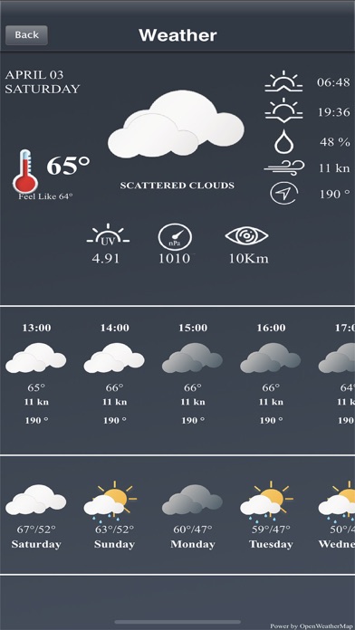
USEFUL TOOLS
Basic weather, moon phases, SOS Morse code, GPX import and export.
---
UPGRADE TO PRO – OPTIONAL SUBSCRIPTION
Are you an experienced navigator or a fisherman who protects his best spots? With the PRO version you can:
- Import unlimited maps: Scan paper charts, load satellite imagery, or even a treasure map.
- Load high-resolution images with no size or geographic limits.
- Overlay multiple maps, adjust transparency, and customize every detail.
- Fully offline tide calculations, based on the high-precision FES2022b global model ( powered by Noveltis, LEGOS, CLS and CNES). Now you can check tide forecasts without needing an internet connection, right on the map. Calculate tides for: Waypoints. Any point selected with the crosshair. Major ports.
Why choose PRO:
- Save hundreds by avoiding expensive subscription-based systems.
- Navigate using rare or personal maps (hidden bays, wrecks, fishing zones).
- Achieve a level of precision and control that competitors cannot match.
---
WHY CHOOSE MARINE NAVIGATION
- Proven reliability since 2009
- Works fully offline, even in open water
- Guaranteed privacy: Your data stays on your device
---
IMPORTANT NOTICE
Good seamanship requires the use of official charts. Marine Navigation is for use with other charts and cannot replace official charts. Use at your own risk.
SUBSCRIPTION INFORMATION
- The PRO subscription renews automatically unless turned off at least 24 hours before the end of the current period.
- You can manage or disable auto-renew in your iTunes Account Settings after purchase.
---
Learn more on our official website:
www.fishpoints.net
Terms of Use:
http://www.fishpoints.net/eula/
Privacy Policy:
http://www.fishpoints.net/privacy-policy/
Try Marine Navigation and take the helm of your journey. The sea is yours.
In-App-Käufe
- Remove Ads Forever
- USD 2.99
- 1 Year Subscription
- USD 7.99
- Remove Ads (1 Year)
- USD 1.49
- Full Version Forever
- USD 10.99
- Monthly Subscription
- USD 0.99
- Remove Ads SixMonths
- USD 0.99
- 6 Months Subscription
- USD 4.49
- Update to Full Version 1 Year
- USD 3.49
- Update to Full Version 6Months
- USD 2.49
Screenshots
Marine Navigation Lite Häufige Fragen
-
Ist Marine Navigation Lite kostenlos?
Ja, Marine Navigation Lite ist kostenlos herunterzuladen, enthält jedoch In-App-Käufe oder Abonnements.
-
Ist Marine Navigation Lite seriös?
Nicht genügend Bewertungen, um eine zuverlässige Einschätzung vorzunehmen. Die App benötigt mehr Nutzerfeedback.
Danke für die Stimme -
Wie viel kostet Marine Navigation Lite?
Marine Navigation Lite bietet mehrere In-App-Käufe/Abonnements, der durchschnittliche In-App-Preis beträgt USD 3.99.
-
Wie hoch ist der Umsatz von Marine Navigation Lite?
Um geschätzte Einnahmen der Marine Navigation Lite-App und weitere AppStore-Einblicke zu erhalten, können Sie sich bei der AppTail Mobile Analytics Platform anmelden.

Marine Navigation Lite Bewertungen
Store-Rankings
|
Diagramm
|
Kategorie
|
Rang
|
|---|---|---|
|
Top Umsatz
|

|
14
|
|
Top Kostenlos
|

|
176
|
|
Top Kostenlos
|

|
229
|
|
Top Kostenlos
|

|
268
|
|
Top Kostenlos
|

|
310
|
Schlüsselwörter
Marine Navigation Lite Konkurrenten
Marine Navigation Lite Installationen
Letzte 30 Tage
Marine Navigation Lite Umsatz
Letzte 30 TageMarine Navigation Lite Einnahmen und Downloads
Melden Sie sich jetzt an, um Zugriff auf Downloads, Einnahmen und mehr zu erhalten.
App-Informationen
- Kategorie
- Navigation
- Herausgeber
- Marco Palaferri
- Sprachen
- English, Czech, Danish, Dutch, Finnish, French, German, Greek (modern), Hebrew (modern), Indonesian, Italian, Japanese, Korean, Malay, Norwegian Bokmål, Polish, Portuguese, Russian, Chinese, Spanish, Swedish, Thai, Turkish, Vietnamese
- Letzte Veröffentlichung
- 12.0.66 (vor 1 Woche )
- Veröffentlicht am
- Mar 6, 2013 (vor 12 Jahren )
- Auch verfügbar in
- Vereinigte Staaten, Griechenland, Malta, Sonderverwaltungsregion Hongkong, Belgien, Kasachstan, Brunei Darussalam, Ecuador, Irland, Chile, China, Saudi-Arabien, Israel, Indonesien, Kuwait, Vereinigtes Königreich, Vietnam, Island, Tschechien, Zypern, Portugal, Kanada, Thailand, Südafrika, Nordmazedonien, Spanien, Australien, Neuseeland, Taiwan, Indien, Slowenien, Vereinigte Arabische Emirate, Aserbaidschan, Deutschland, Schweden, Nepal, Tunesien, Nigeria, Japan, Norwegen, Südkorea, Armenien, Schweiz, Lettland, Mexiko, Finnland, Türkei, Niederlande, Litauen, Kroatien, Frankreich, Pakistan, Bulgarien, Usbekistan, Ungarn, Österreich, Sri Lanka, Ägypten, Brasilien, Rumänien, Argentinien, Madagaskar, Algerien, Katar, Philippinen, Polen, Dänemark, Dominikanische Republik, Kolumbien, Ukraine, Italien, Bahrain, Singapur, Libanon, Slowakei
- Zuletzt aktualisiert
- vor 4 Monaten
- © 2025 AppTail.
- Unterstützung
- Privacy
- Terms
- All Apps