Marine Navigation Lite

Offline GPS tracker for boat

Veröffentlicht von: Marco Palaferri

Beschreibung

MARINE NAVIGATION
Find your road on the sea! GPS chartplotter for boating.
An easy-to-use offline GPS tracker and route planner featuring worldwide offline maps.
Navigate with your favorite device around the world, turn your smartphone or tablet into a GPS navigator with an offline map, ideal for sea, rivers and lakes, for boaters, fishermen and water sports.
This application is dedicated to the sea and the people who love it and live it with passion.
WHAT MAKES IT A BEST GPS TRACKER OR NAVIGATOR
Offline GPS tracker for boat navigation. GPS Chartplotter for Sailing & boating.
Morse Code in case of danger, Anchor Alert to prevent the drift of the anchor, Weather and Moon Phase to show the forecast during the day, Harbors to see the list of ports, Sync Waypoints to be able to create backups and access them from different devices.
You also get to download the maps and marine charts, so you won’t need an active internet connection when it comes to getting navigation and route planning. If you create a profile, you can save waypoints and routes to access them from different devices. All you have to do is logging in with the same account and enjoy seamless sea GPS navigations.
So, no matter you are a professional sailor or fisherman, or you are an amateur who like traveling in the sea, Marine Navigation has got you covered. It’s a versatile sea navigator app and boating route planner which provides accurate GPS Chartplotter and marine charts.
MAPS OFFLINE:
Download maps or marine charts, you need a select area and application save tile into your device. Navigate on preloaded maps without connection.
MAPS AND MARINE CHARTS:
MapView: http://www.fishpoints.net/mapsview/
•Nautical maps of the United States of America by NOAA
•Nautical maps of the Mediterranean by NOAA
•Mediterranean RNC
•Nautical maps of the NewZealand by LINZ
•Maps of the world’s oceans and coastal areas by ESRI
•World topographic map includes boundaries, cities, water features, ports, physiographic features by ESRI
•Satellite imagery for the world by ESRI
•Maps for the sea, with ports, sea light and more by Open Sea Map
Marine Navigation: GPS Tracker Main Features at a Glance
•Super easy to use GPS tracker tool
•Clean and neat design
•Weather
•GPX Import & Export
•Available in different languages: English, Italian, French, Spanish, Brazilian, Turkish and German,Indonesian
•Download Maps to use in offline mode
•Accurate and detailed GPS Chartplotter, GPS plotter and Marine charts
•Optimized for phones and tablets
•Moon phase
•Morse Code
•Receive information about speed, direction, time to arrival
•Compass Magnetic or True
•Change Measurement Units: Km, Mi, or Nmi
•Record your route for analyze the data and navigate again
LOCATION PERMISSION
Location information is processed locally on your device, ensuring your privacy.
HELP US
Download Marine Navigation and let us know about any bugs, feature requests or any other suggestions. Stay tuned for more features and options in this GPS tracker app for boating.
WARNING
Good seamanship requires the use of official charts. Marine Navigation is for use with other charts and cannot replace official charts. Use at your own risk.
LEARN MORE ABOUT FISHPOINTS
http://www.fishpoints.net
IMPORTANT INFORMATION ABOUT SUBSCRIPTIONS
Payment: will be charged to iTunes Account at confirmation of purchase.
Subscription: is automatically renewed on the same account, unless the automatic renewal is deactivated at least 24 hours before the end of the current period.
Manage Subscription: auto-renewal may be turned off by going to the user's Account Itunes Settings after purchase.

A link to the terms of use: http://www.fishpoints.net/eula/
A link to the privacy policy: http://www.fishpoints.net/privacy-policy
Ausblenden Mehr anzeigen...

In-App-Käufe

Remove Ads Forever
2,99 €
1 Year Subscription
8,99 €
Remove Ads (1 Year)
1,49 €
Full Version Forever
11,99 €
Monthly Subscription
0,99 €
Remove Ads SixMonths
0,99 €
6 Months Subscription
4,99 €
Update to Full Version 1 Year
3,49 €
Update to Full Version 6Months
2,49 €

Screenshots

Marine Navigation Lite Häufige Fragen

  • Ist Marine Navigation Lite kostenlos?

    Ja, Marine Navigation Lite ist kostenlos herunterzuladen, enthält jedoch In-App-Käufe oder Abonnements.

  • Ist Marine Navigation Lite seriös?

    Nicht genügend Bewertungen, um eine zuverlässige Einschätzung vorzunehmen. Die App benötigt mehr Nutzerfeedback.

    Danke für die Stimme

  • Wie viel kostet Marine Navigation Lite?

    Marine Navigation Lite bietet mehrere In-App-Käufe/Abonnements, der durchschnittliche In-App-Preis beträgt €4.27.

  • Wie hoch ist der Umsatz von Marine Navigation Lite?

    Um geschätzte Einnahmen der Marine Navigation Lite-App und weitere AppStore-Einblicke zu erhalten, können Sie sich bei der AppTail Mobile Analytics Platform anmelden.

Benutzerbewertung
Die App ist in Spanien noch nicht bewertet.
Bewertungsverlauf

Marine Navigation Lite Bewertungen

No vale para nada

Supergus111 on

Spanien

No la compréis, no vale la pena ni descargarla

Que no te engañen

Davidestafado on

Spanien

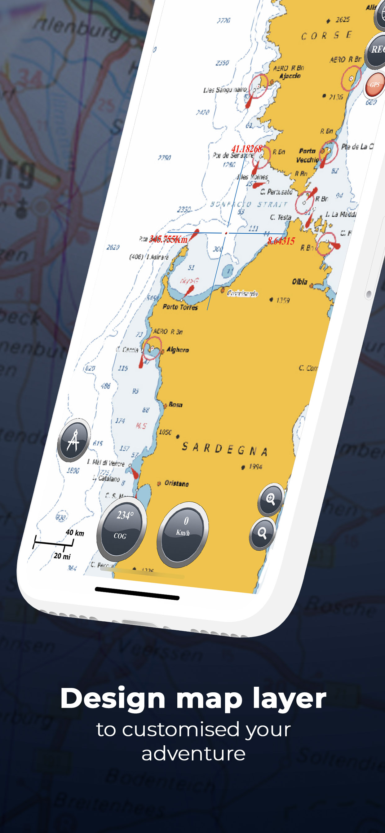
Buenas tardes usuarios marineros , no os descarguéis esta app es una estafa y más la de pago es una foto escaneada de una carta de navegación , cuando haces zoom a escala inferior de 5 km pixela y no aparece las profundidades como indica la foto principal

Store-Rankings

Ranking-Verlauf
App-Ranking-Verlauf noch nicht verfügbar
Kategorien-Rankings
Diagramm
Kategorie
Rang
Top Umsatz
36
Top Umsatz
90
Top Kostenlos
93
Top Kostenlos
132
Top Kostenlos
281

Schlüsselwörter

Marine Navigation Lite Konkurrenten

Name
AIS Maps: Marine & Lake charts
Detailed nautical & topo maps
Atlas Cartas Náuticas
Mares y Lagos Cartas Náuticas
PRO CHARTS - Marine Navigation
Aqua Map Boating
Navegación GPS, vela y pesca
TZ iBoat – Marine Navigation
Carta náutica, GPS… para barco
NV Charts GPS Navigation AIS
Marine Navigation and Boating
WinGPS Marine
SeaNav
Marine Charts and Navigation
Seawell Navigation Charts
Sea Navigation Marine Offline
OnCourse - boating & sailing
Navigation - mAIS

Marine Navigation Lite Installationen

Letzte 30 Tage

Marine Navigation Lite Umsatz

Letzte 30 Tage

Marine Navigation Lite Einnahmen und Downloads

Gewinnen Sie wertvolle Einblicke in die Leistung von Marine Navigation Lite mit unserer Analytik.
Melden Sie sich jetzt an, um Zugriff auf Downloads, Einnahmen und mehr zu erhalten.

App-Informationen

Kategorie
Navigation
Herausgeber
Marco Palaferri
Sprachen
Czech, Danish, Dutch, English, Finnish, French, German, Greek (modern), Hebrew (modern), Indonesian, Italian, Japanese, Korean, Malay, Norwegian Bokmål, Polish, Portuguese, Russian, Chinese, Spanish, Swedish, Thai, Chinese, Turkish, Vietnamese
Letzte Veröffentlichung
9.3.1 (vor 6 Monaten )
Veröffentlicht am
Mar 6, 2013 (vor 11 Jahren )
Zuletzt aktualisiert
vor 3 Tagen