Memory-Map for All

Offline Mapping GPS Navigation

Veröffentlicht von: Memory-Map

Beschreibung

Download maps for Offline GPS Navigation. No mobile data connection required.
Your favorite maps and charts from OS, Hema, NOAA, and many more.
Fully customizable map, data display and toolbar buttons.
Powerful overlay data management, using nested categories and GPX files
Backup and load maps from thumb drive.
Use the same maps and sync your overlay data to other mobile devices and desktop computers
Interactive Route Profile showing terrain elevation
Track Altitude and Speed profile graphs
Show terrain ascent, descent, max elevation and estimated time for planned route
The Memory-Map for All app turns your phone or tablet into a full-featured Outdoor GPS or Marine Chart Plotter, and allows you to navigate with USGS Topo maps, NOAA Marine charts, and many other specialist maps, without needing a mobile internet signal.
Maps are downloaded on-the-fly and can be pre-loaded, so they are ready to be used offline. Once the app and maps are loaded to the phone or tablet, cellular network coverage or internet connection is not required for real time GPS navigation.
The Memory-Map for All app can be used as a standalone GPS navigator, but it can also be used in conjunction with the Windows PC or Mac app (free download) for planning, printing and loading up maps, waypoints and routes to the phone/tablet.
Memory-Map for All includes free access to 1:250,000 scale topographic maps and many other free maps around the world. More detailed maps are available for download and purchase with a free try-before-you-buy, time-limited demo option. Available maps include Ordnance Survey, Hema, USGS quads, NOAA, UKHO, and DeLorme. Maps can be used on your PC as well as your phone and tablet. The Cloud Sync feature allows you to keep the overlay data consistent on all your devices.
Features include:
Access a vast range of Worldwide maps and charts.
Automatically downloads a free map of your current location
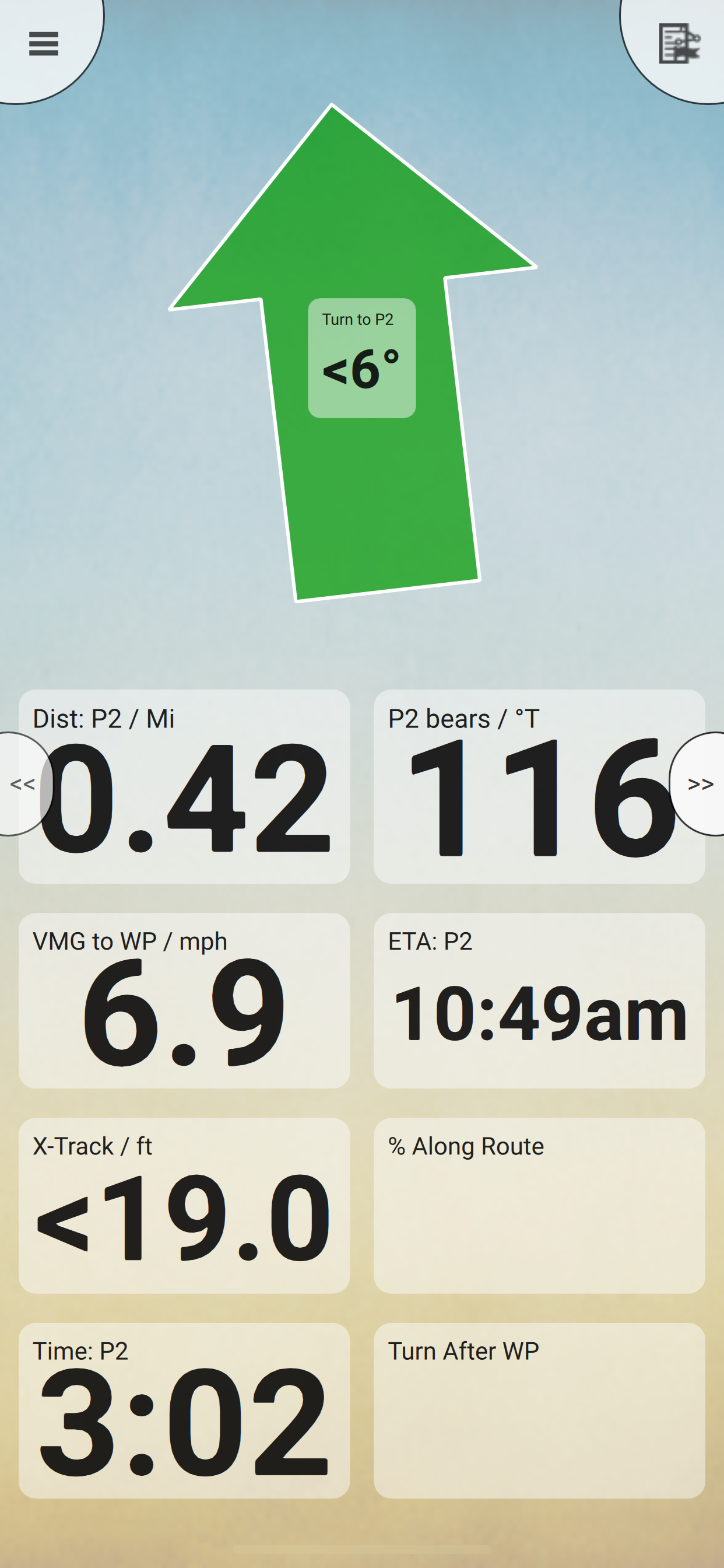
Create and edit marks and routes.
Import and export marks, routes and tracks in the open GPX format
Interactive graphs of terrain elevation, GPS Altitude and Speed profile
Display; Position, Course, Speed, Heading, Altitude and averages
Position coordinates include Lat/Long, UTM, GB Grid, Irish Grid, Military Grid.
Units displayed in Statute, Nautical or Metric, with separate unit setting for Height
Support for GPS and Compass sensors, where available.
Placename search index can be used offline.
Moving map, lock GPS position and automatically scroll the map
Records breadcrumb trail / tracklogs.
Share position marks, routes and tracklogs as GPX files
Full marine instrumentation features, with AIS, DSC and Anchor alarm
NMEA data interface via WiFi
Barometer & relative altitude
Import custom icons for POI
Ausblenden Mehr anzeigen...

Screenshots

Memory Häufige Fragen

  • Ist Memory kostenlos?

    Ja, Memory ist komplett kostenlos und enthält keine In-App-Käufe oder Abonnements.

  • Ist Memory seriös?

    ✅ Die Memory-App scheint von hoher Qualität und legitim zu sein. Die Nutzer sind sehr zufrieden.

    Danke für die Stimme

  • Wie viel kostet Memory?

    Memory ist kostenlos.

  • Wie hoch ist der Umsatz von Memory?

    Um geschätzte Einnahmen der Memory-App und weitere AppStore-Einblicke zu erhalten, können Sie sich bei der AppTail Mobile Analytics Platform anmelden.

Benutzerbewertung

3 von 5

1 Bewertungen in Kanada

5 star
0
4 star
0
3 star
1
2 star
0
1 star
0
Bewertungsverlauf

Memory Bewertungen

Much better than the OS app

A Nonymous (of course) on

Vereinigtes Königreich

I had previously used ViewRanger on my iPad mini for UK hill walking, with downloaded OS maps. When that app sadly disappeared (taking “my” purchased map segments with it) I hunted around for a useable alternative. The “official” OS app remains frustratingly not-quite-useable, so I’ve given up on it. MemoryMap isn’t perfect, but it’s certainly the best available way to download and use OS maps on your iPad for hill walking. Great that we can purchase “lifetime” access to the maps (at least until MemoryMap goes bust, gets bought out, or whatever). The user interface for downloading map data for specific areas onto the iPad is non-intuitive, but does work. So, how could it be improved? My main gripe is that cut-and-paste on the Mac desktop application doesn’t work. Come on guys, this is the 21st century! Competent UI design doesn’t get any more basic than this. Needless to say, I always carry a paper OS map as a backup, but with MemoryMap I never have to use it. Although the paper map will still be mine, and still useable, in 10 or 20 years’ time. Let’s hope the same is true for “my” MemoryMap maps.

Excellent mapping App

Pocketmuncha on

Vereinigtes Königreich

I’ve used Memory Map software and app for years. Really simple to use, I prefer the fact you can buy maps rather than pay an annual subscription. Great functionality.

Brilliant Software

Skipper Dave on

Vereinigtes Königreich

I have used Memory-Map for many years and more recently, Memory-Map for All. I use it with ordinance survey maps to plan walks in the UK and with Admiralty charts for Sailing both around the UK and further field. The app is extremely easy to use both on land and at sea.

Happy marine user

Pmjd55 on

Vereinigtes Königreich

Took a while to adapt but very happy now. Each of these apps has their own quirks but am planning to use while sailing in Scotland this year including Antares charts which I purchased.

First Class App

Johnny Jumpups on

Vereinigtes Königreich

Having now used several mapping apps featuring routes, tracks and marks, Memory Map 4 All is by far the best and includes almost all the features I need. The latest version now allows custom icons and the ability to filter by overlays which is extremely useful. All the normal route planning features work well. I personally would like to be able to find locations using postcode and OS grid reference as well as by name but the name search is very powerful. It would also be good to have a location beacon within the software which I have used elsewhere. The support team are extremely helpful too but the app is intuitive anyway and easy to use. Updates are affordable too. All in all a 5 star experience. John Walton www.englishfords.co.uk

Still waiting for CarPlay?

Welshchris on

Vereinigtes Königreich

Great app - but OS maps in CarPlay is a no brainer! - is this in your development plan?

Excellent as you would expect from Memory Map

Havelec on

Vereinigtes Königreich

I’ve used memory map software for years, mainly to plan my walking routes and then transferred them to a gps unit. The last unit I had was a sat map and since they have folded I was considering going back to Garmin, but with the memory map 4 all software I can just use my iPhone instead. The software allows me still to plan routes on my iMac and then save then to iCloud so I can access them on my phone. Alternatively I can download routes from websites and transfer them that way. As the mapping is full OS 1:25 they are great to follow (although I always carry a paper map & compass for backup safety). If you don’t have the relevant map you can print your route and use that. The only gripe is that with a Mac you don’t get all the features that are available to PC users, please can you sort this out as it’s a little annoying.

Oldest and best

shobby1 on

Vereinigtes Königreich

I started out using memory map many moons ago; used viewranger for a time until they sold out, before moving back to memory map and happy I did. Plenty of maps available including French topographical, useful for paths in France (obviously).

Great

dylan no muscles. on

Vereinigtes Königreich

Thank you memory map. Helped me out of a few scrapes.

A Good App for Navigating

Farrandes on

Vereinigtes Königreich

This is a good app for creating and following routes in serious mountain and marine environments. The map quality is the best I have seen. It’s not an intuitive app to use though so you need to spend some time learning how to use it before you go outdoors and find you can’t get it work how you want to. It’s probably one of the best apps that I am aware of, including the OS map app and Outdoor Active.

Store-Rankings

Ranking-Verlauf
App-Ranking-Verlauf noch nicht verfügbar
Kategorien-Rankings
Diagramm
Kategorie
Rang
Top Kostenlos
136
Top Kostenlos
307

Schlüsselwörter

Memory Konkurrenten

Name
4WD Maps - Offline Topo Maps
Offroad 4x4 GPS Navigation
Drive Locations AU
NV Charts GPS Navigation AIS
Marine Navigation and Boating
Seapilot
Compass Eye Bearing Compass
Augmented Reality compass
OpenMapTiles
SeaNav UK & Ireland
HD Marine Navigation & Charts
CAMPERX - the camping guide
Campsites, parks & road trips
SailTimer API™
UK Ireland Nautical Charts HD
Same detail as a Chart plotter

Memory Installationen

Letzte 30 Tage

Memory Umsatz

Letzte 30 Tage

Memory Einnahmen und Downloads

Gewinnen Sie wertvolle Einblicke in die Leistung von Memory mit unserer Analytik.
Melden Sie sich jetzt an, um Zugriff auf Downloads, Einnahmen und mehr zu erhalten.