Way too expensive for pro version
..

Ja, Hiking Maps ist kostenlos herunterzuladen, enthält jedoch In-App-Käufe oder Abonnements.
🤔 Die Qualität der Hiking Maps-App ist gemischt. Einige Nutzer sind zufrieden, während andere Probleme melden. Ziehen Sie in Betracht, einzelne Bewertungen für mehr Kontext zu lesen.
Hiking Maps bietet mehrere In-App-Käufe/Abonnements, der durchschnittliche In-App-Preis beträgt 65.99 $.
Um geschätzte Einnahmen der Hiking Maps-App und weitere AppStore-Einblicke zu erhalten, können Sie sich bei der AppTail Mobile Analytics Platform anmelden.

4.34 von 5
79 Bewertungen in Neuseeland
..
Dunque, ho mandato all’assistenza una mail in via discrezionale, senza nulla pretendere, ma con l’intenzione di estrapolare più informazioni possibili riguardo l’utilizzo dell’app in tutte le sue variabili dalla programmazione dei percorsi, alla visualizzazione e uso dettagliato dei segnali. Con grande sorpresa, mi hanno risposto più volte in due mail, professionalmente, e in tempo celere! Sono rimasto senza parole! Mi hanno aiutato spiegandomi laddove avevo dei dubbi chiedendomi qualora di interfacciarmi con un’operatrice/ore tramite video call per aiutarmi nella spiegazione! Non ho voluto approfittare e approfondire, non mi sembrava il caso posso arrivarci da solo! Disponibilità a mille, complimenti, siete persone veramente serie. In risposta all’ultima e-mail, se dovessi trovare delle difficoltà vi richiamo. Al momento posso solo ringraziarvi, grazie ancora ragazzi! Avviso per tutti; “stanno programmando l’uscita di video tutorial”..meglio di così!..grazie ancora aspetto anch’io di vedere i vostri video 👍🌈🌈🌈
App veramente performante. Finalmente so con certezza i nomi delle montagne dei luoghi che visito
Tutto perfetto, dall’icona a tutte le funzionalità all’interno. Grafica, accuratezza, numero di informazioni. Veramente la migliore! Manca il live sullo stato di apertura degli impianti da sci e siamo al top. 5 stelle meritate. Update: l’app non capisco come faccia ad essere così perfetta. Info in tutti i comprensori del mondo. Veramente, non chiudete l’app, aggiornatela e tenete duro. PERFETTA!!!
Devo dire che come app è quasi completa, manca ancora qualche miglioramento, ma nel complesso prima usavo la versione free, poi ho usato la versione pro in prova ed è stata utilissima per trovare sentieri nell’isola d’Elba, bisognerebbe nella versione pro, usare offline cioè quando non c’è la copertura di rete e riuscire usarla anche in navigazione, ma nel complesso mi sono trovato bene.. sarebbe bello avere degli abbonamenti settimanali, giusto per usarla nel momento che ti serve…
App eccezionale, servirebbe trovare il modo di migliorare le immagini “invernali”. FATMAP, nel periodo invernale, offre una qualità di immagine che al momento è migliore. Personalmente uso solo voi, bravi!
Troppo complicato per me
L'app è ben fatta, molto precisa per trovare i sentieri giusti anche in inverno. A me piacerebbe ci fosse una visualizzazione 2D standard, per rendere la consultazione più pratica. La vista 3D viene buona per capire il tipo di percorso, ma per la navigazione con le dita è molto scomoda
Inizialmente avevo riscontrato un problema che non permetteva l’utilizzo dell’App. Dopo averlo segnalato, gli sviluppatori hanno prontamente rilasciato la correzione. Pienamente soddisfatto dell’App che ė molto bella e soddisfatto dell’assistenza. Complimenti.
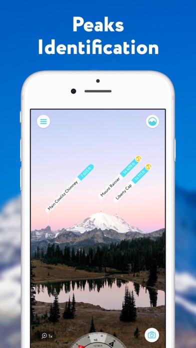
L’app è molto utile, piena di funzionalità, ed è diventata essenziale nel preparare le mie gite in montagna. Presenta dei piccoli difetti però che vorrei far presente allo sviluppatore in modo da rendere quest’app perfetta al 100%. 1. Il design dell’app è ottimo per il riconoscimento immediato delle vette intorno a noi, dopotutto l’app comincia già in realtà aumentata con le montagne intorno a noi in evidenza. Ho trovato qualche difficoltà però nell’uso dell’app durante il trekking mentre sono in movimento. In quel caso, la realtà aumentata mi obbliga a fermarmi e a orientare il cellulare interrompendo il flow del trekking, mentre un indicatore più generale di posizione rispetto al sentiero potrebbe essere più utile. La realtà aumentata rimane comunque essenziale nell’uso dell’app, ma dovrebbe attivarsi solo se riconosce che siamo stazionari e magari servirebbe una modalità parallela bidimensionale da attivare quando si vuole seguire un percorso o una traccia pre-registrata. 2. L’app su Apple Watch è perfettamente inutile. Serve solo a tracciare un percorso e mostra una vista satellitare che su uno schermo così piccolo serve a poco. Gradirei anche in quel caso avere una visione stilizzata e bidimensionale, adatta ad uno schermo così piccolo, per seguire una traccia predefinita. E magari perché no, a quel punto uno potrebbe anche sbizzarrirsi e mettere una seconda “scheda” nell’app per Apple Watch dove si ha una visione panoramica stilizzata delle vette intorno a noi. Altrimenti allo stato attuale l’app per Apple Watch risulta inutilizzata. A parte queste pecche di design, l’app ha tutte le funzionalità che mi servono e la reputo (quasi) perfetta.
|
Diagramm
|
Kategorie
|
Rang
|
|---|---|---|
|
Top Umsatz
|

|
3
|
|
Top Umsatz
|

|
5
|
|
Top Umsatz
|

|
6
|
|
Top Umsatz
|

|
7
|
|
Top Umsatz
|

|
8
|
| Name | Rezensionen | Bewertungen | Letzte Veröffentlichung | |
|---|---|---|---|---|

PeakFinder
The mountains are calling!
|
4
|
5
|
vor 1 Monat | |

Travel Altimeter & Elevation
Barometer, Altitude, Sea Level
|
4
|
|
vor 4 Monaten | |

SwitzerlandMobility
Non-motorized traffic network
|
0
|
|
vor 2 Monaten | |

Topo Maps+
Offline Topographic Maps & GPS
|
4
|
|
vor 1 Woche | |

bergfex: hiking & tracking
Tour planner & GPS navigation
|
1
|
|
vor 1 Woche | |
Gaia GPS: Mobile Trail Maps
Hiking, Overlanding, Camping
|
4
|
|
vor 2 Wochen | |

Outdooractive
Reliable planning & navigation
|
6
|
|
vor 2 Tagen | |

alpenvereinaktiv
Tourenportal der Alpenvereine
|
0
|
|
vor 2 Tagen | |

swisstopo
Official Swiss Maps
|
0
|
|
vor 2 Monaten | |

Swiss3D
Peak detection
|
0
|
|
vor 3 Wochen |
