Topo Maps+

Offline Topographic Maps & GPS

Veröffentlicht von: Glacier Peak Studios

Beschreibung

‣‣ MAPAS PARA CADA ACTIVIDAD
‣ Configura tu mapa según tu actividad planificada

‣‣ HERRAMIENTAS DE PLANIFICACIÓN
‣ Compara y descarga mapas para usar sin conexión.
‣ Combina superposiciones para personalizar la vista de tu mapa
‣ Herramientas inteligentes para crear rutas
‣ Waypoints
‣ Imprime, envía por correo electrónico o comparte mapas y rutas personalizados
‣ Límites de terrenos públicos, privados y de caza
‣ Información de parcelas
‣ Crea equipos y comparte en vivo la última ubicación conocida de los miembros

‣‣ HERRAMIENTAS EN RUTA (sin conexión)
‣ Ve tu ubicación actual
‣ Todos los mapas y superposiciones se pueden descargar
‣ Graba tus recorridos: mira dónde has estado
‣ Waypoints fotográficos: toma una foto y se muestra instantáneamente en el mapa
‣ Progreso en la ruta: cuánto más te queda el sendero
‣ Guíame: a un punto de referencia
‣ Alertas de proximidad: avísame cuando estoy cerca de un punto de referencia, sendero o región
‣ Línea de visión: ¿qué estoy mirando?
‣ Datos de elevación descargados para la creación de rutas en el sendero

‣‣ APPLE WATCH
‣ Integración con Apple HealthKit
‣ Descargar mapas directamente al reloj
‣ Desplazarse y hacer zoom en el mapa como en el teléfono
‣ Soltar un punto de referencia
‣ Grabar un recorrido y ver todas sus estadísticas

‣‣ CARPLAY
‣ Navegar hasta el comienzo del sendero
‣ Indicaciones paso a paso en las carreteras de USFS


INFORMACIÓN DE PAGO DE SUSCRIPCIÓN
Las suscripciones a Topo Maps+ se cargarán a su cuenta de ID de Apple en la confirmación de la compra y/o finalización de la prueba gratuita. La suscripción se renueva automáticamente a menos que se cancele al menos 24 horas antes del final de la prueba gratuita o del período actual. Se cobrará a su cuenta la renovación dentro de las 24 horas anteriores al final del período actual. Puede administrar y cancelar sus suscripciones yendo a la configuración de su cuenta en la App Store después de la compra.
SUBSCRIPTION PAYMENT INFORMATION
Topo Maps+ subscriptions will be charged to your Apple ID account at the confirmation of purchase and/or completion of free trial. Subscription automatically renews unless it is canceled at least 24 hours before the end of the free trial or current period. Your account will be charged for renewal within 24 hours prior to the end of the current period. You can manage and cancel your subscriptions by going to your account settings on the App Store after purchase.

Política de privacidad: https://topomaps.co/info/privacy
Condiciones del servicio: https://topomaps.co/info/tos
El uso continuo del GPS en segundo plano puede reducir drásticamente la duración de la batería.
Ausblenden Mehr anzeigen...

In-App-Käufe

Topo Maps+ Pro
$999.00
12 Month Map Pass
$399.00
3 Month Map Pass
$249.00
Topo Maps+ Essentials
$499.00
"2 Month Map Pass"
$199.00
Topo Maps+ Elite
$1,499.00
Topo Maps+ Essentials 3 Months
$299.00
6 Month Map Pass
$299.00
Topo Maps+ Elite: 3 Months
$589.00

Screenshots

Topo Maps+ Häufige Fragen

  • Ist Topo Maps+ kostenlos?

    Ja, Topo Maps+ ist kostenlos herunterzuladen, enthält jedoch In-App-Käufe oder Abonnements.

  • Ist Topo Maps+ seriös?

    🤔 Die Qualität der Topo Maps+-App ist gemischt. Einige Nutzer sind zufrieden, während andere Probleme melden. Ziehen Sie in Betracht, einzelne Bewertungen für mehr Kontext zu lesen.

    Danke für die Stimme

  • Wie viel kostet Topo Maps+?

    Topo Maps+ bietet mehrere In-App-Käufe/Abonnements, der durchschnittliche In-App-Preis beträgt $559.00.

  • Wie hoch ist der Umsatz von Topo Maps+?

    Um geschätzte Einnahmen der Topo Maps+-App und weitere AppStore-Einblicke zu erhalten, können Sie sich bei der AppTail Mobile Analytics Platform anmelden.

Benutzerbewertung

4.92 von 5

13 Bewertungen in Mexiko

5 star
12
4 star
1
3 star
0
2 star
0
1 star
0
Bewertungsverlauf

Topo Maps+ Bewertungen

Garbage

VdellaV on

Mexiko

Crashes, localization not accurate, If I didn't have wikiloc running on my iPhone I would have gotten lost

New user hopefully.

river.otter on

Vereinigte Staaten

It seems impossible to install.

Finally an app that’s mapped the west

utah cyclist on

Vereinigte Staaten

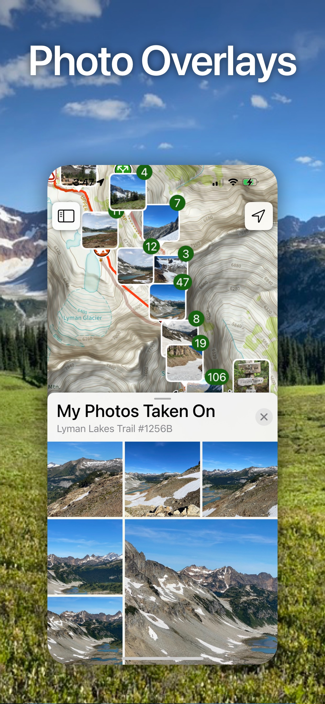
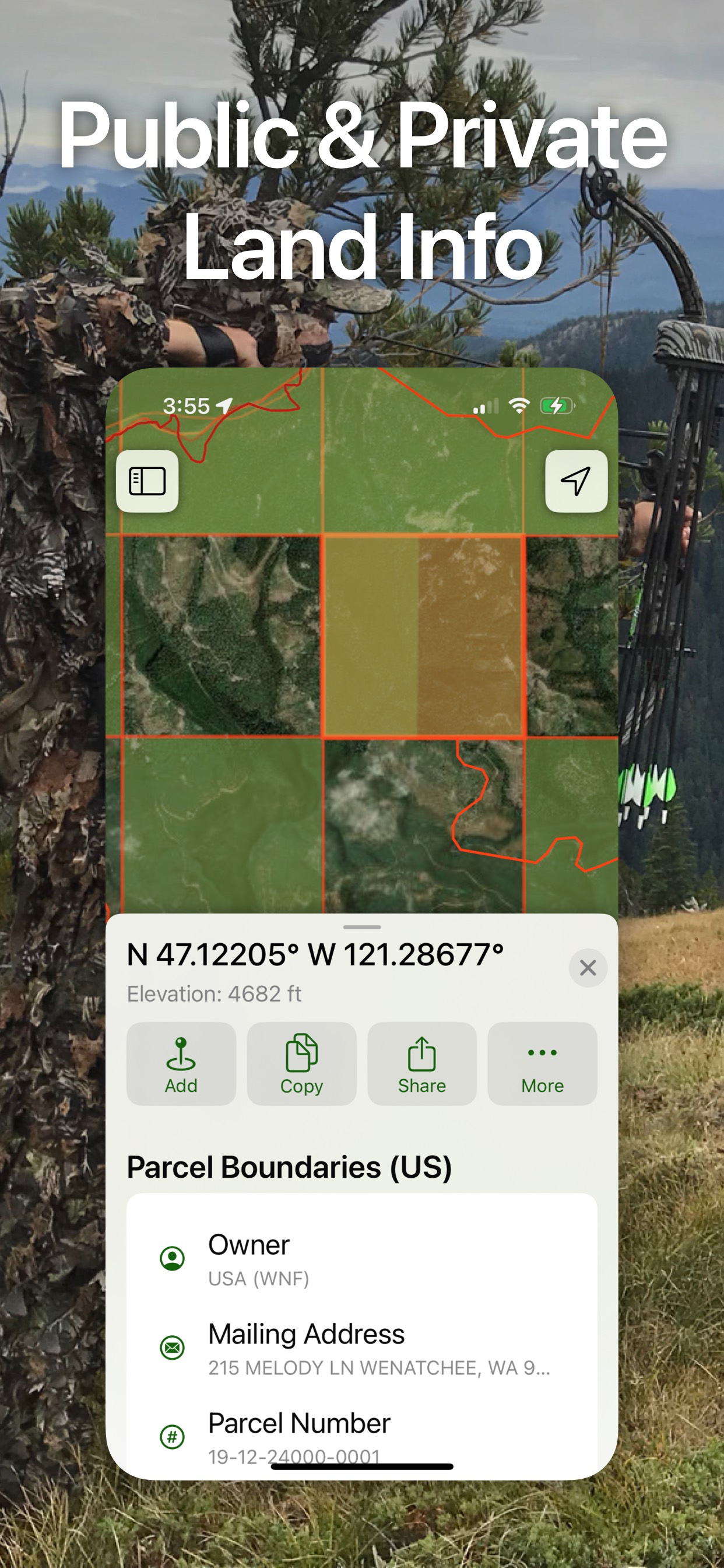
I’ve spent so much money on apps that have empty promises. Togo Maps+ has trails and more trails! I get that the west has a lot of open space but for us that equals Trails!! I know the surrounding area where I live and was surprised that local trails where in the app. If you’ve been struggling to find an app that has trails this is it, look no further. I hike, off road and atv so having everything in one app=priceless!

Route creation is a nightmare

Wacbravo on

Vereinigte Staaten

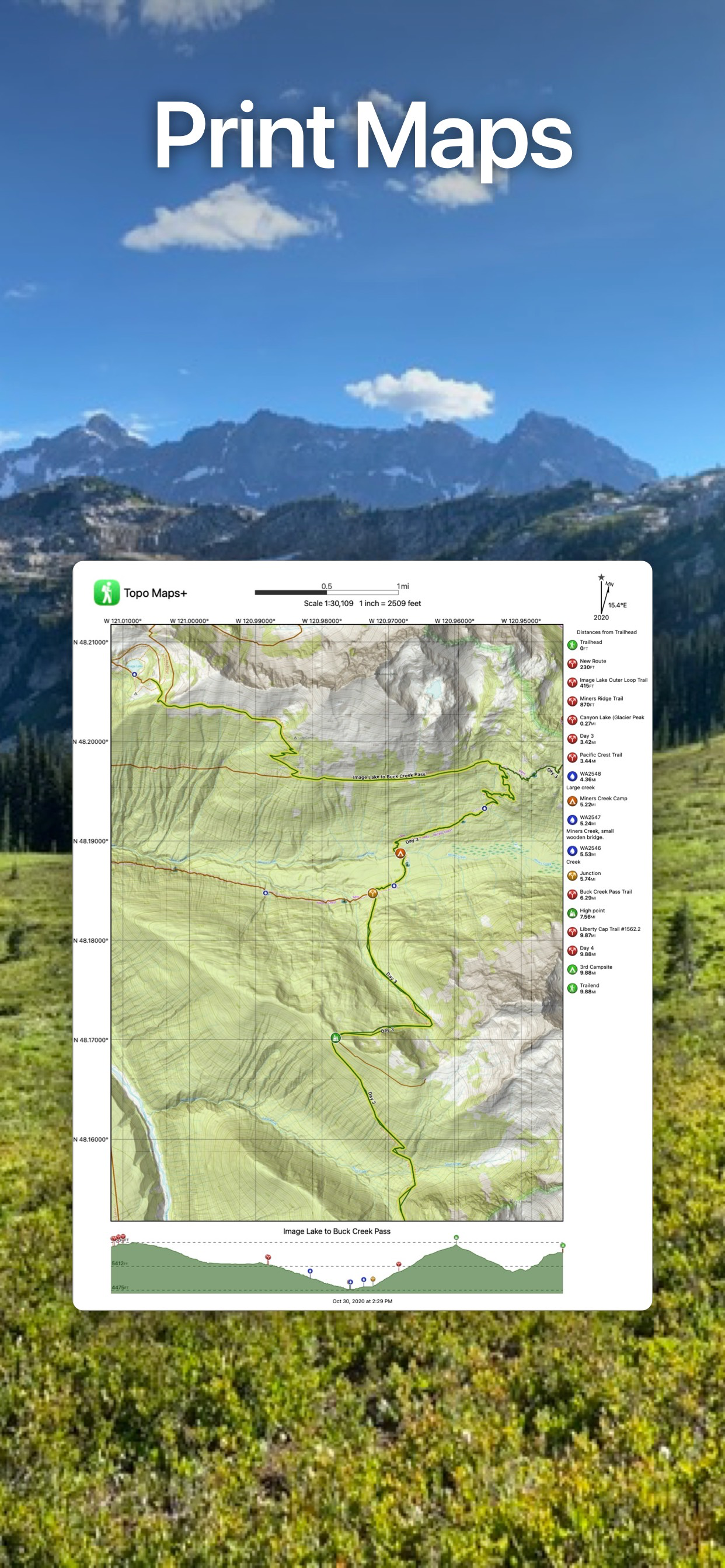
The snap-to trail route creating function is almost non-existent. You can only snap to a handful of trails and then only with a specific overlay, and it won’t snap to other well-denoted trails or roads on the base map. To make even the most basic of routes, you end up having to do a lot of free-hand creation or settling on straight lines for your route . Since I do a lot of route-making, this app fell way short for me. It is an aesthetically pleasing app overall though, and I really enjoy the quality and variety of the basemaps. If the route making gets an overhaul, I’d be happy to give it another go.

Help please.

ricster53 on

Vereinigte Staaten

I wish there was a bit more road map info. Rt # or names easier to find.

Best hiking app

@lsparks_flyin on

Vereinigte Staaten

Easy to use and always working offline when I need it to deep in the woods.

My Favorite App!

Biola Student on

Vereinigte Staaten

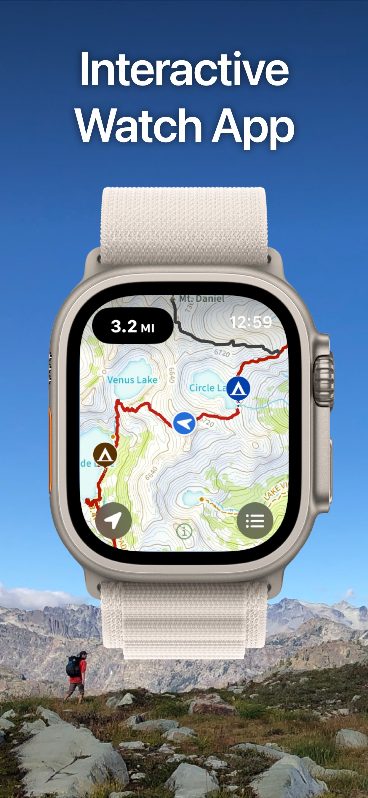
I backpack and peak climb in the Sierras a lot, and this app is perfect for what I need. I use it both on my iPhone and Apple Watch. It has so many great features. Too many to list. Compared it with OnX Backcountry, and this app is much better.

Not very accurate

Ingridyxu on

Vereinigte Staaten

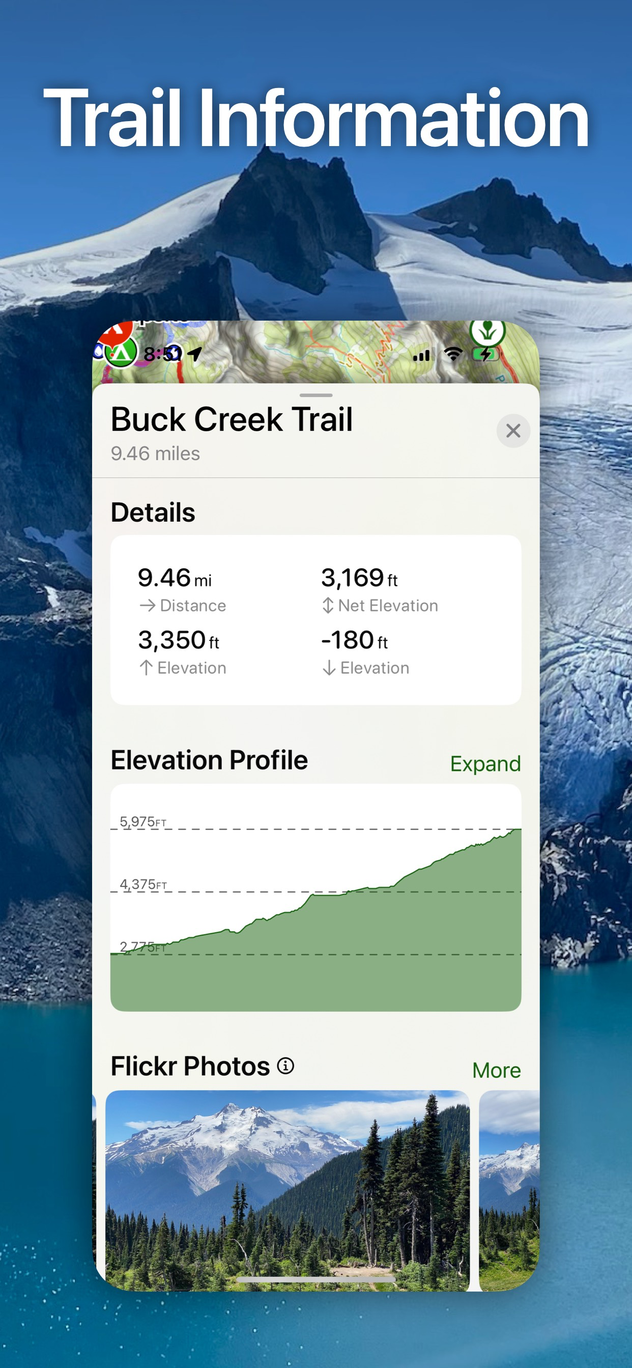
I like this Topo Maps, it can be used offline, but the problem is not very accurate, especially uphill, always longer than actual, I hiked Mount Si, both All Trails and trail information says it is a 4-mile trail one way, Topo recorded 5.2 miles when I walked uphill, and 4 miles when I walked same route down.

Made by real people who care

Iksea76 on

Vereinigte Staaten

I have used this app for almost 10 years since it’s infancy. Stephen continues to improve it and is super responsive to feature requests and bug fixes. He recently added an easy way to toggle all ,y waypoints on and off on map view without having to add them all individually to folders. Super efficient off cell service and a lot of different map layers available. All user data is cloud backed up so I now have so much history.

Great for hunting hiking !

dfisf on

Vereinigte Staaten

When scouting for deer sign no worry just use to return to start point

Store-Rankings

Ranking-Verlauf
Kategorien-Rankings
Diagramm
Kategorie
Rang
Top Umsatz
18
Top Umsatz
19
Top Umsatz
38
Top Umsatz
38
Top Umsatz
46

Schlüsselwörter

Topo Maps+ Konkurrenten

Topo Maps+ Installationen

Letzte 30 Tage

Topo Maps+ Umsatz

Letzte 30 Tage

Topo Maps+ Einnahmen und Downloads

Gewinnen Sie wertvolle Einblicke in die Leistung von Topo Maps+ mit unserer Analytik.
Melden Sie sich jetzt an, um Zugriff auf Downloads, Einnahmen und mehr zu erhalten.
This page includes copyrighted content from third parties, shared solely for commentary and research in accordance with fair use under applicable copyright laws. All trademarks, including product, service, and company names or logos, remain the property of their respective owners. Their use here falls under nominative fair use as outlined by trademark laws and does not suggest any affiliation with or endorsement by the trademark holders.