Описание
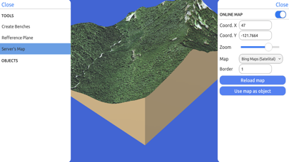
Directly from the internet; Bing Maps, Mapbox, and ArcGIS or from a cloud point stored locally.
Export real data:
From point cloud data in CSV or TXT to 3D models in STL or OBJ and satellite images.
Operate:
Cut, re-scale, and animate models for representation, analysis, and calculations.
Compute operations:
Calculate surface areas and volumes of a model in real-world units with little difference compared to ArcGIS.
Explore:
Character controller geo positioned in real-world coordinate systems such as UTM and Geographic Coordinate System.
Встроенные покупки
- Weekly License
- Rp 55ribu
- Yearly License
- Rp 1,599juta
- Monthly License
- Rp 149ribu
Скриншоты
3D GIS Digital Elevation Model Частые Вопросы
-
Приложение 3D GIS Digital Elevation Model бесплатное?
Да, 3D GIS Digital Elevation Model можно скачать бесплатно, однако в приложении есть встроенные покупки или подписки.
-
Является ли 3D GIS Digital Elevation Model фейковым или мошенническим?
Недостаточно отзывов для надежной оценки. Приложению нужно больше отзывов пользователей.
Спасибо за ваш голос -
Сколько стоит 3D GIS Digital Elevation Model?
3D GIS Digital Elevation Model имеет несколько покупок/подписок внутри приложения, средняя цена покупки составляет 68.53 Rp.
-
Сколько зарабатывает 3D GIS Digital Elevation Model?
Чтобы получить оценку дохода приложения 3D GIS Digital Elevation Model и другие данные AppStore, вы можете зарегистрироваться на платформе мобильной аналитики AppTail.


3D GIS Digital Elevation Model Отзывы Пользователей
Оценки


3D GIS Digital Elevation Model Конкуренты
| Name | Скачивания (30d) | Ежемесячный доход | Отзывы | Оценки | Последнее обновление | |
|---|---|---|---|---|---|---|
|
Scenic Map
3D topo maps of the world
|
Открыть
|
Открыть
|
0
|
|
11 месяцев назад | |
|
MineAR: Augmented Reality Map
Upload & view your data in 3D
|
Открыть
|
Открыть
|
0
|
|
2 года назад | |
|
Topo Nomad
USGS Topographical Maps
|
Открыть
|
Открыть
|
1
|
|
2 года назад | |
|
Route3D 3.0
Topo map navigation
|
Открыть
|
Открыть
|
0
|
|
2 года назад | |
|
MyGIS
Your Navigation Companion
|
Открыть
|
Открыть
|
0
|
|
10 месяцев назад | |
|
Topo Reader
USGS Topographical Maps
|
Открыть
|
Открыть
|
1
|
|
2 года назад | |
|
LiveTopo
Maps for Geology Lovers
|
Открыть
|
Открыть
|
0
|
|
1 год назад | |
|
Scenic Map Grand Canyon
N/A
|
Открыть
|
Открыть
|
0
|
|
10 месяцев назад | |
|
Elevation For Real
|
Открыть
|
Открыть
|
0
|
|
3 месяца назад | |
|
Theodolite HD
AR Navigation Viewfinder
|
Открыть
|
Открыть
|
2
|
|
1 год назад |
3D GIS Digital Elevation Model Установки
30дн.3D GIS Digital Elevation Model Доход
30дн.3D GIS Digital Elevation Model Доходы и Загрузки
Зарегистрируйтесь сейчас, чтобы получить доступ к статистика загрузок и доходов и многому другому.
Информация о приложении
- Категория
- Navigation
- Разработчик
- Andres Narvaez
- Языки
- English
- Последнее обновление
- 1.1 (3 года назад )
- Выпущено
- Jun 15, 2021 (3 года назад )
- Также доступно в
- Эквадор, Соединенные Штаты, Перу, Чили, Малайзия, Филиппины, Новая Зеландия, Норвегия, Нидерланды, Нигерия, Польша, Мексика, Ливан, Казахстан, Кувейт, Республика Корея, Япония, Пакистан, Индия, Португалия, Россия, Саудовская Аравия, Швеция, Сингапур, Словения, Таиланд, Турция, Тайвань, Украина, Вьетнам, Южно-Африканская Республика, Доминиканская Республика, Аргентина, Австрия, Австралия, Азербайджан, Бельгия, Бразилия, Беларусь, Канада, Швейцария, Китай, Колумбия, Чехия, Германия, Дания, Италия, Алжир, Египет, Испания, Финляндия, Франция, Великобритания, Греция, Гонконг (САР), Венгрия, Индонезия, Ирландия, Израиль, ОАЭ
- Обновлено
- 1 день назад


