LidarCad

Professional Cad Solution

Разработчик: Svetlana Sandalova

Описание

LidarCad combines CAD Editor and LiDAR Scanner into one Application. With LidarCad it is easy to estimate volumes of sand or gravel, capture point clouds, measure length, area and so on. LidarCad works with DWG/DXF files. Results can be exported to other popular formats.
Scan functionality available on LiDAR-enabled devices. It includes:
* Estimate cut/fill volumes using base plane
* Estimate cut/fill using limited boundary
* Capture point clouds
* Add points with XYZ(WGS) coordinates
* Define CS Origin for scan
* Measure length/area
Full description and manuals available on page: http://cadspace.xyz/Features/
CAD editor contains tools to create Drawings. It supports connection to your bluetooth rangefinder. Measurements transmitted directly to drawing, it is possible to set exact length for selected line, or add text with transmitted value. This is a list of supported devices:
* Bosch GLM50C, GLM100C, GLM120C
* Bosch PLR30C, PLR40C, PLR50C
* Leica DISTO D110, D1, D2
* Leica DISTO D510, D810, S910
* Leica DISTO X3, D8
* Condtrol Vector
For devices without LiDAR sensor full functional CAD editor available.
Скрыть Показать больше...

Скриншоты

LidarCad Частые Вопросы

  • Приложение LidarCad бесплатное?

    Да, LidarCad полностью бесплатное и не содержит встроенных покупок или подписок.

  • Является ли LidarCad фейковым или мошенническим?

    Недостаточно отзывов для надежной оценки. Приложению нужно больше отзывов пользователей.

    Спасибо за ваш голос

  • Сколько стоит LidarCad?

    Приложение LidarCad бесплатное.

  • Сколько зарабатывает LidarCad?

    Чтобы получить оценку дохода приложения LidarCad и другие данные AppStore, вы можете зарегистрироваться на платформе мобильной аналитики AppTail.

Оценки пользователей

3.5 из 5

6 оценок в Великобритания

5 star
2
4 star
2
3 star
0
2 star
1
1 star
1
История оценок

LidarCad Отзывы Пользователей

Export to pts / network problem

Mr xxfgbu on

Великобритания

There is problem with exporting to pts end saving file. Not working after the iOS update.

Yes but almost

Zybnw on

Великобритания

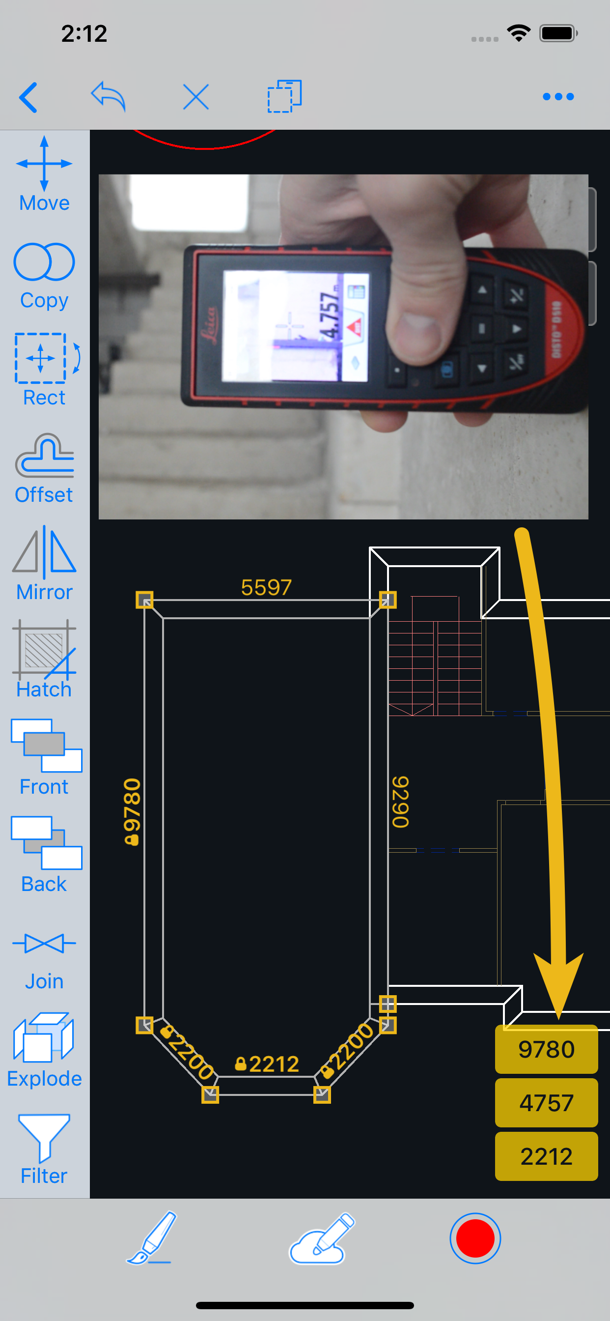
Almost what we need. Unfortunately we still need to convert the point cloud in recap as no rcp Rcs export option. There doesn’t seem to be a way to create a textured mesh from the images like some of the other 3d scan apps which would be very useful where text is hard to make out from a point cloud. Presumably the images/video isn’t saved from the scan? Also have an error NLS files missing Roman Mac to ansi 1252 when trying to open in windows autocad. Display with Line weight would be a good option as is difficult to see while drawing. We tried changing but the view was unaffected. Fading the pointcloud or setting transparency would be another useful option to have. Otherwise.. fast and easy to use scanner with a good amount of tools to mark up for use in cad software.

Waste of money

tyiggy on

Великобритания

Not what I was expecting does not have scan to plan function that I could find , very poor if any instructions how to use it. Pay up front , no trial period waste of money .

Brilliant..

7502stephen on

Великобритания

As part of my job I have to manage stockpiles of rock salt for the gritting of roads during winter and the volume measurement ability of this app will be very useful. I tested the app against a known quantity of 1,400 tons (1,400/1.378 m3) of rock salt in the barns and it proved very very accurate. Delighted.

Lidar survey to cad

Mc and rev136 on

Великобритания

A great survey tool, wall and surface recognition.. Outputs straight to AutoCAD to convert the mesh to surface in civil 3D (ensure you use the in app explode feature to ensure Civil3d can create the surface). This allows the production of sections through the Point cloud or triangulated planes.

LidarCad Survey

Ukkml on

Великобритания

Early impressions are that this is the software to use if you are completing site surveys into CAD programmes. It’s compatible with the programme I use, and makes the CAD collection from site so much quicker and impressive.

Оценки

История позиций в топах
История рейтингов пока не доступна
Позиции в категории
Рейтинг
Категория
Позиция
Топ платных
9
Топ платных
24
Топ платных
107
Топ платных
110
Топ платных
175

LidarCad Конкуренты

LidarCad Установки

30дн.

LidarCad Доход

30дн.

LidarCad Доходы и Загрузки

Получите ценные инсайты о производительности LidarCad с помощью нашей аналитики.
Зарегистрируйтесь сейчас, чтобы получить доступ к статистика загрузок и доходов и многому другому.

Информация о приложении

Категория
Productivity
Разработчик
Svetlana Sandalova
Языки
English
Последнее обновление
1.9.10 (2 года назад )
Выпущено
Jan 12, 2019 (6 лет назад )
Также доступно в
Соединенные Штаты, Великобритания, Россия, Германия, Франция, Индия, Мексика, Республика Корея, Канада, Япония, Нидерланды, Индонезия, Румыния, Швеция, Кипр, Испания, Китай, Италия, Бразилия, Казахстан, Тайвань, Австралия, Норвегия, Польша, Непал, Нигерия, Малайзия, Мальта, Северная Македония, Мадагаскар, Латвия, Словения, ОАЭ, Вьетнам, Узбекистан, Украина, Турция, Тунис, Таиланд, Словакия, Новая Зеландия, Сингапур, Саудовская Аравия, Португалия, Южно-Африканская Республика, Пакистан, Филиппины, Перу, Алжир, Армения, Аргентина, Австрия, Азербайджан, Бельгия, Болгария, Бахрейн, Бруней, Беларусь, Швейцария, Чили, Колумбия, Чехия, Дания, Доминиканская Республика, Люксембург, Эквадор, Эстония, Египет, Финляндия, Греция, Гонконг (САР), Хорватия, Венгрия, Ирландия, Израиль, Исландия, Кувейт, Ливан, Шри-Ланка, Литва
Обновлено
2 недели назад
This page includes copyrighted content from third parties, shared solely for commentary and research in accordance with fair use under applicable copyright laws. All trademarks, including product, service, and company names or logos, remain the property of their respective owners. Their use here falls under nominative fair use as outlined by trademark laws and does not suggest any affiliation with or endorsement by the trademark holders.