Air Navigation Pro
The Pilot Assistant
#1 Keyword Rankings
Today
Top 10 Rankings
Today
Top 30 Rankings
Today
Top 100 Rankings
Today

Description

Discover our flight planning & real-time navigation app for free for 28 days!
- Everything you need to fly around the world
- Plan your flight in a few minutes
- Fly relaxed with up-to-date information

Air Navigation Pro is a high-quality flight assistant app for pilots worldwide. Benefit from the following main features:

MOVING MAP
Plan and navigate using our interactive moving map. Choose between aeronautical charts, satellite or our vector map as a background. On top of that, the moving map displays waypoints, NOTAM, obstacles and airspaces from our comprehensive, always up-to-date worldwide aeronautical database. Tap on any waypoint directly on the map to easily create a route. Personalize the values shown on the navbar to have exactly the information you need: altitude, vertical speed, bearing, distance to the next waypoint, ETA calculations, etc. Choose the airport departure and arrival procedures for your route to have them also displayed on top of the moving map.

ENHANCED TRAFFIC AWARENESS
Get visual and audio alerts in all languages for nearby conflicting traffic. Choose your preferred traffic icon between generic, aircraft or TCAS symbols. Your safety is important to us, which is why we partnered with SafeSky to ensure our users have live traffic data during their flight. Benefit from the native integration with SafeSky included in our new Smart Lite, Smart Classic and Smart Advanced subscriptions—a two-in-one package!

ADVANCED WEATHER LAYERS
In addition to the basic weather reports & forecast of winds, TAF and METAR for your flight, subscribers of the Smart Advanced plan can activate see-through weather layers on top of the moving map. Available layers include rain radar, wind, pressure, clouds and rain, visibility, gust and for Germany, Switzerland, Austria and the Balkans, we also have GAFOR. Tap on any point on the map to see the weather information for that area. Review the weather forecast for up to three days ahead.

NOTAM
After creating your route, set the departure time in the future to have the moving map display the NOTAM active for that specific time. NOTAM on the map change color dynamically based on their status.

SMARTCHART
Our cutting-edge SmartChart is a highly detailed and intelligent vector-based map that adapts to your needs, providing you with adequate information at any zoom level. The SmartChart optimizes the display of shadows to easily distinguish between valleys and mountains, and the text remains perfectly aligned, guaranteeing optimal readability. Including the latest significant improvements with forests and detailed airport information.

ELEVATION PROFILE & SYNTHETIC VIEW
Enable the profile view below the navbar for enhanced situational awareness of the elevation ahead of you or along your route. Choose the corridor width between 0 to 5 NM and overlay options: airspaces, NOTAM, obstacles, wind components, populated places, etc. Switch to the synthetic view for additional terrain information, plus an artificial horizon with altitude and vertical speed indicators. This function can also be used to pan around while preparing for your flight. Activate TAWS on the moving map as well as on the synthetic view.

AERONAUTICAL CHARTS & APPROACH CHARTS
We offer the most extensive worldwide catalog of aeronautical charts, including the ICAO charts. Have the georeferenced approach charts displayed on top of the moving map or the 3D view.

BRIEFING
Prepare your flight with our briefing section by creating documents with NOTAM and weather charts & stations relevant to your planned route. Optimize time by creating an aircraft profile which will be used in the Briefing section to pre-fill for you the ATC Flight Plan and calculate the W&B.

AND SO MUCH MORE!

Please note that WiFi-only devices do not include an internal GPS receptor; for these devices, an external sensor is required. Refer to our user manual on our website: www.airnavigation.aero for more information.
Hide.. Show more..

In-Apps

SMART
¥8,800
Smart Lite
¥20,000
Smart - Asia
¥8,700
Smart Plus - Asia
¥11,200
Essential worldwide
¥8,700
Japan - VFR 250k AIS
¥3,500
Japan - VFR 500k AIS
¥6,000
Aeronautical database
¥10,000
Japan - VFR 500k AIS 2022
¥6,000
Japan - Whole country 3D data
¥4,000

Screenshots

User Rating

4.59 out of 5

182 ratings in Japan

5 star
131
4 star
34
3 star
13
2 star
1
1 star
3

Ratings History

Reviews

サポートセンターの対応

みなとの定理 on

エラーが発生してログインできなくなりサポートに問い合わせたところ、とても親身に対応いただきました。 ありがとうございました。 使用感も問題なく普段のフライトにとても役立っております。 英語がある程度使えないと難しいかもしれませんが、きっとまた親切に対応してくれると思います。

以前の様に漢字に対応してほしい

1256984368あはなやわ on

以前は出来ていたウェイポイントの漢字登録ができなくなってしまった。

素晴らしいパイロットサポーターです

Old Cessna Pilot on

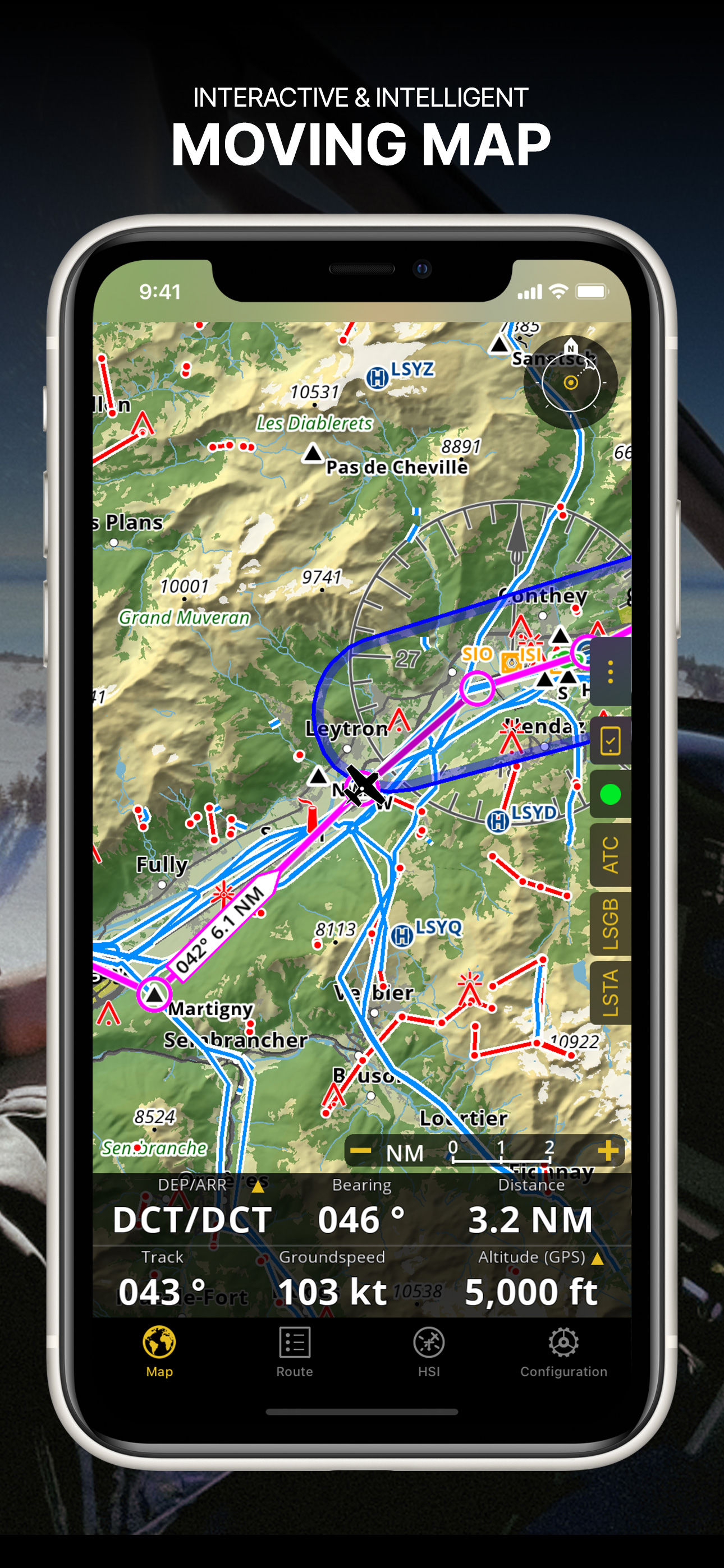
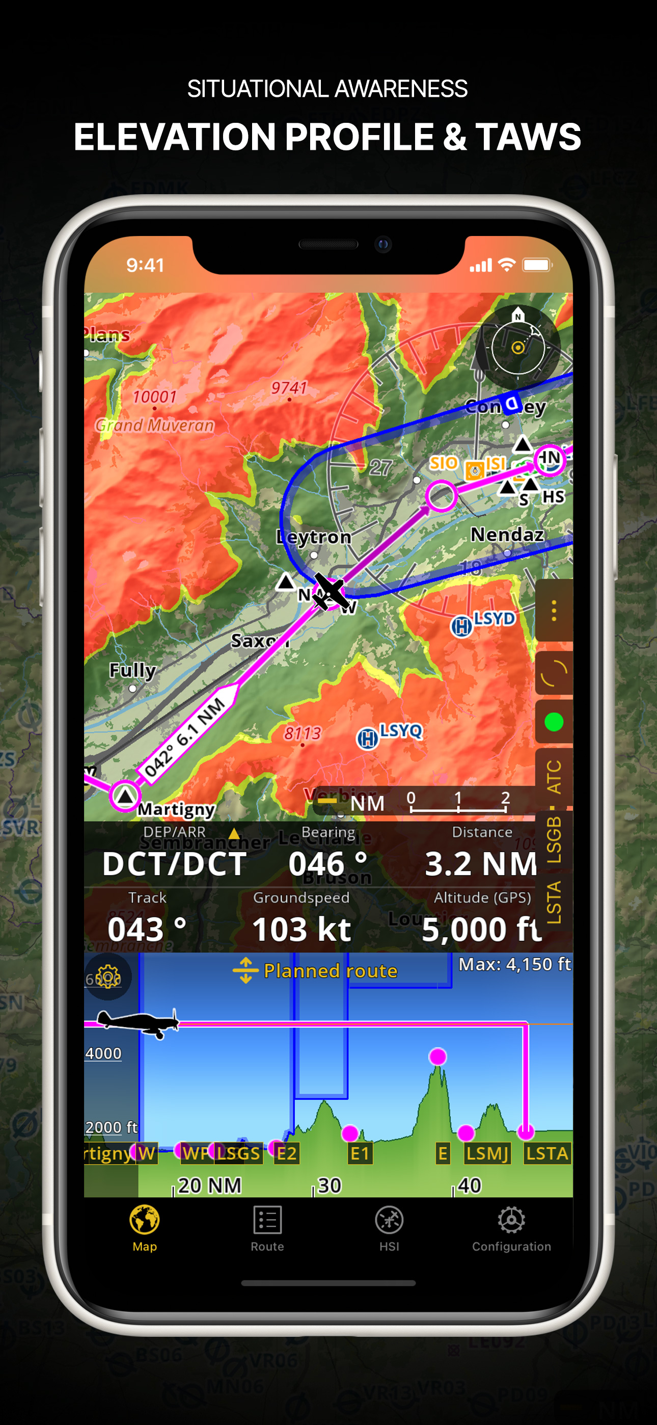
フライト時のナビゲーションを簡単操作で素早く正確にサポートしてくれます。 フライトログやフライトレコーダー機能があり、フライトコースのみならず、高度情報やヘディングまできろされ、保存されます。 その他多様な機能があり、もはやフライトの必需品となっています。

大空の安全 safety for sky

Hiro EC135 on

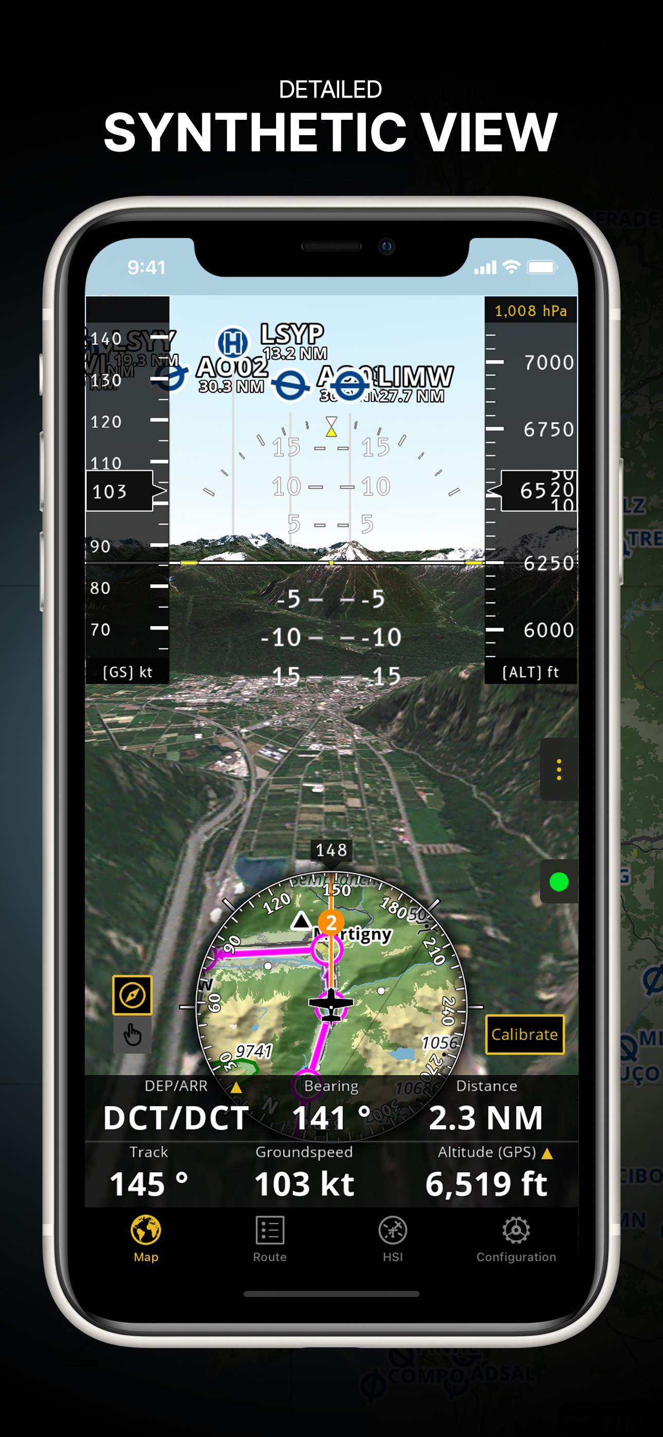
昔からあれば、良かった優れもの、 Gamin1000データーと同一 800万と、Nav Pro

素晴らしい

マスミヨシ on

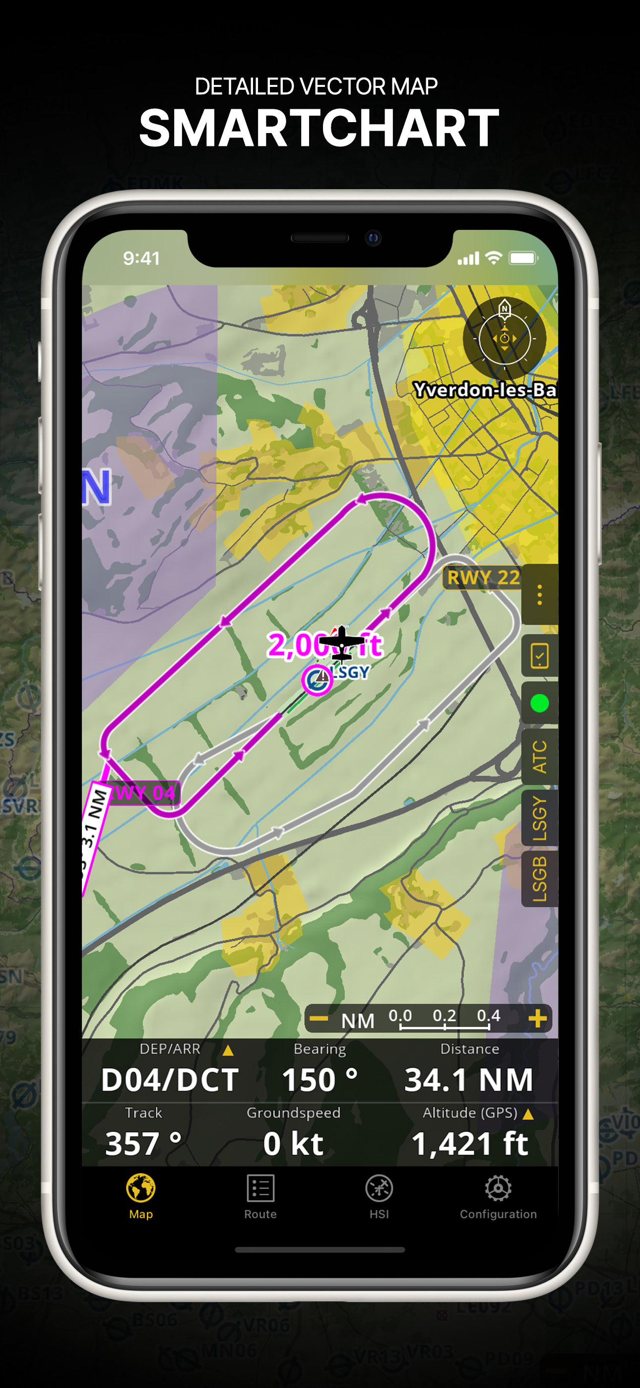
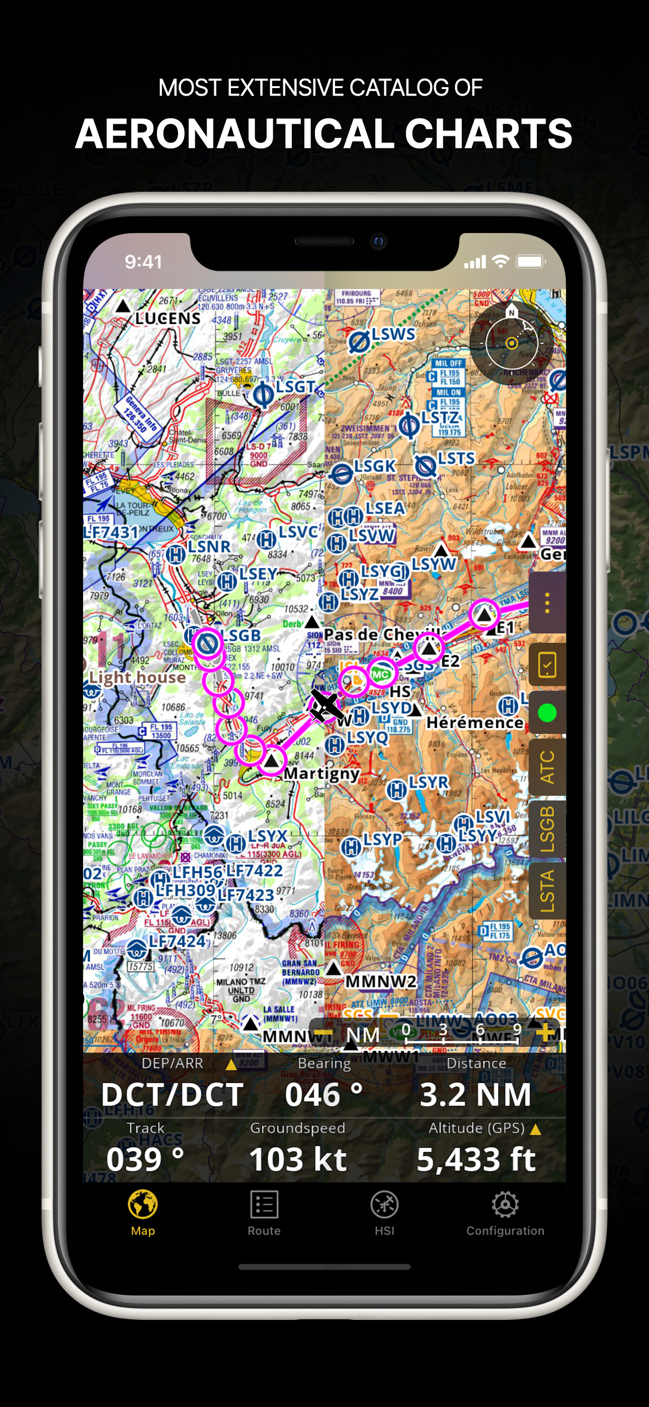
専用の航空機GPS並みの技能で、使い方は簡単。チャートや地形のモニターも世界中の物を購入できる。

アプリ紹介サイトかみあぷさぎ

ほしいもくん on

えっ、期間限定無料ってダウンロードが無料?そんなのさぎでしょ

便利!

ATCだいすき。 on

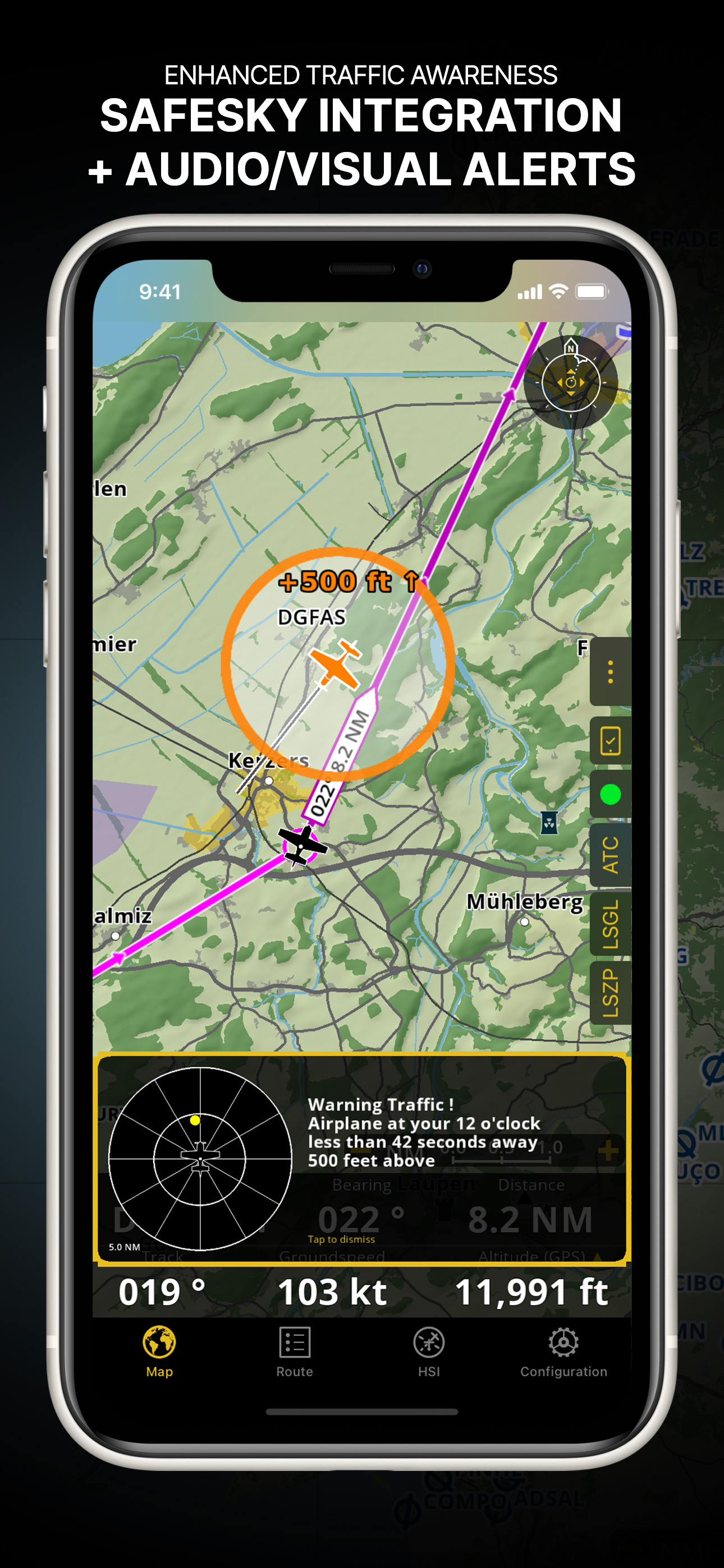
非常に便利です。周波数なんかも空港をタップするだけで出てくるのはかなり良いです。ただ日本の空域も表示しないのが残念です。 精度はかなり良く、RNAVならぬiNAVが出来るのではと思うほどです。今後の空域表示も期待して、星4つにきておきます。

エアスペースが表示できれば文句無し

Lighter tug on

これがあれば迷子にはならない。 初めて空港でも安心 日本のエアスペースが表示できれば文句無し

good for us

hiro135 on

It's very good for pv pilot safty navigation. on aircraft instrument very old. We don't no so good thing in APP STORE now i'm fling PA46marib G-1000 air craft it's same as airnavigation PRO data we know can't use true navgation but i want to tell everybady this is good safty in yoursky safty advice . one request japan controllzoon pojitivi controll area restriczoon plus futer.

バージョン5.6.0にアップデートしたら起動しなくなりました

バージョン5.6.0にアップデートしたら起動しなくなりました on

バージョン5.6.0にアップデートしたら起動しなくなりました。早くバグを修正して欲しいです。

Store Rankings

Ranking History

Category Rankings

Chart
Category
Rank
Top Grossing
3
Top Grossing
4
Top Grossing
4
Top Grossing
5
Top Grossing
7

Keywords

Users may also like

Name
Direct-To Aviation GPS VFR IFR
Air Navigation for Pilots
Airmate
Flight planning/weather
NOTAM Briefing (VFR/IFR)
Your preflight NOTAM check
SDVFR
AeroNOTAM
Get NOTAMs simple and quick
SkyDemon
AeroChart
Aeronautical Charts
FlyGo Air Navigation
Aviation App for Pilots
Navigraph Charts
Jeppesen FliteDeck Pro
Show More

Revenue and Downloads

Gain valuable insights into Air Navigation Pro performance with our analytics. Sign up now to access downloads, revenue, and more.

App Info

Category
Navigation
Publisher
Air Navigation SA
Languages
English, French, German, Italian, Japanese, Norwegian Bokmål, Portuguese, Russian, Spanish, Turkish
Recent version
8.3.376 (1 day ago )
Released on
Jan 6, 2009 (15 years ago )
Last updated
2 days ago